Yellow Creek (Toronto) facts for kids
Quick facts for kids Yellow Creek |
|
|---|---|

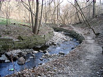
Yellow Creek as it runs through Avoca Ravine next to David A. Balfour Park
|
|
| Country | Canada |
| Province | Ontario |
| City | Toronto |
| Physical characteristics | |
| Main source | Toronto, Ontario, Canada |
| River mouth | Don River, just north of Bloor Street, Toronto, Ontario, Canada |
| Length | 12 km (7.5 mi) |
Yellow Creek is a stream in Toronto, Canada, that flows into the Don River. It is special because a large part of it flows underground. This type of stream is called a subterranean river. Yellow Creek has also been known by other names, such as Silver Creek, Sylvan Creek, and Rosedale Brook.
The creek used to start near Sheppard West station in the Downsview area. Today, most of the creek and its starting points are hidden in underground pipes called storm sewers. It finally appears above ground in the Avoca Ravine, located in the Deer Park neighborhood, and then flows into the Don River.
Contents
Yellow Creek's Journey
Yellow Creek travels about 12 kilometers (7.5 miles) from its source to where it joins the Don River. Much of this journey happens out of sight, underground.
Hidden Underground Sections
The modern Yellow Creek begins as water from storm sewers. These sewers collect rainwater and other water from the city. The creek flows south underground beneath Chaplin Crescent. It then follows the path of the old railway line southeast.
The hidden creek crosses under Yonge Street near the Davisville railyard. It then flows into Mount Pleasant Cemetery. More water from Yonge Street's storm sewers joins the creek here. After this, the creek finally comes out into the open.
Flowing Above Ground
The parts of Yellow Creek that you can see start in a deep valley called the Vale of Avoca. This valley is in the Deer Park neighborhood.
Vale of Avoca
The creek first appears above ground at the southern end of Mount Pleasant Cemetery. It flows into the beautiful Vale of Avoca, also known as the Avoca Ravine. This ravine is a big part of David A. Balfour Park. People sometimes mistakenly call the whole ravine or even the creek itself by the park's name.
The creek flows southeast through this valley. A large bridge, the Vale of Avoca bridge, crosses over the creek in this section. Sometimes, after very heavy rain, the creek can overflow its banks in the ravine. This happens because a lot of water from city storm drains flows into the ravine. When the creek overflows, it can damage the walking trails and small bridges in the park.
Park Drive Reservation Ravine
After flowing through the Avoca Ravine, Yellow Creek goes back underground for a short while. It then reappears in the Park Drive Reservation Ravine. The creek enters the sewers again near Bayview Avenue before it finally joins the Don River.
Protecting Yellow Creek
In 2019, the Toronto and Region Conservation Authority (TRCA) looked at Yellow Creek. They noticed that erosion was damaging the walking paths near the creek. Erosion is when soil and rock are worn away by water.
To fix this, they removed old rock walls that were holding the creek banks. They replaced them with a more gently sloped creek bed. This new design helps the creek flow better and makes it less likely to flood. These changes help Yellow Creek stay healthy and reduce the need for constant repairs.
 | Sharif Bey |
 | Hale Woodruff |
 | Richmond Barthé |
 | Purvis Young |

