Vale of Avoca (bridge) facts for kids
Quick facts for kids Vale of Avoca |
|
|---|---|

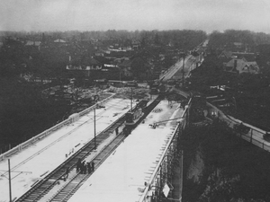
Vale of Avoca nears completion, November 3, 1924
|
|
| Coordinates | 43°41′21″N 79°23′20″W / 43.689160°N 79.388882°W |
| Carries | 5 lanes of St. Clair Avenue (originally 4 lanes with 2 streetcar tracks) |
| Crosses | Vale of Avoca (ravine) |
| Locale | Toronto, Ontario, Canada |
| Other name(s) | St. Clair Viaduct |
| Maintained by | Toronto Transportation |
| Characteristics | |
| Design | Truss arch bridge |
| Total length | 155.1 m (509 ft) |
| Width | 19.7 m (65 ft) |
| Clearance above | 27 m (89 ft) |
| Clearance below | Yellow Creek |
| History | |
| Opened | 1924 |
| Statistics | |
| Daily traffic | St. Clair Avenue East |
| Toll | No |
| Lua error in Module:Location_map at line 420: attempt to index field 'wikibase' (a nil value). | |
The Vale of Avoca is a large bridge in Toronto, Canada. It carries St. Clair Avenue East over a deep valley called the Vale of Avoca ravine. This bridge is also known as the St. Clair Viaduct. It was built in the 1920s to connect two communities: Deer Park and Moore Park. The new bridge replaced an older one and made St. Clair Avenue straighter.
Underneath the bridge, a small stream called Yellow Creek flows. This creek is a branch of the Don River. A beautiful nature trail winds through the Vale of Avoca Ravine, which is part of David A. Balfour Park. The park also has a grassy area where Yellow Creek flows into a small pond.
The bridge and the ravine get their name from a poem by Thomas Moore.
Building the Vale of Avoca Bridge
The very first bridge over the Vale of Avoca ravine was made of iron. It was built in 1888 by a person named John Thomas Moore. He hoped this bridge would encourage people to invest in his new neighborhood, Moore Park.
To help him build the bridge, the Township of York bought some land across the valley. They then leased it to Moore. In return, Moore was given the right to use the land for St. Clair Avenue between Avoca Avenue and Inglewood Drive.
Why a New Bridge Was Needed
In 1912, Moore Park became part of Toronto. This happened because landowners wanted better city services. Over time, the old iron bridge became a safety concern. Because of this, the Toronto City Council decided in 1922 to build a new bridge.
The new bridge was designed to follow a straight line for St. Clair Avenue East. Two houses had to be bought by the city and taken down to make way for the new structure. The new bridge took two years to build and cost a lot of money at the time. It opened for traffic in late 1924.
The Old Bridge and What Happened Next
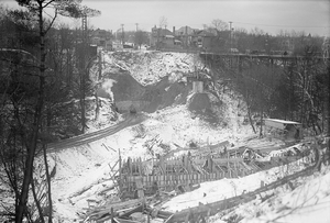
While the new bridge was being built, the old iron bridge stayed open. Cars and streetcars used a detour around the construction. The old bridge crossed the valley at an angle, connecting St. Clair in the east to Pleasant Boulevard.
You can still see parts of the old bridge today. Its eastern support and some concrete foundations are near the edge of the ravine. After the new bridge was finished, the old one was taken apart. The materials from the old bridge were used to make the fence along Avoca Avenue on the west side of the ravine. The Yellow Creek stream at the bottom of the ravine was also changed to flow in a more controlled way to prevent erosion.
In 1973, the City of Toronto government officially named the bridge and the ravine The Vale of Avoca. This name comes from either the poem by Thomas Moore or a river valley in Ireland. The bridge was updated and repaired in 1985.
 | Calvin Brent |
 | Walter T. Bailey |
 | Martha Cassell Thompson |
 | Alberta Jeannette Cassell |


