Youngs River facts for kids
Quick facts for kids Youngs River |
|
|---|---|

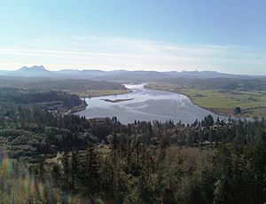
The river as seen from Astoria
|
|
|
Location of the mouth of Youngs River in Oregon
|
|
| Country | United States |
| State | Oregon |
| County | Clatsop County |
| Physical characteristics | |
| Main source | Northern Oregon Coast Range Clatsop County, Oregon 1,131 ft (345 m) 45°59′07″N 123°37′28″W / 45.98528°N 123.62444°W |
| River mouth | Youngs Bay near Astoria, Clatsop County, Oregon 0 ft (0 m) 46°10′51″N 123°52′31″W / 46.18083°N 123.87528°W |
| Length | 27 mi (43 km) |
The Youngs River is a river in northwest Oregon, United States. It flows for about 27 miles (43 km). This river is a branch, or tributary, of the mighty Columbia River. It empties into the Columbia River through a place called Youngs Bay, which is close to the city of Astoria.
The river helps drain water from a part of the Northern Oregon Coast Range mountains. This area is in the very northwest corner of Oregon.
Contents
Where the Youngs River Starts
The Youngs River begins in a quiet, remote area of the mountains. This spot is in central Clatsop County, just north of Saddle Mountain State Natural Area. From there, it flows mostly towards the northwest.
Journey to the Columbia River
As the Youngs River travels, it passes over a beautiful spot called Youngs River Falls. The river then gets wider, forming a large estuary. An estuary is where a river meets the sea, and fresh water mixes with salty water. Finally, it flows into the southern part of Youngs Bay, which connects to the Columbia River near Astoria.
Along its path, the Youngs River gets water from several other smaller rivers and streams. The Klaskanine River joins it from the east, about 5 miles (8 km) south of Astoria. The Wallooskee River also flows into it from the east, about 2 miles (3 km) south of Astoria.
Famous Falls and Explorers
About 13 miles (21 km) from where the river meets the bay, you'll find Youngs River Falls. This waterfall is 54 feet (16 meters) tall!
These falls were discovered in 1806 by a group of explorers. They were part of the famous Lewis and Clark Expedition. This hunting party came from their nearby camp, Fort Clatsop. William Clark, one of the expedition leaders, wrote about the falls in his journals.
Other Streams Joining the River
Many smaller streams and creeks flow into the Youngs River. Some of these include Fall Creek, South Fork Youngs River, and Fox Creek. Other creeks like Osgood, Rock, Bayney, Wawa, and Moosmoos also join the river.
Further downstream, you'll find Cooperage, Battle Creek, Tucker, Casey, Binder, and Cook sloughs. A slough is a type of wetland or a slow-moving channel of water. Crosel, Brown, and Craig creeks also add to the river's flow. Finally, Knowland Slough and the Lewis and Clark River join the Youngs River before it reaches Youngs Bay.
 | Bessie Coleman |
 | Spann Watson |
 | Jill E. Brown |
 | Sherman W. White |


