Yuluma, New South Wales facts for kids
Quick facts for kids YulumaNew South Wales |
|
|---|---|

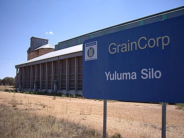
Yuluma Silo
|
|
| Postcode(s) | 2645 |
| Elevation | 149 m (489 ft) |
| Location |
|
| LGA(s) | Federation Council |
| County | Urana |
| State electorate(s) | Wagga Wagga |
Yuluma is a small country area, also known as a rural community, in the central part of New South Wales, Australia. It is located in a region called the Riverina. Yuluma is also known for its old railway station.
Where is Yuluma?
Yuluma is found in the middle of the Riverina region. This area is known for its farming and wide-open spaces. By road, Yuluma is about 7 kilometres (4.3 miles) southwest of a town called Boree Creek. It is also about 29 kilometres (18 miles) northeast of another town, Urana.
The Yuluma Railway Station
Yuluma was once an active railway station. It was part of the railway line that connected The Rock to Oaklands. This station was quite far from Sydney, about 616 kilometres (383 miles) by rail.
The Yuluma railway station was open for many years. It started operating in 1911. Trains used to stop here, likely helping local farmers and residents. However, the station closed down in 1975.
| Preceding station | Former Services | Following station | ||
|---|---|---|---|---|
| Cullivel
towards Oaklands
|
Oaklands Line | Boree Creek
towards The Rock
|
||
 | Bayard Rustin |
 | Jeannette Carter |
 | Jeremiah A. Brown |


