Zarzal facts for kids
Quick facts for kids
Zarzal, Valle del Cauca
|
|||
|---|---|---|---|
|
Municipality and city
|
|||
| City of Zarzal, Valle del Cauca | |||
 |
|||
|
|||
| Nickname(s):
"Sweet Land of Colombia", "The Z"
|
|||

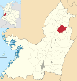
Location of the town and municipality of Zarzal in Valle del Cauca Department.
|
|||
| Country | Colombia | ||
| Department | Valle del Cauca | ||
| Region | Andean | ||
| Demonym | Zarzaleno | ||
| Foundation | April 1, 1909 | ||
| Area | |||
| • Municipality and city | 367.9 km2 (142.0 sq mi) | ||
| • Urban | 4.88 km2 (1.88 sq mi) | ||
| Elevation | 916 m (3,005 ft) | ||
| Population
(2018 census)
|
|||
| • Municipality and city | 41,925 | ||
| • Density | 113.958/km2 (295.15/sq mi) | ||
| • Urban | 31,812 | ||
| • Urban density | 6,519/km2 (16,884/sq mi) | ||
| Time zone | UTC-5 | ||
| Website | www.valledelcauca.gov.co/zarzal |
||
| * | |||
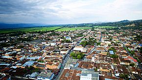
Zarzal is a city and municipality located in the northern part of the Valle del Cauca department in Colombia. Its economy mainly relies on growing lots of sugar cane. It also has small and medium-sized businesses that work with metals.
Trade is very important here. There are many shops that sell everyday items. The city also has a big marketplace that people from nearby towns use. About 42,000 people live in Zarzal. New parts of the city have been built, making it hard to find empty land.
Contents
Geography of Zarzal
Most of Zarzal's land is flat. It sits in the valley of the Cauca River. The Cauca River flows into another river called La Paila River.
Natural Attractions
The municipality is home to several beautiful natural spots. These include the Caracolíes forest, Los Chorros, and Cumba recreational park. You can also find the La Paila river, Mount Caré, and Mount Pan de Azúcar here.
Zarzal's Climate
Zarzal has a tropical monsoon climate. This means it's generally hot and humid with a rainy season. Even though it's tropical, it's a bit drier than some other places. This is because the tall Andean mountains block some of the rain.
| Climate data for Zarzal (Ing Riopaila), elevation 941 m (3,087 ft), (1981–2010) | |||||||||||||
|---|---|---|---|---|---|---|---|---|---|---|---|---|---|
| Month | Jan | Feb | Mar | Apr | May | Jun | Jul | Aug | Sep | Oct | Nov | Dec | Year |
| Mean daily maximum °C (°F) | 31.4 (88.5) |
31.9 (89.4) |
31.3 (88.3) |
30.9 (87.6) |
30.6 (87.1) |
30.7 (87.3) |
31.5 (88.7) |
32.0 (89.6) |
31.4 (88.5) |
30.7 (87.3) |
30.3 (86.5) |
30.6 (87.1) |
31.1 (88.0) |
| Daily mean °C (°F) | 24.5 (76.1) |
24.9 (76.8) |
24.7 (76.5) |
24.2 (75.6) |
24.1 (75.4) |
24.1 (75.4) |
24.3 (75.7) |
24.5 (76.1) |
24.4 (75.9) |
24.1 (75.4) |
24.0 (75.2) |
24.0 (75.2) |
24.3 (75.7) |
| Mean daily minimum °C (°F) | 18.0 (64.4) |
18.2 (64.8) |
18.4 (65.1) |
18.8 (65.8) |
18.7 (65.7) |
18.3 (64.9) |
18.1 (64.6) |
18.1 (64.6) |
18.1 (64.6) |
18.3 (64.9) |
18.5 (65.3) |
18.3 (64.9) |
18.3 (64.9) |
| Average precipitation mm (inches) | 57.1 (2.25) |
74.9 (2.95) |
142.1 (5.59) |
156.6 (6.17) |
173.3 (6.82) |
107.4 (4.23) |
83.8 (3.30) |
77.6 (3.06) |
98.3 (3.87) |
147.9 (5.82) |
135.7 (5.34) |
102.0 (4.02) |
1,346.7 (53.02) |
| Average precipitation days | 9 | 9 | 14 | 17 | 17 | 14 | 11 | 10 | 12 | 16 | 15 | 11 | 153 |
| Average relative humidity (%) | 78 | 76 | 77 | 80 | 81 | 80 | 78 | 77 | 77 | 79 | 80 | 80 | 79 |
| Mean monthly sunshine hours | 176.7 | 166.6 | 161.2 | 144.0 | 155.0 | 159.0 | 182.9 | 192.2 | 171.0 | 155.0 | 147.0 | 151.9 | 1,962.5 |
| Mean daily sunshine hours | 5.7 | 5.9 | 5.2 | 4.8 | 5.0 | 5.3 | 5.9 | 6.2 | 5.7 | 5.0 | 4.9 | 4.9 | 5.4 |
| Source: Instituto de Hidrologia Meteorologia y Estudios Ambientales | |||||||||||||
Zarzal's Economy
Zarzal is a very important area for producing sugar cane and making sugar. It has two large companies: the Rio Paila Sugar Company and the Colombina Candy Factory.
Agricultural Products
Besides sugar cane, farmers in Zarzal grow many other crops. These include:
- Plantains
- Yuca
- Cotton
- Maize (corn)
- Sorghum
- Soy
- Grapes
- Papaya
- Passionfruit
- Pitaya (dragon fruit)
- Citrus fruits like oranges and limes
- Mango
- Guava
- Avocado
- Chontaduro (peach palm fruit)
About 200 square kilometers of land are used for raising cattle. A small area, about 0.1 square kilometers, is used for fishing. This fishing industry produces fish like tilapia, cachama, peacock bass, and bocachico.
Higher Education in Zarzal
Zarzal is home to a branch of the Universidad del Valle. This university branch was started in 1986. It is located in an area known for its farming.
University Programs
The Zarzal branch of the university has about 1200 students. It offers courses that help the region grow and develop. Students from many nearby towns come to study here. These towns include Andalucía, Bolívar, Bugalagrande, El Dovio, La Unión, Obando, Roldanillo, Versalles, and Toro.
New University Campus
In 2011, the city's mayor's office gave a piece of land for a new university campus. This land is about four to five hectares (about 10-12 acres) and is near the small town of La Paila.
The new campus will have modern facilities for students. These will include:
- Classrooms
- Auditoriums
- Laboratories for different subjects like science, languages, and electronics
- Areas for sports and cultural activities
- Theatres
- Sports fields and courts
- A gymnasium
- A swimming pool
This new campus will help students in Zarzal and the surrounding areas get a great education.
See also
 In Spanish: Zarzal para niños
 | Georgia Louise Harris Brown |
 | Julian Abele |
 | Norma Merrick Sklarek |
 | William Sidney Pittman |


