
Ġgantija facts for kids
 |
|

Location in Malta
|
|
| Location | Xagħra, Gozo, Malta |
|---|---|
| Coordinates | 36°02′50″N 14°16′09″E / 36.04722°N 14.26917°E |
| Type | Temple |
| History | |
| Material | Limestone |
| Founded | c. 3600 BC; 5626 years ago |
| Periods | Ġgantija phase |
| Site notes | |
| Excavation dates | 1827 and 1933–1959 |
| Condition | Well-preserved ruins |
| Ownership | Government of Malta |
| Management | Heritage Malta |
| Public access | Yes |
| UNESCO World Heritage Site | |
| Official name | Ġgantija Temples |
| Part of | Megalithic Temples of Malta |
| Criteria | Cultural: (iv) |
| Inscription | 1980 (4th Session) |
| Extensions | 1992, 2015 |
| Area | 0.715 ha (77,000 sq ft) |
| Buffer zone | 33 ha (0.13 sq mi) |
Ġgantija (pronounced "jgan-TEE-ya") means "place of giants". It is a very old temple complex made of huge stones, called megaliths. You can find it on the island of Gozo in Malta. These temples were built during the Neolithic era, which was a time before metal tools existed.
The Ġgantija temples are the oldest of the Megalithic Temples of Malta. They are even older than the famous pyramids of Egypt! These temples are more than 5,500 years old. This makes them the world's second oldest existing man-made religious structures. Only Göbekli Tepe in Turkey is older. Because they are so important, Ġgantija and other similar temples in Malta are part of a UNESCO World Heritage Site.
People believe these temples were used for special ceremonies, perhaps related to bringing new life. Many small statues and figures found here might be connected to these old beliefs. Local stories on Gozo say that a giantess built these temples. She supposedly carried her child on her shoulder while building them!
Contents
What the Temples Look Like

The Ġgantija temples are located on the edge of the Xagħra plateau. They face towards the south-east. This amazing stone monument has two main temples. There is also a third one that was never finished.
Like some other ancient temples in Malta, Ġgantija faces the sunrise during the equinox. The two main temples are built side-by-side. A large outer wall surrounds them. The temple on the south side is bigger and older. It was built around 3600 BC and is still very well preserved. This temple has five large curved rooms, called apses. You can still see traces of the plaster that once covered the walls between the huge stone blocks.
How They Were Built
The temples have a unique "clover-leaf" shape. This shape was created by placing large blocks of stone on the inside. The space between the inner and outer walls was then filled with smaller stones and rubble. Several semi-circular apses are connected by a central walkway. Experts believe these apses once had roofs.
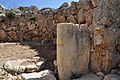
Building these huge temples was an incredible achievement. Remember, the wheel had not been invented yet! Also, the people on Malta did not have metal tools. Archaeologists have found small, round stones nearby. They think these stones were used like ball bearings to help move the enormous stone blocks. These blocks were needed to build the temples.
The southern temple stands about 6 meters (20 feet) tall. At the entrance, there is a large stone block with a hollow space. Some people think this was a place where worshippers would wash themselves. This washing would be a way to purify themselves before entering the temple. Inside the five apses, there are several altars. Researchers have found animal bones here. This suggests that animals might have been offered as part of the ceremonies.
Discovering and Protecting Ġgantija
_Voyage_en_Italie,_en_Si,_RP-T-00-494-13A.jpg)

People living on Gozo and travelers knew about the temples for a long time. In the late 1700s, an artist named Jean-Pierre Houël drew a very accurate map of the site. He did this even before any digging had been done!
In 1827, a man named Col. John Otto Bayer had the site cleared. Sadly, the soil and other remains were lost. They were not properly studied. Luckily, an artist named Charles Frederick de Brocktorff painted the site just before it was cleared. His paintings show us what it looked like back then.
After this clearing, the ruins started to fall apart. In 1925, the temples were put on a list of important ancient sites. The land was privately owned until 1933. Then, the Government of Malta bought it to protect it for everyone. The Museums Department started serious archaeological work in the 1930s and 1950s. Their goal was to clear, protect, and study the ruins.
The Ġgantija temples were recognized as a UNESCO World Heritage Site in 1980. In 1992, UNESCO decided to include five other similar temples in Malta and Gozo. The listing was then renamed "the Megalithic Temples of Malta."
In the 2000s, the temples and the area around them were restored. In 2011, special walkways were put inside the temple. These walkways help protect the ancient floors. A new heritage park was also opened in 2013. This park helps visitors learn more about these amazing ancient structures.
Gallery
-
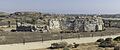
Ġgantija Temple
-

Stone spheres found at Ġgantija. Scholars suggest these were used to transport the enormous stone blocks for the temples.
-
.
Map of the Ġgantija temples
-
Possible Eternal flame in the south complex


See also
- Megalithic Temples of Malta
- Ħaġar Qim
- Hypogeum of Ħal-Saflieni
- List of megalithic sites
- Mnajdra
- Tarxien Temples
