
Ōtaki, Chiba facts for kids
Quick facts for kids
Ōtaki
大多喜町
|
|||
|---|---|---|---|
|
Town
|
|||

Ōtaki Castle
|
|||
|
|||

Location of Ōtaki in Chiba Prefecture
|
|||

Ōtaki
Location in Japan
|
|||
| Country | |||
| Region | Kanto | ||
| Prefecture | Chiba Prefecture | ||
| District | Isumi District | ||
| Area | |||
| • Total | 129.87 km2 (50.14 sq mi) | ||
| Population
(December 1, 2015)
|
|||
| • Total | 9,676 | ||
| • Density | 74.5/km2 (193/sq mi) | ||
| Time zone | UTC+9 (Japan Standard Time) | ||
| - Tree | Sakura | ||
| Phone number | 0470-82-2111 | ||
| Address | 93 Ōtaki, Ōtaki-machi, Chiba-ken 298-0292 | ||


Ōtaki (大多喜町, Ōtaki-machi) is a charming town located in the Isumi District of Chiba Prefecture, Japan. It sits right in the middle of the Bōsō Peninsula. This town has a rich history, especially because it was once home to Honda Tadakatsu, a famous general during Japan's Edo period (from 1603 to 1868). He built a very important building here: Ōtaki Castle.
As of December 2015, Ōtaki had a population of about 9,676 people. The town covers a total area of 129.87 square kilometers (about 50.14 square miles).
Contents
Geography and Nature
Ōtaki is located in the central part of the Bōsō Peninsula. This area is known for its beautiful natural scenery.
Hills, Mountains, and Forests
The town of Ōtaki is surrounded by many hills and small mountains. A large part of the town, about 70%, is covered by thick forests. This makes Ōtaki a great place for nature lovers.
Rivers Flowing Through Town
Two important rivers flow through Ōtaki. These are the Isumi River and the Yōrō River. They add to the natural beauty of the area.
Neighboring Towns and Cities
Ōtaki shares its borders with several other towns and cities. These include:
- Ichihara
- Kimitsu
- Katsuura
- Kamogawa
- Isumi City
- Mutsuzawa
- Chōnan
Ōtaki Castle: A Historical Landmark
One of the most famous places in Ōtaki is Ōtaki Castle. It has a long and interesting history.
Building the Original Castle
The original Ōtaki Castle was built by Honda Tadakatsu in 1590. He chose a hill as the perfect spot for it. Many samurai warriors and citizens built their homes around the base of the castle. This created a lively town below the castle walls.
Castle's Fate and Rebuilding
Sadly, the original castle was destroyed by fire in 1842. However, a new replica (which means a very accurate copy) of the castle was built in 1975. Today, you can visit this rebuilt castle. Inside, there is a small museum where you can learn more about the castle's history and the area.
Getting Around Ōtaki
Ōtaki has different ways to travel, making it easy to explore the town and its surroundings.
Railways for Travel
You can travel by train using these railway lines:
- Isumi Railway
- Kominato Railway
Main Roads for Driving
If you prefer to travel by car, Ōtaki is connected by important national roads:
- Japan National Route 297: This road can take you to Ichihara or Tateyama.
- Japan National Route 465: This road leads to Mobara or Futtsu.
Images for kids
-

Isumi Railway - Isumi Line
-
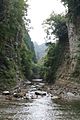
Yōrō Ravine

See also
 In Spanish: Ōtaki (Chiba) para niños
