
1888 North Canterbury earthquake facts for kids

|
|
| Local date | 1 September 1888 |
|---|---|
| Local time | 04:10 |
| Magnitude | 7.0–7.3 |
| Depth | 12 km |
| Epicenter | 42°36′S 172°24′E / 42.6°S 172.4°E |
| Areas affected | South Island New Zealand |
| Casualties | No fatalities |
The 1888 North Canterbury earthquake happened early in the morning on September 1, 1888. It struck at 4:10 am after some smaller shakes the night before. The earthquake's center was in the North Canterbury area of New Zealand's South Island. This spot was about 35 kilometers west of Hanmer Springs.
In Christchurch, which is about 100 kilometers southeast, the ground shook for 40 to 50 seconds. Scientists believe the earthquake was quite strong, with a magnitude between 7.0 and 7.3. Many farm buildings near the center were badly damaged. The very top part of the ChristChurch Cathedral spire, about 7.8 meters tall, fell off. This earthquake was special because it was the first time people saw land move mostly sideways during an earthquake.
What Caused the 1888 Earthquake?

New Zealand sits on the edge of two huge pieces of the Earth's crust called plates. These are the Australian plate and the Pacific plate. These plates are always moving and pushing against each other.
- In the South Island, most of this plate movement happens along a big fault called the Alpine Fault. A fault is like a giant crack in the Earth's crust. The Alpine Fault is a "strike-slip" fault, meaning the land on either side moves sideways past each other.
- In the North Island, the plates mostly move under each other in a process called subduction.
The 1888 earthquake happened on the Hope Fault. This fault is part of a group of faults called the Marlborough Fault System. These faults help transfer the movement between the plates in the northern part of the South Island. A geologist named Alexander McKay studied the area after the earthquake. He saw that farm fences had moved sideways by 1.5 to 2.6 meters along the fault line. He was the first person to connect this sideways movement directly to an earthquake.
How the Earthquake Damaged Buildings and Land

The earthquake caused a lot of damage in the North Canterbury region. Buildings in the Hope Valley and Hanmer areas were hit especially hard. There were also landslides where the ground was loose. Cracks up to 30 centimeters wide appeared in the ground.
In Christchurch, the top 7.8 meters of the Cathedral's spire fell down. Many houses had minor damage, like broken chimneys. The Durham Street Methodist Church, one of Christchurch's first churches made of stone, also had some damage to its stonework. The Christchurch Normal School was affected too, with chimneys falling and ceilings cracking.
The northern and northwestern parts of Christchurch saw the most damage. This was probably because the ground there was soft and peaty, which can make shaking worse.
Images for kids
-
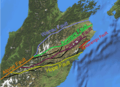
Map of the Marlborough Fault System showing location of the Hope Fault
-
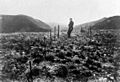
This surveyor stands at a fence that crosses the Hope Fault near Glynn Wye Station. The fence, originally straight, has been kinked by the sideways movement of the land.
