1968 Inangahua earthquake facts for kids
| UTC time | 1968-05-23 17:24:18 |
|---|---|
| ISC event | 822588 |
| USGS-ANSS | ComCat |
| Local date | 24 May 1968 |
| Local time | 5:24 am NZST (UTC+12) |
| Magnitude | 7.1 Mw |
| Depth | 12 km (7.5 mi) |
| Epicenter | 41°46′S 172°02′E / 41.76°S 172.04°E |
| Areas affected | New Zealand |
| Max. intensity | X (Very Destructive) |
| Peak acceleration | ~0.6 g |
| Casualties | 3 dead, 14 injured |
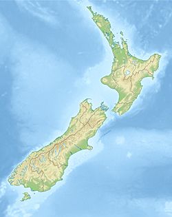
The 1968 Inangahua earthquake was a very strong earthquake that hit New Zealand on May 24, 1968. It happened near the small town of Inangahua Junction, about 25 kilometres (16 mi) west of Murchison. The earthquake struck early in the morning, at 5:24 am.
This earthquake was very powerful, measuring 7.1 on the moment magnitude scale. It was also quite shallow, at only 12 kilometres (7.5 mi) deep. Shallow earthquakes can cause more damage on the surface. Sadly, three people died and 14 others were injured. This made it one of the deadliest earthquakes in New Zealand's recorded history. Many smaller earthquakes, called aftershocks, followed the main quake. Fifteen of these were magnitude 5 or stronger within a month.
Contents
Why Earthquakes Happen in New Zealand
New Zealand is located on the edge of two huge pieces of the Earth's crust, called tectonic plates. These are the Indo-Australian Plate and the Pacific Plate. These plates are always moving, but they often get stuck. When they finally slip, it causes an earthquake.
In the South Island, most of this plate movement happens along a big fault line called the Alpine Fault. A fault is like a crack in the Earth's crust. The 1968 Inangahua earthquake happened along the northern part of this Alpine Fault. It was a typical earthquake for this area.
How the Earthquake Caused Damage
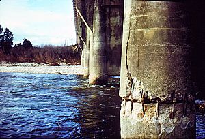
The earthquake caused a lot of destruction, especially to roads and bridges. Many years of hard work improving State Highway 6 in the Inangahua and Buller Gorge areas were ruined.
Roads and Bridges Destroyed
In one 50 kilometres (31 mi) section of the Buller Gorge road, there were over 50 blockages. These were caused by huge landslides or parts of the road collapsing into the gorge. More than 50 bridges were also damaged or completely destroyed. The earthquake even derailed two goods trains and damaged over 100 kilometres (62 mi) of railway track.
All the roads leading into and out of Inangahua were blocked by landslides. The town's electricity and phone lines were cut off. Many water pipes were also broken beyond repair.
Damage to Nearby Towns
Other towns on the West Coast felt the earthquake strongly. In Greymouth, Westport, and Reefton, more than two-thirds of the chimneys were damaged.
People Affected by the Quake
The earthquake tragically led to the deaths of three people. At Whitecliffs, a large rock face fell onto a farmhouse. This killed Mrs. Jackson instantly and seriously injured her visiting mother, Mrs. Blackmore, who later died. Another man died near Greymouth when his car hit a damaged part of the road.
Sadly, three more men died a few days later, on May 29. They were in a helicopter that crashed after hitting power lines. They were Post Office workers helping to fix things after the quake.
Landslides and River Danger
The earthquake and its many aftershocks caused many landslides in the mountains nearby. One huge landslide blocked the Buller River upstream from Inangahua. The river water began to rise, backing up for 7 kilometres (4.3 mi). The water level rose 30 metres (98 ft) higher than normal.
People worried that if this natural dam burst, it would flood Inangahua. It could also flood the much larger town of Westport, which is further downstream. As a safety measure, about 10,000 people were moved to safer areas. Luckily, the river eventually flowed over the landslide debris and slowly wore it down. This prevented a major flood.
Life After the Earthquake
Inangahua never fully recovered from the earthquake. Many people who lived there never returned to their homes. Some stayed in nearby towns like Reefton, while others moved away completely. It took months, and sometimes even years, to repair the damaged buildings. However, the railway line was fully fixed because it was a very important route.
After the earthquake, the area faced tough times. People moved away because they were scared of more aftershocks. There were fewer jobs, and fewer children attended school. Shops had fewer customers, and more "Help Wanted" signs appeared. The area later went through a difficult economic period.
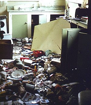
The earthquake had a big impact on the local people. Children were upset and unsettled by the sudden changes in their lives. Many had to go to Reefton School for a while because Inangahua School was too damaged to use. One teacher asked students to draw pictures of their experiences. One boy drew a broken house with rain falling on it, writing "After the earthquake it rained." The rain made it even harder to help people and clean up the town. Many families lost everything they owned. They received help from groups like the Red Cross, getting supplies and support.
|
 | John T. Biggers |
 | Thomas Blackshear |
 | Mark Bradford |
 | Beverly Buchanan |


