
2016 Kumamoto earthquakes facts for kids

A destroyed house in Kumamoto
|
|

United States Geological Survey shake map for the April 16 earthquake; a maximum Mercalli intensity scale value of 8.8 was observed just east of Kumamoto City.
|
|

|
|
| UTC time | 2016-04-15 16:25:06 |
|---|---|
| ISC event | 610289055 |
| USGS-ANSS | ComCat |
| Local date | April 16, 2016 |
| Local time | 01:25 JST (UTC+9) |
| Magnitude | 7.0 Mw 7.3 MJMA |
| Depth | 10 km |
| Epicenter | 32°46′55.2″N 130°43′33.6″E / 32.782000°N 130.726000°E |
| Fault | Futagawa-Hinagu fault zone |
| Type | Strike-slip |
| Areas affected | Kumamoto Prefecture, Kyushu, Japan |
| Max. intensity | JMA 7 |
| Peak acceleration | 1.61 g (foreshock) 1580 Gal (foreshock) 1.83 g (mainshock) 1791 Gal (mainshock) |
| Foreshocks | 6.2 Mw, April 14, 2016 12:26:36 (UTC), 21:26:36 (JST) |
| Casualties | 277 dead, 2,809 injured (including indirect deaths) |
The 2016 Kumamoto earthquakes were a series of strong earthquakes that hit the Kyushu region of Japan. The main earthquake, called the mainshock, happened on April 16, 2016. It had a magnitude of 7.0. Two days earlier, on April 14, a strong foreshock with a magnitude of 6.2 shook the area. Both quakes happened about 10 to 11 kilometers (6 to 7 miles) deep underground.
Sadly, these earthquakes led to 277 deaths and injured 2,809 people. Some deaths were directly from the shaking. Others were due to health problems made worse by the difficult conditions after the quakes, like during evacuations. This series of earthquakes was the deadliest in Japan since the 2011 Tōhoku earthquake and tsunami, until the 2024 Noto earthquake.
The earthquakes caused a lot of damage in Kumamoto Prefecture and Ōita Prefecture. Many buildings collapsed, and some even caught fire. Over 44,000 people had to leave their homes for safety.
Contents
Why Earthquakes Happen in Kumamoto
Kumamoto Prefecture is located in an area where the Earth's crust is very active. It sits near the southern part of the Japan Median Tectonic Line, which is Japan's longest fault line. A fault line is a crack in the Earth's crust where two large sections of rock, called tectonic plates, meet and move.
In this area, several active fault lines come together. The 2016 earthquakes happened along two main faults: the Hinagu Fault (about 81 kilometers long) and the Futagawa Fault (about 64 kilometers long). During the main earthquake, a 27-kilometer section of the Futagawa Fault moved about 3.5 meters. This movement caused the ground to shake.
Mount Aso's Activity
On April 16, around 8:30 AM, Mount Aso, a nearby volcano, had a small eruption. Ash rose about 100 meters (330 feet) into the air. Experts confirmed that this eruption was not directly caused by the earthquakes. Mount Aso had already been active before the earthquakes. It was under a warning level from the Japan Meteorological Agency since late 2015.
The Earthquakes
.svg)
Earthquakes are measured in two main ways: magnitude and intensity. Magnitude tells us the total energy released by the earthquake. Intensity describes how strongly the shaking was felt in different places.
The April 14 Foreshock
The first strong earthquake, called a foreshock, happened on April 14, 2016, at 9:26 PM Japan Standard Time. It had a magnitude of 6.2. The earthquake's center was about 12 kilometers (7.5 miles) deep, near Mount Kinpo. However, the town of Mashiki was hit the hardest.
This foreshock was felt far away, from Shimonoseki in the north to Kirishima in the south. In the next two days, more than 140 smaller earthquakes, called aftershocks, followed. One of these aftershocks was as strong as magnitude 6. This was the first time an earthquake on the island of Kyushu reached an intensity of 7 on Japan's seismic scale.
| Intensity | Prefecture | Location |
|---|---|---|
| 7 | Kumamoto | Mashiki |
| 6- | Kumamoto | Kumamoto (Higashi-ku, Nishi-ku, Minami-ku), Tamana, Uki, Nishihara |
The April 16 Mainshock
The main earthquake struck on April 16, 2016, at 1:25 AM Japan Standard Time. It was much stronger, with a magnitude of 7.0. This quake happened under the Higashi Ward of Kumamoto City. It caused even more damage to areas already affected by the foreshock.
Strong shaking and damage were also reported in Ōita Prefecture, as far east as Beppu. People in Busan, South Korea, even felt the tremors. A tsunami advisory was briefly issued for coastal areas, but it was lifted less than an hour later. This meant that large, dangerous waves were not expected.
| Intensity | Prefecture | Location |
|---|---|---|
| 7 | Kumamoto | Nishihara, Mashiki |
| 6+ | Kumamoto | Minamiaso, Kumamoto (Chūō-ku, Higashi-ku, Nishi-ku), Kikuchi, Uto, Uki, Koshi, Ozu, Kashima |
| 6- | Kumamoto | Aso, Kumamoto (Minami-ku, Kita-ku), Yatsushiro, Tamana, Misato, Nagomi, Kikuyo, Mifune, Yamato, Hikawa, Kamiamakusa, Amakusa |
| Oita | Beppu, Yufu |
Aftershocks Continue
After the mainshock, many more aftershocks continued to shake the region. These smaller quakes can still cause damage to already weakened buildings. Here is a list of some of the stronger aftershocks that happened:
| Japan Time | Magnitude | Intensity | Comment |
|---|---|---|---|
| 2016-04-14 21:26 | Mj6.5, Mw6.2 | 7 | Foreshocks |
| 2016-04-14 22:07 | Mj5.8 | 6- | |
| 2016-04-15 00:03 | Mj6.4 | 6+ | |
| 2016-04-16 01:25 | Mj7.3, Mw7.0 | 7 | Mainshock |
| 2016-04-16 01:45 | Mj5.9 | 6- | Aftershocks |
| 2016-04-16 03:03 | Mj5.9 | 5+ | |
| 2016-04-16 03:55 | Mj5.8 | 6+ | |
| 2016-04-18 20:41 | Mj5.8 | 5+ | |
| 2016-04-19 17:52 | Mj5.5 | 5+ |
Damage and Impact
The Kumamoto earthquakes caused widespread damage across the region. Many homes, buildings, and important structures were affected.
Impact of the April 14 Foreshock
The first strong earthquake on April 14 caused nine deaths and injured over 1,100 people. Famous landmarks like Kumamoto Castle suffered damage to its roof and outer walls. Train services, including the high-speed Kyushu Shinkansen, were stopped after a train derailed.
About 44,000 people had to leave their homes. At least 19 houses completely collapsed. Stores saw merchandise fall from shelves. Fires broke out in some areas, and landslides damaged roads.
Impact of the April 16 Mainshock
The main earthquake on April 16 caused even more destruction. Sadly, 277 people died, and 2,809 were injured. This number includes deaths related to the disaster, often from existing health issues made worse by the stress or difficult conditions during evacuation.
Across Kumamoto Prefecture, over 8,600 houses were completely destroyed. More than 34,000 homes were partly damaged. Many public buildings and other structures also suffered damage. In Ōita Prefecture, three people died, and 34 were injured. Many houses there were also damaged. Other prefectures like Fukuoka Prefecture, Saga Prefecture, and Miyazaki Prefecture also reported injuries and damaged homes.
Infrastructure and Services
After the mainshock, all of Kumamoto City lost its water supply. Residents of Nishihara Village were evacuated because of worries about a nearby dam. Kumamoto Airport was closed to all flights except emergency ones. The Kyushu Shinkansen train service was again suspended.
Over 1,000 buildings were seriously damaged, with 90 completely destroyed. A 500-bed hospital in Kumamoto City had to evacuate all its patients because its foundation was damaged. A natural gas leak also led to gas supplies being turned off in many homes.
Landslides and Roads
The earthquakes caused many landslides in the mountains of Kyushu. These landslides made roads impassable. The Great Aso Bridge, part of Japan National Route 325, collapsed into the Kurokawa River. A large rockslide blocked a four-lane expressway near the fallen bridge.
Historical Sites Damaged
Several important historical sites were badly damaged. The Aso Shrine saw its main gate (called a rōmon) and worship hall (haiden) completely collapse. Both were officially recognized as Important Cultural Properties. Kumamoto Castle, another Important Cultural Property, also had significant damage to its roof, walls, and decorative ornaments. Other historic buildings, like Janes' Residence from 1871, were also destroyed.
Economic Costs
The earthquakes caused a lot of financial damage. Early estimates suggested the total cost could be between $5.5 billion and $7.5 billion. Insurance companies paid out about $3.2 billion for damaged homes in the first half of 2016.
Aftermath and Recovery
After the earthquakes, police in Kumamoto and Ōita Prefectures received hundreds of calls for help. More than 91,700 people were evacuated from their homes. The Japan Self-Defense Forces sent over 15,000 soldiers to help with rescue and recovery efforts.
By April 16, over 44,000 people were in shelters. Prime Minister Shinzō Abe ordered 3,000 personnel to assist local authorities. By April 18, the number of people needing shelter grew to 180,000. Rescue teams continued to search for missing people in areas affected by landslides.
Images for kids
-
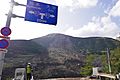
The Great Aso Bridge in Minamiaso collapsed into the Kurokawa River due to a landslide
-
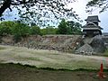
The north-west Inui Turret and wall of Kumamoto Castle.
-
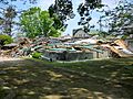
The ruins of the historic Janes' Residence
-
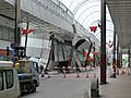
The damaged Sunlive Kengun in the pedestrian arcade in downtown Kumamoto.


See also
 In Spanish: Terremoto de Kumamoto de 2016 para niños
- 1889 Kumamoto earthquake
- List of earthquakes in 2016
- List of earthquakes in Japan
