A72 road facts for kids
Quick facts for kids
A72 road |
||||
|---|---|---|---|---|
|
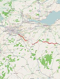
Click map to enlarge
|
||||
| Route information | ||||
| Length | 63 mi (101 km) | |||
| Major junctions | ||||
| West end | Hamilton 55°46′40″N 4°03′12″W / 55.7778°N 4.0532°W |
|||
| East end | Galashiels 55°37′08″N 2°48′44″W / 55.6189°N 2.8121°W |
|||
| Location | ||||
| Primary destinations: |
Hamilton, Lanark, Peebles, Galashiels | |||
| Road network | ||||
|
||||
The A72 road is an important route in Scotland. It connects the town of Hamilton in South Lanarkshire with Galashiels in the Scottish Borders. This road stretches for over 100 kilometers (about 60 miles). It generally travels southeast, following the beautiful valleys of the River Clyde and River Tweed. Along its way, the A72 passes through several towns. These include Larkhall, Lanark, Biggar, and Peebles.
Contents
The A72 Road: Connecting Scotland's Towns
The A72 road helps people travel across a large part of southern Scotland. It's a key link between different communities. The road's path follows two major rivers. This makes for some very scenic drives.
Journey Through the Clyde Valley
The A72 road begins in Hamilton. It starts where it meets the A724 road. For a while, it runs next to the M74 motorway. It also follows the path of an older road, the A74.
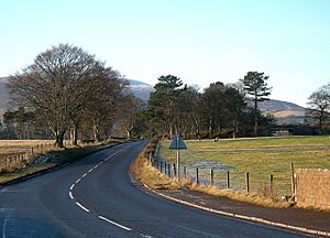
Then, the road goes down into the green Clyde Valley. It passes around the town of Larkhall. As it follows the River Clyde, the road has some twists and turns. It can be a bit challenging to drive in places. Finally, it meets the A73 road just north of Lanark.
From Lanark to the Countryside
Through the town of Lanark, the A72 road actually shares its path with the A73. After Lanark, just before a village called Symington, the road becomes the A72 again.
Here, it meets the main A702. This road connects Edinburgh to Abington. The part of the A72 that goes through Symington is quite narrow.
High Roads and Scenic Views

For about 5 kilometers (3 miles), the A72 road again follows the A702. This happens as it goes through the town of Biggar. After Biggar, the A72 enters the small village of Skirling.
From Skirling, the road climbs up onto higher, open moorland. This part of the road is known for its high elevation. It can have poor weather and many winding turns. Drivers need to be extra careful here.
Reaching the Scottish Borders
For the last 10 kilometers (6 miles) of the A72, it is a secondary route. It runs alongside the A701 road. Just south of a place called Blyth Bridge, it meets the A721.
A short distance later, the A72 leaves the A701. It then climbs up to a high flat area. After that, it goes down into the valley of the River Tweed near Stobo. The A72 then follows the River Tweed for the rest of its journey.
The road passes through the towns of Peebles, then Innerleithen, and Walkerburn. It continues towards Galashiels. The A72 finally ends at a junction with the A7 road. The A7 then leads into the Galashiels Ring Road.
 | Ernest Everett Just |
 | Mary Jackson |
 | Emmett Chappelle |
 | Marie Maynard Daly |


