
Aarburg facts for kids
Quick facts for kids
Aarburg
|
||
|---|---|---|

Aarburg old town
|
||
|
||

Aarburg
Location in Switzerland

Aarburg
Location in Canton of Aargau
|
||
| Country | Switzerland | |
| Canton | Aargau | |
| District | Zofingen | |
| Area | ||
| • Total | 4.41 km2 (1.70 sq mi) | |
| Elevation
(Städtchen)
|
397 m (1,302 ft) | |
| Population
(Dec 2020 )
|
||
| • Total | 8,577 | |
| • Density | 1,944.9/km2 (5,037/sq mi) | |
| Demonym(s) | German: Aarburger(in) | |
| Postal code |
4663
|
|
| Surrounded by | Oftringen, Olten (SO), Rothrist, Starrkirch-Wil (SO) | |

Aarburg is a historic town and a municipality in Switzerland. It is located in the Aargau canton, within the Zofingen district.
This small town sits in the southwest Aargau region. It is found in a narrow part of the Aare river valley. The Wigger river also joins the Aare here. Aarburg is at a key meeting point for important travel routes in Switzerland.
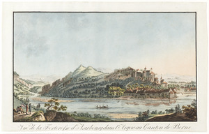
The most famous landmark is Aarburg Castle. It is one of Switzerland's largest castles. The castle and a church on a rocky hill give Aarburg its unique look.
The official language in Aarburg is German. However, most people speak a local Swiss German dialect.
Contents
History of Aarburg

Ancient Times and Early Settlement
A long time ago, in Roman times, a road passed through Aarburg. This road connected the Olten area with central Switzerland. In the 20th century, workers building a factory found a collection of old coins. These coins were from the time of Emperor Tetricus I. They were likely buried around 284 CE during a time of invasions.
The Castle's Beginnings
We don't know exactly when Aarburg Castle was built. It sits on a rocky hill. The first time it was written about was in 1123. Back then, it was called Areburc. The castle belonged to the Frohburg family. They used it to rule the area known as the Bailiwick of Aarburg. This area is now the western part of Zofingen county.
In 1299, the Frohburg family sold the castle to the Habsburg family. By 1330, the small settlement at the foot of the castle was clearly called a town. Digs by archaeologists show that the town was probably started around 1312.
Growth and Trade
Aarburg was located between the bigger cities of Olten and Zofingen. These cities were only four kilometers apart. Because of this, Aarburg could not grow much as a trading center. It stayed a small town.
The people of Aarburg mostly earned money from taxes on goods. These goods traveled along the Gotthard Pass trade route. In 1361, a small harbor was built on the Aare river. River boat traffic became very important for the town's economy. This lasted until the 16th and 17th centuries.
Bernese Control and Expansion
On April 14, 1415, the town was captured by Bern after a short fight. In 1416, the castle became the home of Bern's local governor, called a bailiff.
Under Bern's control, the castle was made much bigger. It became a strong fortress in the 16th and 17th centuries. This was done to protect the alliance between Bern and Zurich. These were two important cities that followed the Reformed faith. The fortress helped guard them from attacks by their Catholic neighbors.
French Rule and Modern Changes
On May 4, 1798, French forces took over the town and fortress without a fight. The Aarburg district was then broken up. The French moved the local government duties to Zofingen.
In 1804, the new Canton of Aargau took over the fortress. At first, it was used as a jail. Since 1893, the castle has been a school run by the canton.
A huge fire on May 4, 1840, destroyed much of the town and its church. Sixty-eight families lost their homes. The village was rebuilt, but without its main defenses. A new church was built on the rocky hill near the castle. It was constructed between 1842 and 1845 in a new Gothic style.
The first textile factory opened in Aarburg in 1824. The railway station opened on July 9, 1856. This connected Aarburg to other cities like Aarau, Olten, and Zofingen. Another railway line opened in 1857, later going to Bern. This made Aarburg an important industrial town. In the second half of the 20th century, the town's population doubled. This was due to a new highway built nearby.
Geography of Aarburg

Aarburg covers an area of about 4.42 square kilometers (1.71 sq mi). About 19.2% of this land is used for farming. Forests cover 31.0% of the area. Buildings and roads make up 45.7% of the land. Rivers and lakes cover 3.8%.
The municipality is in the Zofingen District. It lies along the Aare river, where it forms a whirlpool called the Aarewaage. Aarburg is at the foot of Aarburg hill and Aarburg Castle. The town includes the old village and industrial areas built in the 19th and 20th centuries, along the river.
Aarburg's Coat of Arms
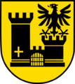
The coat of arms for Aarburg shows a black castle on a gold background. The castle has a closed gate. The right tower has a gold cross on top. The left tower has a black eagle with its wings spread.
People and Population
Aarburg has a population of about 8,700 people. As of June 2009, about 39.0% of the people living here were foreign nationals. Over ten years (1997–2007), the population grew by 3.8%.
Most people in Aarburg speak German (77.9%). Italian is the second most common language (6.0%). Serbo-Croatian is the third most common (3.7%).
In 2008, about 10.7% of the population were children aged 0-9. Teenagers aged 10-19 made up 11.9%. Adults aged 20-59 made up a larger portion. Older adults aged 60 and above made up about 19.3% of the population.
The average home had 2.4 people living in it in 2000. About 38.9% of homes were owned by the people living in them.
The historical population of Aarburg has changed over time:
| Historical population | ||
|---|---|---|
| Year | Pop. | ±% |
| 1764 | 569 | — |
| 1798 | 1,029 | +80.8% |
| 1850 | 1,700 | +65.2% |
| 1900 | 2,300 | +35.3% |
| 1970 | 5,943 | +158.4% |
| 2000 | 6,263 | +5.4% |
Important Landmarks and Sights

Several places in Aarburg are listed as important Swiss heritage sites. These include the ruins of the Froburg gallows, the old Post hotel, and Aarburg Castle. The entire village of Aarburg is also recognized as a Swiss heritage site.
Exploring the Old Town
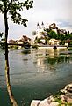
The old town of Aarburg is shaped like a triangle. It lies between the river and a wedge-shaped rock formation. This rock acts as a natural barrier on two sides. The houses are built around a similar wedge-shaped town square. The town's defenses on the north side were not rebuilt after the big fire in 1840.
The Aarburg fortress stands tall over the old town. It is on a long, narrow rocky hill. The fortress was built in the early 12th century. It was made much stronger when Bern controlled it. Today, this fortress is a nationally recognized cultural treasure. It now serves as a youth center.
You can take public tours of the fortress. These tours happen at 2:00 PM on Saturdays during spring and summer (April to October). There is a fee for people aged 16 and older. You can also arrange private tours all year by contacting the youth center. The Aarburg Historic Museum is open on the second and fourth Sunday mornings of each month.
The Reformed Church
Between the fortress and the old town, on a flat area, is the Reformed church. It was built from 1842 to 1845. It has a new Gothic style with two tall spires on the west side. Below the church, on the rocky hill, is the parsonage (the minister's house). It was built in 1726. Until the fire of 1840, the town gate passed through its basement.
Economy of Aarburg
In 2007, Aarburg had an unemployment rate of 3.8%. In 2005, a small number of people (15) worked in farming. There were 5 businesses in this sector.
Many people (928) worked in the manufacturing sector. There were 50 businesses in this area. The largest number of people (1,767) worked in the service sector. This sector had 217 businesses.
In 2000, 3,233 workers lived in Aarburg. About 74.3% of them worked outside the municipality. However, 1,856 people came into Aarburg for work. There were 2,687 jobs in the municipality. About 17.4% of workers used public transport to get to work. Most (49.1%) used a private car.
Religion in Aarburg
Based on the 2000 census, about 34.2% of the people were Roman Catholic. Another 36.5% belonged to the Swiss Reformed Church. A small number (0.38%) were Old Catholics.
Education in Aarburg
In Aarburg, about 59.4% of adults (aged 25-64) have finished higher education. This means they completed either upper secondary school or a university degree.
In the 2008/2009 school year, there were 490 students in primary school. There were 170 students in secondary school. Another 109 students were attending university-level schooling.
Aarburg has a public library called Stadtbibliothek Aarburg. In 2008, the library had 8,271 books and other media. It loaned out 20,379 items that year. The library was open 230 days, for about 11 hours per week.

Transportation in Aarburg
The municipality has a railway station called Aarburg-Oftringen. It is on the Olten–Bern and Olten–Lucerne railway lines. There are regular train services to Lucerne, Langenthal, and Baden.
Notable people
- Jacques-Barthélemy Micheli du Crest (1690 – 1766) was a military engineer, physicist, and mapmaker. He spent his later years as a political prisoner in Aarburg Castle.
Images for kids
-
Aarburg old town
-
Coat of arms of Aarburg
-
Flag of Aarburg

See also
 In Spanish: Aarburg para niños
