
Aberchirder facts for kids
Quick facts for kids Aberchirder
|
|
|---|---|
 |
|

Aberchirder
|
|
| Population | 1,170 (2020) |
| OS grid reference | NJ624522 |
| Council area | |
| Lieutenancy area | |
| Country | Scotland |
| Sovereign state | United Kingdom |
| Post town | HUNTLY |
| Postcode district | AB54 |
| Dialling code | 01466 |
| Police | Grampian |
| Fire | Grampian |
| Ambulance | Scottish |
| EU Parliament | Scotland |
| UK Parliament |
|
| Scottish Parliament |
|
Aberchirder, known locally as Foggieloan or Foggie, is a village in Aberdeenshire, Scotland. It is located on the A97 road, about six miles west of Turriff.
Contents
What Does the Name Aberchirder Mean?
The name Aberchirder was first recorded around 1204 as Aberkerdour. It means 'mouth of the Chirder'. The first part, aber, is an old Pictish word meaning 'river mouth'. The second part, Chirder, is a stream name. It comes from Gaelic words: ciar meaning 'dark, brown' and dobhar meaning 'water'. So, the name tells us about a dark or brown stream joining a larger river.
How Did Aberchirder Start?
The village of Aberchirder was founded in 1764. It was created by Alexander Gordon, who was the 5th Laird of Auchintoul. For a while, its official name was Foggieloan. This name came from a small farm community that was on the same spot.
Why Was it Called Foggieloan?
People are not entirely sure how the name Foggieloan began. One idea is that there was a marshy area nearby called Foggieloan Moss. This name might come from two Gaelic words: foidh (peat moss) and lòn (meadow). So, Foggieloan could mean 'peaty' or 'boggy meadow'.
When Did the Name Change?
In 1823, the village's name changed to Aberchirder. This change was made by the landowner, John Morison. He was a Member of Parliament. He named it after the old Thanes of Aberkerdour from the 13th century. They lived at Kinnairdy Castle, which is about two miles southwest of the village.
How Was the Village Designed?
Aberchirder was a planned community. This means it was carefully designed before it was built. The village was laid out in a grid pattern around a central square. The houses were mostly single-storey and made of stone. They faced the streets, and each had a long garden behind it. These gardens were meant to help families grow their own food.
Alexander Gordon hoped Aberchirder would become a busy industrial village. He even built a small linen factory. This factory made fine linen tablecloths and a fabric called wincey. By the late 1800s, the village had grown. Wealthier people built bigger houses. There were also several churches for different religious groups.
What About the Cold War Bunker?
In 1960, a small monitoring bunker was opened in Aberchirder. It was built by the Royal Observer Corps. This bunker was designed to be used if there was a nuclear attack. It closed in 1991 and is still there today.
How to Get Around Aberchirder
The village has bus services that connect it to other towns. The 301 bus goes between Huntly and Macduff. The 303 bus travels between Huntly and Turriff.
Images for kids
-
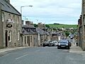
Main Street in Aberchirder, showing some of the village's buildings.

