
Aberdeen, Idaho facts for kids
Quick facts for kids
Aberdeen, Idaho
|
|
|---|---|

Location of Aberdeen in Bingham County, Idaho
|
|
| Country | United States |
| State | Idaho |
| County | Bingham |
| Incorporated | 1907 |
| Area | |
| • Total | 1.03 sq mi (2.67 km2) |
| • Land | 1.03 sq mi (2.67 km2) |
| • Water | 0.00 sq mi (0.00 km2) |
| Elevation | 4,403 ft (1,342 m) |
| Population
(2020)
|
|
| • Total | 1,756 |
| • Estimate
(2022)
|
1,832 |
| • Density | 1,779.0/sq mi (687.0/km2) |
| Time zone | UTC–7 (Mountain (MST)) |
| • Summer (DST) | UTC–6 (MDT) |
| ZIP Code |
83210
|
| Area code(s) | 208 and 986 |
| FIPS code | 16-00100 |
| GNIS feature ID | 2409654 |
Aberdeen is a city located in Bingham County, Idaho, in the United States. It was named after the city of Aberdeen in Scotland. In 2020, about 1,756 people lived there.
Contents
Exploring Aberdeen's Location and Climate
Aberdeen is a city in Idaho. It covers an area of about 1.03 square miles (2.67 square kilometers). All of this area is land, meaning there are no large lakes or rivers within the city limits.
Understanding Aberdeen's Weather Patterns
Aberdeen has a semi-arid steppe climate. This means it's usually dry, but not a desert. It gets enough rain to support some grasses and shrubs.
The weather in Aberdeen can be very extreme. The hottest temperature ever recorded was 104°F (40°C). This happened on three different dates: July 21, 1931, July 28, 1934, and July 23, 2006. The coldest temperature ever recorded was a chilly -42°F (-41°C) on January 19, 1922.
| Climate data for Aberdeen, Idaho, 1991–2020 normals, extremes 1914–present | |||||||||||||
|---|---|---|---|---|---|---|---|---|---|---|---|---|---|
| Month | Jan | Feb | Mar | Apr | May | Jun | Jul | Aug | Sep | Oct | Nov | Dec | Year |
| Record high °F (°C) | 56 (13) |
63 (17) |
76 (24) |
86 (30) |
96 (36) |
103 (39) |
104 (40) |
103 (39) |
100 (38) |
89 (32) |
73 (23) |
67 (19) |
104 (40) |
| Mean maximum °F (°C) | 45.2 (7.3) |
50.2 (10.1) |
64.9 (18.3) |
76.5 (24.7) |
84.6 (29.2) |
91.9 (33.3) |
97.8 (36.6) |
97.3 (36.3) |
91.1 (32.8) |
79.5 (26.4) |
62.8 (17.1) |
49.7 (9.8) |
99.0 (37.2) |
| Mean daily maximum °F (°C) | 32.2 (0.1) |
37.2 (2.9) |
48.3 (9.1) |
57.9 (14.4) |
67.7 (19.8) |
76.9 (24.9) |
87.1 (30.6) |
86.8 (30.4) |
76.4 (24.7) |
61.2 (16.2) |
45.1 (7.3) |
33.2 (0.7) |
59.2 (15.1) |
| Daily mean °F (°C) | 23.0 (−5.0) |
27.3 (−2.6) |
36.9 (2.7) |
44.3 (6.8) |
53.8 (12.1) |
61.4 (16.3) |
69.1 (20.6) |
67.7 (19.8) |
58.4 (14.7) |
45.8 (7.7) |
33.4 (0.8) |
23.8 (−4.6) |
45.4 (7.4) |
| Mean daily minimum °F (°C) | 13.8 (−10.1) |
17.4 (−8.1) |
25.6 (−3.6) |
30.8 (−0.7) |
39.8 (4.3) |
45.8 (7.7) |
51.1 (10.6) |
48.7 (9.3) |
40.4 (4.7) |
30.4 (−0.9) |
21.7 (−5.7) |
14.5 (−9.7) |
31.7 (−0.2) |
| Mean minimum °F (°C) | −7.1 (−21.7) |
−1.6 (−18.7) |
9.2 (−12.7) |
17.7 (−7.9) |
25.7 (−3.5) |
32.9 (0.5) |
40.3 (4.6) |
37.1 (2.8) |
27.3 (−2.6) |
15.9 (−8.9) |
3.5 (−15.8) |
−6.3 (−21.3) |
−12.5 (−24.7) |
| Record low °F (°C) | −42 (−41) |
−38 (−39) |
−22 (−30) |
−7 (−22) |
15 (−9) |
22 (−6) |
31 (−1) |
29 (−2) |
9 (−13) |
−3 (−19) |
−16 (−27) |
−32 (−36) |
−42 (−41) |
| Average precipitation inches (mm) | 0.85 (22) |
0.64 (16) |
0.85 (22) |
0.87 (22) |
1.17 (30) |
0.99 (25) |
0.41 (10) |
0.42 (11) |
0.83 (21) |
0.90 (23) |
0.66 (17) |
0.99 (25) |
9.58 (244) |
| Average snowfall inches (cm) | 7.7 (20) |
5.1 (13) |
1.8 (4.6) |
0.5 (1.3) |
0.1 (0.25) |
0.0 (0.0) |
0.0 (0.0) |
0.0 (0.0) |
0.0 (0.0) |
0.5 (1.3) |
2.0 (5.1) |
7.5 (19) |
25.2 (64.55) |
| Average precipitation days (≥ 0.01 in) | 7.9 | 6.5 | 6.1 | 6.7 | 7.5 | 5.3 | 3.6 | 3.8 | 4.8 | 5.7 | 5.7 | 8.4 | 72.0 |
| Average snowy days (≥ 0.1 in) | 5.1 | 3.6 | 1.0 | 0.4 | 0.0 | 0.0 | 0.0 | 0.0 | 0.0 | 0.2 | 1.4 | 5.5 | 17.2 |
| Source 1: NOAA | |||||||||||||
| Source 2: National Weather Service | |||||||||||||
People Living in Aberdeen: Demographics
The number of people living in Aberdeen has changed over the years. The city's population was 1,756 people in 2020. This information comes from the United States Census.
| Historical population | |||
|---|---|---|---|
| Census | Pop. | %± | |
| 1920 | 471 | — | |
| 1930 | 646 | 37.2% | |
| 1940 | 1,016 | 57.3% | |
| 1950 | 1,486 | 46.3% | |
| 1960 | 1,484 | −0.1% | |
| 1970 | 1,542 | 3.9% | |
| 1980 | 1,528 | −0.9% | |
| 1990 | 1,406 | −8.0% | |
| 2000 | 1,840 | 30.9% | |
| 2010 | 1,994 | 8.4% | |
| 2020 | 1,756 | −11.9% | |
| 2022 (est.) | 1,832 | −8.1% | |
| U.S. Decennial Census 2020 Census |
|||
Aberdeen's Population in 2020
In 2020, there were 1,756 people living in Aberdeen. There were also 741 households. A household means all the people living in one home.
Aberdeen's Population in 2010
Back in 2010, Aberdeen had 1,994 people. There were 615 households and 466 families. The city had about 1,936 people per square mile.
Most people in Aberdeen were White (60.2%). About 37.5% were from other races. Also, 54.1% of the people were Hispanic or Latino.
Many households (49.6%) had children under 18 living there. Most households (59.0%) were married couples. The average household had 3.24 people. The average family had 3.79 people.
The average age in the city was 28.1 years old. About 37.2% of residents were under 18. About 10.1% were 65 or older. The city had slightly more males (50.6%) than females (49.4%).
Education in Aberdeen: Schools and Learning Centers
Aberdeen Public Schools are part of the Aberdeen School District #58. This district includes several schools for different age groups.
- Aberdeen Elementary School
- Aberdeen Middle School
- Aberdeen High School
The University of Idaho also has a special center near Aberdeen. It's called the Aberdeen Research and Extension Center. Here, scientists and students do research, often about farming. C.J. Ward is the Superintendent of Schools for the district.
Getting Around: Transportation in Aberdeen
Aberdeen has its own small airport.
Aberdeen Municipal Airport
The Aberdeen Municipal Airport is owned by the city. It's used by the public and is located about two nautical miles (3.7 km) southwest of the main part of Aberdeen. The main part of a city is often called the central business district.
Images for kids
-
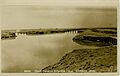
Irrigation canals in Aberdeen around 1920
_Aberdeen-Springfield_Canal_Check_Gates.jpg)
See also
 In Spanish: Aberdeen (Idaho) para niños
