Adur Estuary facts for kids
| Site of Special Scientific Interest | |
 |
|
| Area of Search | West Sussex |
|---|---|
| Interest | Biological |
| Area | 60.3 hectares (149 acres) |
| Notification | 1987 |
| Location map | Magic Map |
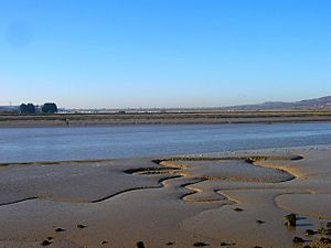
The Adur Estuary is a special natural area in West Sussex, near Shoreham-by-Sea. It covers about 62 hectares (153 acres) and is important for its wildlife. Because of its unique nature, it's called a Site of Special Scientific Interest.
A part of the estuary is a nature reserve managed by the Royal Society for the Protection of Birds (RSPB). This area is not open to the public.
The estuary has big areas of salt marsh, which are coastal wetlands flooded by tides. Plants like sea purslane and glasswort grow here. There are also muddy areas that are uncovered at low tide. These mudflats are very important for birds like ringed plovers, redshanks, and dunlin.
Contents
How the Adur Estuary Changed Over Time
The Adur Estuary has always been changing. The River Adur brings down mud and sand, and the sea moves shingle (small stones) along the coast. People have also worked hard to keep the port open.
Early Days of the Port
Long ago, the main port was at Old Shoreham. This spot is now about 1.5 kilometers (1 mile) from the sea. Boats could sail far up the Adur River, all the way to Bramber.
But over time, the river filled up with too much mud. By the 11th century, the port had to move. It moved about 1 kilometer (0.6 miles) downstream to what is now Shoreham, then called New Shoreham.
The Shifting River Mouth
In 1587, when England was getting ready for the Spanish Armada, maps showed the river's mouth. The Adur River flowed about 1 kilometer (0.6 miles) east from New Shoreham. It entered the English Channel between New Shoreham and Kingston-by-Sea. To the west, there was a wide shingle beach.
By 1648, this shingle beach had grown even longer. It stretched about 1.4 kilometers (0.9 miles) further east. By 1698, it had grown another 600 meters (656 yards). Many sandbanks also formed in the river. As the beach grew east, it became thinner. The lagoons near New Shoreham filled with mud and became marshland.
Human Efforts to Control the River
People tried to dig new channels for the river in the late 1600s and 1700s. But these new channels also filled up with mud. By 1757, the Adur River entered the sea much further east, at Aldrington. This was about 5.1 kilometers (3.2 miles) from New Shoreham.
In 1760, a big decision was made. People decided to dig a new, artificial channel at Kingston. This was to make it easier for ships to reach the port. It also helped with drainage further up the river. This new channel caused stronger tides. These tides washed over the saltmarshes on the north side of the river.
A map from 1778-1783 showed that a belt of marshland was protected by the shingle bar. This bar was wider than it is today. But the entrance to the port kept moving because of the mud and sand.
Stabilizing the Estuary
In 1818, the original 1760 channel was dug out again. Walls, groynes (structures built into the sea), and breakwaters were built to protect it. In 1821, these walls made the channel a permanent opening.
Later, in 1860, the old river channel east of Kingston was turned into a basin. Water levels there could be controlled by locks. Since about 1816, the estuary has been more stable. However, the mud and sand banks inside the estuary still shift around.
The western part of the shingle bar has gained enough material for houses to be built there. But the eastern part has slowly lost shingle. This has caused worries about the safety of the old power station at Shoreham.
Wildlife in the Adur Estuary
The muddy areas and saltmarshes of the Adur Estuary are very important. They are places where birds can feed and rest.
Birds of the Estuary
- Wildfowl: The most common wildfowl (water birds) are Eurasian teal and mallard.
- Waders: Many wading birds visit, including Northern lapwing, grey plover, common redshank, common snipe, and ruddy turnstone.
- Ringed Plovers: The estuary is especially important in winter for common ringed plovers. The number of these birds here often makes up 1% of all ringed plovers in Britain!
Other Wildlife
Next to the estuary, on the north side of the A27 road, there is a reedbed. This is a marshy area with tall grasses. Here, birds like common moorhen, Eurasian reed warbler, and sedge warbler build their nests.
Close to the car park, on an embankment, lives a large group of viviparous lizards (Zootoca vivipara).
 | Claudette Colvin |
 | Myrlie Evers-Williams |
 | Alberta Odell Jones |

