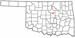
Agra, Oklahoma facts for kids
Quick facts for kids
Agra, Oklahoma
|
|
|---|---|

Location of Agra, Oklahoma
|
|
| Country | United States |
| State | Oklahoma |
| County | Lincoln |
| Area | |
| • Total | 0.39 sq mi (1.02 km2) |
| • Land | 0.39 sq mi (1.02 km2) |
| • Water | 0.00 sq mi (0.00 km2) |
| Elevation | 1,027 ft (313 m) |
| Population
(2020)
|
|
| • Total | 311 |
| • Density | 791.35/sq mi (305.27/km2) |
| Time zone | UTC-6 (Central (CST)) |
| • Summer (DST) | UTC-5 (CDT) |
| ZIP code |
74824
|
| Area codes | 539/918 |
| FIPS code | 40-00700 |
| GNIS feature ID | 2412338 |
Agra is a small town located in northern Lincoln County, Oklahoma, in the United States. In 2020, about 311 people lived there. The town's name, "Agra," comes from the word "agriculture," which means farming. This name was chosen by an early real estate developer.
Contents
History of Agra
Agra started to grow around the early 1900s. A post office opened in Agra on December 20, 1902. Isaac C. Pierce was the first postmaster, which is the person in charge of the post office.
Railroad and Town Development
A railroad line was built near Agra between 1902 and 1904. This line connected Oklahoma City to Parsons, Kansas. Two local farmers, Frank Wheeler and Sam Holder, sold their land along the railroad. An organization called the American Land Loan and Trust Company then divided this land into smaller pieces, called town lots, for people to buy and build on.
Early Businesses and Community Life
The first businesses in Agra were a drugstore and a general store. Many of the first buildings were houses and churches. The Bank of Agra was built in 1904. At first, school was taught in churches until the first school building was finished in 1905. By 1918, Agra also had a hotel and a cotton gin, which is a machine that separates cotton fibers from their seeds.
Newspapers like the Agra News and the Queen City Times were published in Agra. However, these newspapers are no longer around today.
Agra in the 21st Century
Today, many people who live in Agra work in the oil and gas industry. Others travel to nearby towns for their jobs. Agra is often called a "bedroom community." This means that many people live there but work in other places.
Even though it's a small country town, Agra has important services. It has three churches, a restaurant, an elementary school, a high school, a post office, and a convenience store.
Geography of Agra
Agra is located about 14 miles (23 km) north of Chandler. Chandler is the main town in Lincoln County. Agra is situated along State Highway 18.
Land Area
According to the United States Census Bureau, the town of Agra covers an area of 0.3 square miles (1.02 square kilometers). All of this area is land, meaning there are no large bodies of water within the town limits.
Population of Agra
| Historical population | |||
|---|---|---|---|
| Census | Pop. | %± | |
| 1910 | 366 | — | |
| 1920 | 272 | −25.7% | |
| 1930 | 258 | −5.1% | |
| 1940 | 281 | 8.9% | |
| 1950 | 302 | 7.5% | |
| 1960 | 265 | −12.3% | |
| 1970 | 335 | 26.4% | |
| 1980 | 354 | 5.7% | |
| 1990 | 334 | −5.6% | |
| 2000 | 356 | 6.6% | |
| 2010 | 339 | −4.8% | |
| 2020 | 311 | −8.3% | |
| U.S. Decennial Census | |||
In 2010, there were 339 people living in Agra. The population density was about 1,007 people per square mile (389 people per square kilometer). This means that for every square mile of land, there were about 1,007 people.
Diversity in Agra
Most of the people living in Agra are White, making up about 89.61% of the population. About 5.90% are Native American. The remaining 4.49% are from two or more different racial backgrounds.
Households and Families
In 2010, there were 131 households in Agra. A household is a group of people living together in one home. About 36.6% of these households had children under 18 years old living with them. Many households, about 61.8%, were married couples living together.
Education in Agra
Agra has its own school system. It is served by the Agra Independent School District. This district provides education for students living in and around the town.
See also
 In Spanish: Agra (Oklahoma) para niños

