
Aguilar, Colorado facts for kids
Quick facts for kids
Aguilar, Colorado
|
|
|---|---|

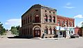
Old building on main street of Aguilar, 1946.
|
|
| Motto(s):
"Gateway to the Spanish Peaks"
|
|

Location of the Town of Aguilar in Las Animas County, Colorado.
|
|
| Country | United States |
| State | Colorado |
| County | Las Animas |
| Founded | 1894 |
| Incorporated (town) | January 10, 1894 |
| Government | |
| • Type | Statutory Town |
| Area | |
| • Total | 0.39 sq mi (1.02 km2) |
| • Land | 0.39 sq mi (1.02 km2) |
| • Water | 0.00 sq mi (0.00 km2) |
| Elevation | 6,388 ft (1,947 m) |
| Population
(2020)
|
|
| • Total | 456 |
| • Density | 1,163.27/sq mi (448.79/km2) |
| Time zone | UTC−07:00 (MST) |
| • Summer (DST) | UTC−06:00 (MDT) |
| ZIP code |
81020
|
| Area code(s) | 719 |
| FIPS code | 08-00760 |
| GNIS ID | 194464 |
Aguilar is a small town in Las Animas County, Colorado, United States. It's known as a "Statutory Town," which means it follows certain rules set by the state. In 2020, about 456 people lived there. A cattle rancher and pioneer named José Ramón Aguilar started the town in 1894.
Contents
History of Aguilar
Early Settlement and Naming
In 1864, a trading post called San Antonio Plaza was set up where Aguilar is today. This post was created by Agapito Ribali. Later, in 1875, the San Antonio post office opened. The settlement was then renamed Schultz Plaza after William Schultz, who built the first store there.
In 1879, J. Ramón Aguilar came to the area. He bought the land in and around the settlement. The Aguilar, Colorado, post office officially opened on December 16, 1890. The town of Aguilar was formally created on January 18, 1894, and was named after him.
Coal Mining and Railways
Coal mining became important to Aguilar. In 1888, the Peerless coal mine opened nearby. A few years later, in 1892, the Union Pacific, Denver and Gulf Railway built a special train track (a spur line) from Acme to Aguilar. This track also went to the Peerless mine.
Later, in 1898, the Colorado and Southern Railway took over this line. They extended the track to Brodhead in 1900. This helped serve other coal mines in the area, like the Empire, Gem, and Green Canyon mines.
The Colorado Coalfield War
From September 1913 to April 1914, there was a big conflict in Las Animas County called the Colorado Coalfield War. This was a time when many coal miners went on strike. Up to 12,000 miners, who were part of the United Mine Workers of America union, were involved. They had both peaceful protests and some fights with the mining companies, especially the Colorado Fuel & Iron Company, which was owned by Rockefeller. They also faced strikebreakers and the Colorado National Guard.
During this time, on October 29, 1913, the Aguilar post office and other buildings were burned down. This was linked to the strike. The National Guard arrested some strikers for the attack.
After a sad event called the Ludlow Massacre on April 20, 1914, the strikers fought back. This period was known as the Ten-Day War. On April 22, some armed strikers attacked the Empire Mine. They forced miners who were still working and their families into the mine. They then surrounded the mine all night. The mayor of Aguilar and a church minister helped to talk things out. The strikers eventually left, and no one was hurt.
Geography
Aguilar is located in Las Animas County. Its exact location is 37°24′10″N 104°39′12″W / 37.4028°N 104.6533°W. It is about one mile west of Interstate 25, a major highway.
In 2020, the town covered an area of about 1.016 square kilometers (0.39 square miles). All of this area is land.
Climate
| Climate data for Aguilar | |||||||||||||
|---|---|---|---|---|---|---|---|---|---|---|---|---|---|
| Month | Jan | Feb | Mar | Apr | May | Jun | Jul | Aug | Sep | Oct | Nov | Dec | Year |
| Mean daily maximum °F (°C) | 38.2 (3.4) |
43.9 (6.6) |
51.7 (10.9) |
60.4 (15.8) |
70 (21) |
81.8 (27.7) |
88.7 (31.5) |
86.8 (30.4) |
78.1 (25.6) |
65.6 (18.7) |
49.2 (9.6) |
40.4 (4.7) |
62.9 (17.2) |
| Mean daily minimum °F (°C) | 11.9 (−11.2) |
17.1 (−8.3) |
23.8 (−4.6) |
31.6 (−0.2) |
41.7 (5.4) |
51 (11) |
56.7 (13.7) |
55 (13) |
45.7 (7.6) |
33.5 (0.8) |
21.7 (−5.7) |
13.7 (−10.2) |
33.6 (0.9) |
| Average precipitation inches (mm) | 0.6 (15) |
0.7 (18) |
1.7 (43) |
2.1 (53) |
2.6 (66) |
1.8 (46) |
2.7 (69) |
3.1 (79) |
1.6 (41) |
1 (25) |
1 (25) |
0.7 (18) |
19.6 (500) |
| Source: Weatherbase | |||||||||||||
Population Data
| Historical population | |||
|---|---|---|---|
| Census | Pop. | %± | |
| 1900 | 698 | — | |
| 1910 | 858 | 22.9% | |
| 1920 | 1,236 | 44.1% | |
| 1930 | 1,383 | 11.9% | |
| 1940 | 1,397 | 1.0% | |
| 1950 | 1,038 | −25.7% | |
| 1960 | 777 | −25.1% | |
| 1970 | 699 | −10.0% | |
| 1980 | 624 | −10.7% | |
| 1990 | 520 | −16.7% | |
| 2000 | 593 | 14.0% | |
| 2010 | 538 | −9.3% | |
| 2020 | 456 | −15.2% | |
| U.S. Decennial Census | |||
The population of Aguilar has changed over the years. In 1900, there were 698 people. The population grew to its highest in 1940 with 1,397 people. Since then, the number of residents has slowly decreased. In 2020, the population was 456.
In 2000, there were 593 people living in Aguilar. The town had about 1,508 people per square mile (or 582 people per square kilometer). About 46.5% of the population identified as Hispanic or Latino.
The average age of people in Aguilar in 2000 was 45 years old. About 23.3% of the population was under 18 years old.
Education
Aguilar Public Schools is the local school district. It is called the Aguilar Reorganized School District RE-6. The district has two schools:
- Aguilar Elementary School
- Aguilar Junior/Senior High School
Both schools are located within the town of Aguilar.
Transportation
Aguilar is part of Colorado's Bustang network. This is a public bus service that connects different towns. Aguilar is on the Trinidad-Pueblo Outrider line, which means you can catch a bus to these other cities from Aguilar.
Images for kids
-
A building in Aguilar today.
.JPG)
See also
 In Spanish: Aguilar (Colorado) para niños
