Ahwatukee, Phoenix facts for kids
Quick facts for kids
Ahwatukee
|
|
|---|---|
|
Urban village
|
|
| Ahwatukee Foothills Village | |
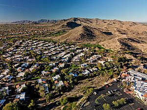
Aerial view of Ahwatukee neighborhoods and South Mountain Park
|
|
| Motto(s):
Warm People, Bright Future
|
|
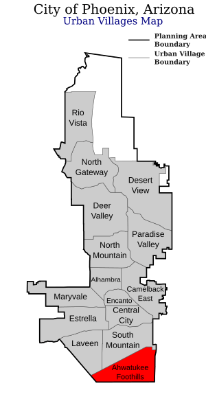
Location of Ahwatukee Foothills highlighted in red.
|
|
| Country | United States |
| State | Arizona |
| County | Maricopa |
| City | Phoenix |
| Area | |
| • Total | 35.8 sq mi (93 km2) |
| Elevation | 1,283 ft (391 m) |
| Population
(2016 Estimate)
|
|
| • Total | 83,464 |
| • Density | 1,783/sq mi (688/km2) |
| GNIS feature ID | 24705 |
| Website | Ahwatukee Foothills Village Planning Committee |
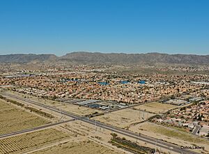
Ahwatukee Foothills, often just called Ahwatukee, is a special part of Phoenix, Arizona. It's the southernmost tip of Phoenix. It's also part of the East Valley, a bigger area around Phoenix. In 2022, a group called Niche said Ahwatukee was the '#1 Best Neighborhood to Live in Phoenix.'
Contents
History of Ahwatukee
Before Ahwatukee became the community it is today, the name "Ahwatukee" sometimes referred to a house. This house was located near Sequoia Trails and Appaloosa Drive. It has since been torn down.
How Ahwatukee Began
Some main roads in Ahwatukee are named after people who claimed land here. This happened after the Homestead Acts were signed in 1862. Warner Road is named after Samuel Warner from Kansas. Elliot Road is named after Reginald Elliott from California. Both claimed land in an area now called Tempe.
Another person, Arthur Hunter, claimed land where Ahwatukee is now. For a while, 48th Street was called Hunter Drive after him. There's a rumor that in the 1940s, Arthur Hunter buried a Studebaker car in the Ahwatukee desert. People say it belonged to Al Capone.
The Ahwatukee Ranch House
One of the first houses in the area was built by Dr. William Van Bergen Ames. He helped start Northwestern University's Dental School. The house was built on more than 2,000 acres of land. This land was bought for $4 an acre.
The Chandler Arizonan newspaper called the house "unmatched in scope and size." It was in the foothills of the South Mountain. The house was a 12,000 square foot winter home. It was designed by a famous Phoenix architect, Lester Mahoney. Building started in 1921.
The newspaper called it "The Mystic House" because it was so big and expensive. It was also in a very quiet, isolated spot. The Ames family called it Casa de Sueños, which means "House of Dreams." They moved in on Thanksgiving in 1921. Sadly, Dr. Ames died in February 1922. His wife kept spending winters there until she passed away in 1933.
After Mrs. Ames died, the property went to St. Luke's Hospital. Helen Brinton bought the property in 1935. She gave the house, and later the whole area, the name "Ahwatukee." Helen Brinton died in 1960. The original house was torn down in 1979.
International Harvester's Proving Grounds
In 1946, the International Harvester Company rented land. This land was west of today's Lakewood community. It was used for testing trucks and heavy equipment. This testing area grew to more than 4,000 acres.
The testing grounds had a 7.5-mile test track. It also had dirt tracks and a special area with steep hills. There were also repair shops and a runway for company leaders. The company sold the grounds in 1983. This was due to money problems and other issues. This area is now part of The Foothills and Club West neighborhoods.
How Ahwatukee Was Developed
Ahwatukee started to be developed in 1970. Presley Development Company bought 2,080 acres of land. This land included the old Ahwatukee Ranch. At first, the company planned for it to be a retirement community. Later, they decided to mix retirement homes with family homes and small businesses.
Presley Development helped Ahwatukee become part of Phoenix. It didn't join nearby Chandler or Tempe. This happened through an agreement between a county leader and the Mayor of Phoenix. Chandler and Tempe had actually said no to adding Ahwatukee.
Phoenix slowly added Ahwatukee in parts from 1980 to 1987. Some people think this affected how Tempe grew later on. Plans for Ahwatukee were approved in November 1971. Seventeen model homes opened in 1973 near 50th Street and Elliot Road.
In the same year, the Arizona State Legislature planned to build a prison nearby. However, these plans were later canceled. Ahwatukee's first elementary school, Kyrene de los Lomas, opened in 1976. Mountain Pointe High School opened in 1991 as the area's first high school.
What Does "Ahwatukee" Mean?
There are three main ideas about where the name "Ahwatukee" came from. All three ideas say the name comes from the Crow language.
Some stories say Helen Brinton chose a Crow name for her property. She had spent time with the Crow Nation in Wyoming. This experience influenced her choice.
"House of Dreams"
Some people say the name means house of your dreams or house of dreams in Crow. The Ahwatukee Foothills Chamber of Commerce used to say it meant house of dreams.
However, the Crow language dictionary says the Crow word for "house" is ashé. The word for "dream" is baashíale or balewaashíale.
"Land on the Other Side of the Hill"
Other sources say the name means land on the other side of the hill. This is based on the Crow words awe chuuke. The Crow dictionary says awé means "ground" or "land." And chúuke means "over the ridge" or "over the hill."
"Flat Land"
One idea is that the name sounds like a Crow term for "flat land" or "prairie." The Crow word for "flat land" is "alawachúhke."
Geography of Ahwatukee
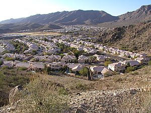
The Ahwatukee Foothills Village has clear borders. Interstate 10 is to the east. South Mountain is to the north. The Gila River Indian Community and Loop 202 are to the west and south. Ahwatukee is somewhat separated from the rest of Phoenix. It was once thought to be a good place for a more rural, spread-out type of development.
People of Ahwatukee
In 2016, about 83,464 people lived in Ahwatukee Foothills Village. Most of the people (83%) were White. About 6.5% were Asian. Around 5.6% were Black or African American. About 1.6% were Native American. And 3.3% identified as another race. Also, 12.3% of the people were Hispanic.
Education in Ahwatukee
Public Schools
Students in kindergarten through 8th grade go to schools run by the Kyrene School District. Many of Kyrene's schools (12 out of 25) are located in Ahwatukee.
High school students attend one of two schools in the area. These are Desert Vista and Mountain Pointe. Both high schools are part of the Tempe Union High School District.
Private Schools
Ahwatukee also has several private schools. One of them, Summit School of Ahwatukee, was named one of the most expensive private schools in Phoenix in 2014.
Transportation in Ahwatukee
The community has a local bus service called ALEX. It is run by Valley Metro Bus. However, some riders have said the service has not been as good since 2016. Other Valley Metro bus routes also serve parts of Ahwatukee.
Ahwatukee used to have only a few ways to get in and out. This was mainly through 48th Street and some crossings over I-10. Because of this, Ahwatukee was sometimes called the world's largest cul-de-sac. But the building of Loop 202's South Mountain Freeway changed this. It gave the area a new way to enter and exit from the west.
See Also
- List of Phoenix, Arizona points of interest
 | Lonnie Johnson |
 | Granville Woods |
 | Lewis Howard Latimer |
 | James West |


