Air Force Island facts for kids

Air Force Island, Nunavut
|
|
| Geography | |
|---|---|
| Location | Foxe Basin |
| Coordinates | 67°58′N 74°05′W / 67.967°N 74.083°W |
| Archipelago | Canadian Arctic Archipelago |
| Area | 1,720 km2 (660 sq mi) |
| Administration | |
| Territory | Nunavut |
| Region | Qikiqtaaluk |
| Demographics | |
| Population | Uninhabited |
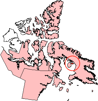
Air Force Island is a large island located in the Qikiqtaaluk Region of Nunavut, Canada. It is an uninhabited island, meaning no people live there permanently. The island is found along the southwestern coast of Baffin Island, which is Canada's largest island. Air Force Island is quite big, measuring about 1,720 square kilometers (664 square miles) in size.
Discovering Air Force Island
The first time Air Force Island was officially recorded was in 1948. This discovery was made by a crew member of the Royal Canadian Air Force (RCAF). His name was Albert-Ernest Tomkinson. He was navigating an Avro Lancaster aircraft when he spotted the island.
Why the Name "Air Force Island"?
The island was given its name to honor the important work of the Royal Canadian Air Force. The RCAF played a big role in exploring and mapping the many islands of the Canadian Arctic Archipelago. This archipelago is a huge group of islands in the far north of Canada. Naming the island "Air Force Island" was a way to recognize their efforts in surveying this remote and icy region.
At the same time, two other nearby islands were also recorded: Prince Charles Island and Foley Island. These discoveries helped to complete the maps of Canada's vast Arctic territories.
See also
 In Spanish: Isla Air Force para niños
 | Ernest Everett Just |
 | Mary Jackson |
 | Emmett Chappelle |
 | Marie Maynard Daly |


