Foley Island facts for kids

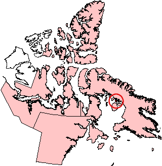
Foley Island, Nunavut.
|
|
| Geography | |
|---|---|
| Location | Foxe Basin |
| Coordinates | 68°30′N 75°00′W / 68.500°N 75.000°W |
| Archipelago | Canadian Arctic Archipelago |
| Area | 637 km2 (246 sq mi) |
| Administration | |
| Nunavut | Nunavut |
| Region | Qikiqtaaluk |
| Demographics | |
| Population | Uninhabited |
Foley Island is a large island located in the Canadian Arctic. It is part of Nunavut, Canada. You can find it along the southern coast of Baffin Island in a large body of water called the Foxe Basin. Foley Island is about 637 square kilometers (246 square miles) in size. No one lives on Foley Island.
Discovering Foley Island
Foley Island was not known to the world until 1948. It was first recorded by a member of the Royal Canadian Air Force. This person was Albert-Ernest Tomkinson, who was navigating an Avro Lancaster airplane.
Tomkinson and his crew were flying over the area when they discovered Foley Island. They also found two other nearby islands at the same time: Prince Charles Island and Air Force Island. This discovery helped to map out more of Canada's vast Arctic region.
See also
 In Spanish: Isla Foley para niños
 | May Edward Chinn |
 | Rebecca Cole |
 | Alexa Canady |
 | Dorothy Lavinia Brown |


