Airlie Beach, Queensland facts for kids
Quick facts for kids Airlie BeachQueensland |
|||||||||||||||
|---|---|---|---|---|---|---|---|---|---|---|---|---|---|---|---|

Airlie Beach
|
|||||||||||||||
| Population | 1,312 (2021 census) | ||||||||||||||
| Postcode(s) | 4802 | ||||||||||||||
| Location |
|
||||||||||||||
| LGA(s) | Whitsunday Region | ||||||||||||||
| State electorate(s) | Whitsunday | ||||||||||||||
| Federal Division(s) | Dawson | ||||||||||||||
|
|||||||||||||||
Airlie Beach is a beautiful coastal town in Queensland, Australia. It's known as a popular holiday spot and a gateway to the amazing Whitsunday Islands and the Great Barrier Reef. In 2021, about 1,312 people lived in Airlie Beach.
Contents
Discovering Airlie Beach's Location
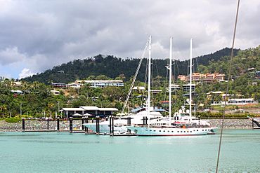
Airlie Beach is perfectly located for exploring the Great Barrier Reef. Many boats leave from here to take visitors to this incredible natural wonder. Large cruise ships also visit, bringing passengers ashore by smaller boats to the local marinas.
This area, including nearby Proserpine and the Whitsunday Islands, has a warm, tropical climate. This means it's sunny and warm for most of the year! The main road, Proserpine–Shute Harbour Road, runs right through the town.
A Glimpse into Airlie Beach's Past
How Airlie Beach Got Its Name
The name "Airlie" comes from a place in Scotland. In 1935, the local council needed a name for a new area on the coast. Robert Shepherd, who was born in Scotland, suggested "Airlie" after his home country.
From 1936 to 1987, the official town name was just Airlie. Later, it became part of a larger town called Whitsunday, and the coastal area became officially known as Airlie Beach. The Airlie Beach Post Office opened in 1959.
Busking and Community Life
In 2010, the local council made busking legal. This means musicians and performers can entertain people on the streets, adding to the town's lively atmosphere.
Airlie Beach is a hub for tourism. Many people who live here work in hotels, restaurants, and tour companies. Like many places, it faced challenges during the 2020 global health situation, which affected travel and tourism.
Who Lives in Airlie Beach?
In 2016, about 1,208 people lived in Airlie Beach. Most residents (50.9%) were born in Australia. The next largest group came from England (9.2%). English was the main language spoken at home by 71.2% of people. Many people (34.7%) said they had no religion. By 2021, the population had grown slightly to 1,312 people.
Learning and Schools
Airlie Beach itself doesn't have any schools. Students usually go to school in nearby towns. The closest primary school is Cannonvale State School in Cannonvale. For high school, students attend Proserpine State High School in Proserpine.
Important Places and Services
Airlie Beach has important facilities for boats and safety:
- Marinas: There are two main marinas where boats can dock:
* Abel Point Marina (20°15′58″S 148°42′36″E / 20.2660°S 148.7100°E) * Port of Airlie Marina (20°16′13″S 148°43′30″E / 20.2703°S 148.7250°E)
- Boat Ramps: Two boat ramps are available for launching boats:
* One at Abel Point off Shingley Drive (20°15′58″S 148°42′44″E / 20.2662°S 148.7123°E) * Another at Port of Airlie (20°16′25″S 148°43′32″E / 20.2736°S 148.7256°E)
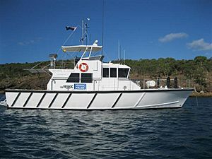
- Water Police: The Airlie Beach Water Police Station is located at 38 Shingley Drive (20°15′58″S 148°42′47″E / 20.2661°S 148.7130°E). They are responsible for keeping the waters safe from Cape Upstart in the north to St Lawrence in the south.
Fun Events in Airlie Beach
Great Barrier Reef Festival
Every year, Airlie Beach hosts The Great Barrier Reef Festival. This exciting event includes fireworks over the water and live music from local artists. It's a celebration of the amazing reef and the community.
Airlie Beach Festival of Music
In November, the Airlie Beach Festival of Music takes place over several days. This festival brings together both Australian and international musicians who perform at different venues around the area. It's a great time for music lovers!
 | Calvin Brent |
 | Walter T. Bailey |
 | Martha Cassell Thompson |
 | Alberta Jeannette Cassell |


