Proserpine, Queensland facts for kids
Quick facts for kids ProserpineQueensland |
|||||||||||||||
|---|---|---|---|---|---|---|---|---|---|---|---|---|---|---|---|

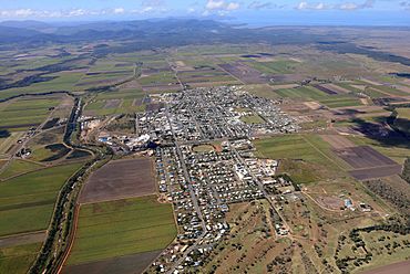
Aerial image of Proserpine
|
|||||||||||||||
| Population | 3,614 (2021 census) | ||||||||||||||
| • Density | 154.4/km2 (400/sq mi) | ||||||||||||||
| Established | 1890s | ||||||||||||||
| Postcode(s) | 4800 | ||||||||||||||
| Elevation | 20 m (66 ft) | ||||||||||||||
| Area | 23.4 km2 (9.0 sq mi) | ||||||||||||||
| Time zone | AEST (UTC+10:00) | ||||||||||||||
| Location |
|
||||||||||||||
| LGA(s) | Whitsunday Region | ||||||||||||||
| State electorate(s) | Whitsunday | ||||||||||||||
| Federal Division(s) | Dawson | ||||||||||||||
|
|||||||||||||||
|
|||||||||||||||
Proserpine is a town in the Whitsunday Region of Queensland, Australia. It is a rural area, meaning it is mostly countryside with farms. In 2021, about 3,614 people lived in Proserpine.
Contents
Where is Proserpine?
Proserpine is located on the Bruce Highway, a major road in Queensland. You can also reach the town by train, as it is on the North Coast line. The Proserpine railway station is right in the town centre.
The town sits along the Proserpine River. The land around it is mostly flat and used for growing sugarcane and raising cattle. To the west, you'll find the Clarke Range mountains. Dryander National Park is to the north, and Conway National Park is to the east.
The local government for Proserpine is the Whitsunday Regional Council. This council looks after the area, including towns like Bowen.
A Look Back at Proserpine's History
Traditional Owners of the Land
The Gia people are the original custodians of the land around Proserpine. Their language, Giya (also known as Kia), is spoken in this part of North Queensland. This includes the areas of Bowen and Proserpine.
How Proserpine Got Its Name
In 1859, George Elphinstone Dalrymple explored this area and named the Proserpine River. He called it Proserpine after the Greek goddess Persephone. In Roman myths, her name is Proserpine. She is the goddess of spring and new growth. Dalrymple thought the area was very fertile, like a place blessed by a goddess of spring.
Early European Settlements
The first European settlers arrived in the early 1860s. Daniel Emmerson started a large farm called a pastoral station here. Other settlers, like Frederick Bode and William Dangar, also set up farms nearby.
The Start of the Sugar Industry
In 1882, the Crystal Brook Sugar Company began growing sugar in the region. They built a sugar mill a year later. At first, workers from the South Sea Islands helped on the sugar plantations. By 1893, the big plantation closed. Smaller sugar farms, run by individual owners, then took over.
Schools in Proserpine
Proserpine Lower Provisional School was the first school, opening in 1897. It later became Proserpine State School. In 1937, it started offering secondary classes for older students.
St Catherine's Catholic School opened in 1925. It was a primary school run by the Sisters of Mercy. In 2012, the school moved to a new, bigger campus. It then became St Catherine's Catholic College, offering both primary and secondary education.
Proserpine State High School opened its doors in 1963. It took over the secondary education from Proserpine State School.
Modern Developments
Proserpine Airport (now called Whitsunday Coast Airport) started operating in 1951. This made it easier for people to travel to and from the area.
In 1986, work began on the Peter Faust Dam, about 25 kilometers (15 miles) northwest of town. This dam helps control floods during the wet season and provides water for farming. It was finished in 1990.
In March 2017, Proserpine was hit by Cyclone Debbie, which caused a lot of damage to the town.
Proserpine's Economy
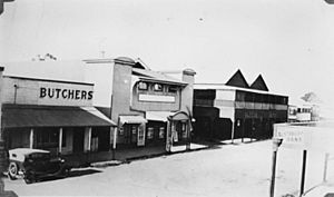
One of the most important industries in Proserpine is sugar production. The Proserpine Sugar Mill was built in 1897. Today, it is known as one of the most modern sugar mills in the world. This means it uses advanced technology to process sugarcane.
Education in Proserpine
Proserpine has several schools for students of all ages:
- Proserpine State School is a government primary school for children from early childhood up to Year 6. It also has a special education program.
- St Catherine's Catholic College is a Catholic school that teaches students from Kindergarten all the way to Year 12.
- Proserpine State High School is a government secondary school for students from Year 7 to Year 12. It also offers a special education program.
Important Places in Proserpine
Health Services
The Proserpine Hospital on Taylor Street is the main hospital for the entire Whitsunday Region. It provides important health care services to the community.
Community Hubs
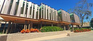
The Proserpine Entertainment Centre is a place where people can go for shows and events. It is located on Main Street. The centre was rebuilt and reopened in 2022 after being damaged by Cyclone Debbie in 2017.
The Proserpine Library opened in 1998. It's a great place to find books, learn, and connect with the community.
Weather in Proserpine
Proserpine has a warm climate with a dry winter. This type of weather is called a humid subtropical climate. It's similar to the weather in nearby Mackay.
| Climate data for Proserpine Airport | |||||||||||||
|---|---|---|---|---|---|---|---|---|---|---|---|---|---|
| Month | Jan | Feb | Mar | Apr | May | Jun | Jul | Aug | Sep | Oct | Nov | Dec | Year |
| Record high °C (°F) | 41.2 (106.2) |
40.4 (104.7) |
37.9 (100.2) |
34.0 (93.2) |
32.0 (89.6) |
32.0 (89.6) |
32.7 (90.9) |
34.1 (93.4) |
36.3 (97.3) |
39.0 (102.2) |
41.2 (106.2) |
42.9 (109.2) |
42.9 (109.2) |
| Mean daily maximum °C (°F) | 31.4 (88.5) |
31.1 (88.0) |
30.2 (86.4) |
28.7 (83.7) |
26.5 (79.7) |
24.5 (76.1) |
24.3 (75.7) |
25.6 (78.1) |
28.4 (83.1) |
30.2 (86.4) |
31.4 (88.5) |
32.0 (89.6) |
28.7 (83.7) |
| Mean daily minimum °C (°F) | 22.6 (72.7) |
22.9 (73.2) |
21.5 (70.7) |
19.1 (66.4) |
15.8 (60.4) |
12.7 (54.9) |
11.0 (51.8) |
11.7 (53.1) |
14.4 (57.9) |
17.5 (63.5) |
19.9 (67.8) |
21.8 (71.2) |
17.6 (63.7) |
| Record low °C (°F) | 15.9 (60.6) |
15.0 (59.0) |
14.2 (57.6) |
7.6 (45.7) |
5.0 (41.0) |
0.5 (32.9) |
−0.9 (30.4) |
0.0 (32.0) |
3.8 (38.8) |
7.4 (45.3) |
13.0 (55.4) |
14.3 (57.7) |
−0.9 (30.4) |
| Average precipitation mm (inches) | 290.1 (11.42) |
381.9 (15.04) |
209.0 (8.23) |
118.3 (4.66) |
70.4 (2.77) |
38.1 (1.50) |
23.7 (0.93) |
25.9 (1.02) |
18.9 (0.74) |
36.2 (1.43) |
88.7 (3.49) |
165.8 (6.53) |
1,473.5 (58.01) |
Famous People from Proserpine
Many talented people have come from Proserpine, including:
- Paul Bowman: A professional rugby league player who played for the North Queensland Cowboys.
- Alan Dufty: A former professional wheelchair racer.
- Sam Faust: A professional rugby league player.
- Andrew Fraser: A Queensland State Politician.
- Max Grosskreutz: An Australian speedway rider.
- Billy Sing: A famous Australian sniper during World War I.
- Travis Waddell: A professional rugby league footballer who played for the Newcastle Knights.
 | Sharif Bey |
 | Hale Woodruff |
 | Richmond Barthé |
 | Purvis Young |


