Whitsunday Region facts for kids
Quick facts for kids Whitsunday RegionQueensland |
|||||||||||||||
|---|---|---|---|---|---|---|---|---|---|---|---|---|---|---|---|

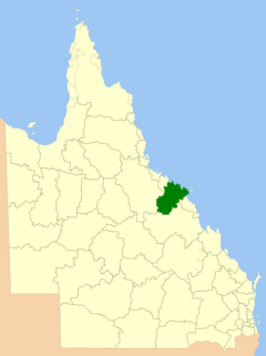
Location within Queensland
|
|||||||||||||||

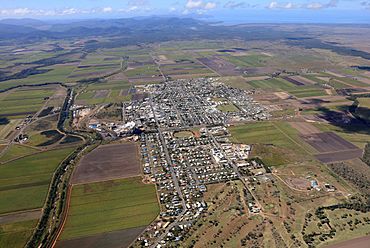
Aerial view of Proserpine, the service & administrative centre and ultimately gateway to the region by road, rail and air
|
|||||||||||||||
| Population | 37,152 (2021 census) | ||||||||||||||
| • Density | 1.55976/km2 (4.0398/sq mi) | ||||||||||||||
| Established | 2008 | ||||||||||||||
| Area | 23,819 km2 (9,196.6 sq mi) | ||||||||||||||
| Mayor | Ry Collins | ||||||||||||||
| Council seat | Proserpine | ||||||||||||||
| Region | North Queensland | ||||||||||||||
| State electorate(s) |
|
||||||||||||||
| Federal Division(s) | |||||||||||||||
 |
|||||||||||||||
| Website | Whitsunday Region | ||||||||||||||
|
|||||||||||||||
The Whitsunday Region is a special area in North Queensland, Australia. It has its own local government. This means it has a council that makes decisions for the people living there. The region was created in 2008. Before that, it was made up of two smaller local government areas.
In 2021, about 37,152 people lived in the Whitsunday Region.
Contents
- What is the History of the Whitsunday Region?
- How is the Whitsunday Council Organized?
- What Towns and Localities are in the Whitsunday Region?
- Where are the Public Libraries in the Whitsunday Region?
- How Has the Population of the Whitsunday Region Changed?
- Who are the Mayors of the Whitsunday Region?
What is the History of the Whitsunday Region?
Before 2008, the Whitsunday Region was split into two separate areas. These were the Shire of Bowen and the Shire of Whitsunday.
Over time, these areas changed. For example, the town of Bowen became part of the Shire of Wangaratta in 1960. Later, the Shire of Wangaratta was renamed Bowen.
In 2007, the government suggested joining these two areas. Both local councils and the people living there did not want this to happen. However, if they had to choose, they preferred to join with each other. So, on March 15, 2008, the two shires officially became one. People then voted for new leaders for the combined region.
In 2012, some people wanted to split the region back into two. They signed a petition, but the government said no. They explained that splitting up would not be good for the region's money.
How Did Cyclone Debbie Affect the Whitsunday Region?
In March 2017, a very strong storm called Cyclone Debbie hit the Whitsunday Region. Many parts of the area were damaged. The main council building in Proserpine was badly hurt.
After the cyclone, a new council building was planned for Proserpine. This new building will also be a special center. It will help the region prepare for and recover from future disasters.
How is the Whitsunday Council Organized?
The Whitsunday Regional Council is divided into six parts, called divisions. Each division chooses one person to be a councillor. There is also a mayor who leads the whole council.
What Towns and Localities are in the Whitsunday Region?
The Whitsunday Region includes many towns and smaller areas. Some of the main ones are:
Where are the Public Libraries in the Whitsunday Region?
The Whitsunday Regional Council runs public libraries in several towns. You can find libraries in:
How Has the Population of the Whitsunday Region Changed?
The number of people living in the Whitsunday Region has grown over the years. Here's a quick look at the total population:
| Year | Population (Total) |
|---|---|
| 1933 | 11,477 |
| 1961 | 14,604 |
| 1991 | 29,388 |
| 2001 | 32,021 |
| 2011 | 31,426 |
| 2021 | 37,152 |
Who are the Mayors of the Whitsunday Region?
The mayor is the main leader of the Whitsunday Regional Council. Here are the people who have been mayor since the region was formed in 2008:
| # | Name | Years in office |
|---|---|---|
| 1 | Mike Brunker | 2008–2012 |
| 2 | Jennifer Whitney | 2012–2016 |
| 3 | Andrew Willcox | 2016–2022 |
| 4 | Julie Hall | 2022–present |
 | George Robert Carruthers |
 | Patricia Bath |
 | Jan Ernst Matzeliger |
 | Alexander Miles |


