Airmont, New York facts for kids
Quick facts for kids
Airmont, New York
|
|
|---|---|

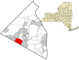
Location in Rockland County and the state of New York.
|
|
| Country | United States |
| State | New York |
| County | Rockland |
| Incorporated | 1991 |
| Area | |
| • Total | 4.57 sq mi (11.83 km2) |
| • Land | 4.57 sq mi (11.82 km2) |
| • Water | 0.00 sq mi (0.00 km2) |
| Elevation | 584 ft (178 m) |
| Population
(2020)
|
|
| • Total | 10,166 |
| • Density | 2,226.94/sq mi (859.80/km2) |
| Time zone | UTC-5 (EST) |
| • Summer (DST) | UTC-4 (EDT) |
| ZIP code |
10952, 10901
|
| Area code(s) | 845 329 |
| FIPS code | 36-00408 |
| GNIS feature ID | 2391502 |
Airmont is a village in Rockland County, New York, United States. It is located north of New Jersey. To its east is Chestnut Ridge, and to its west is Suffern.
Airmont became an official village in 1991. It was formed by combining the smaller areas of Tallman, Airmont, and South Monsey. People who helped create the village wanted to keep its quiet, suburban feel.
Contents
History of Airmont
When Airmont became a village in 1991, it had about 9,500 residents. The village leaders wanted to use "strong zoning" rules. These rules help decide how land can be used and what types of buildings can be built.
Over the years, Airmont has faced some legal challenges. These challenges were often about its zoning laws. For example, in 1991, a lawsuit was filed. It claimed that Airmont's zoning plan might make it hard for some religious groups to live there. This was because the plan restricted where religious buildings, like synagogues, could be built. The lawsuit said this went against laws like the Fair Housing Act.
As a result, Airmont had to change its zoning rules. This allowed religious sites to be built more easily. Even with these changes, legal discussions about zoning continued for several years.
Around 2005, a religious group wanted to build a school and housing for students. Some residents were against this plan. This led to more legal discussions and lawsuits. In 2011, Airmont and the U.S. government reached an agreement. Airmont agreed to change its zoning code again. This would allow the school and student housing to be built.
In 2020, the Department of Justice filed another lawsuit. They said Airmont's land use policies were still causing religious discrimination. This was against earlier court decisions and federal law.
In 2021, a village official was arrested on weapons charges. He later pleaded guilty to a serious crime. This meant he had to leave his position as deputy mayor.
By October 2023, the Department of Justice settled its discrimination lawsuit with the village. This settlement was about the zoning of places of worship.
Geography of Airmont
Airmont is located at coordinates 41°5′57″N 74°6′0″W / 41.09917°N 74.10000°W.
The village covers a total area of about 12 square kilometers (4.57 square miles). All of this area is land.
The southern edge of Airmont is right on the border of New Jersey.
Population Information
Airmont has grown over the years.
| Historical population | |||
|---|---|---|---|
| Census | Pop. | %± | |
| 2000 | 7,799 | — | |
| 2010 | 8,628 | 10.6% | |
| 2020 | 10,166 | 17.8% | |
| 2021 (est.) | 10,114 | 17.2% | |
| U.S. Decennial Census | |||
Airmont in 2020
In 2020, the village had 10,166 people living there. There were 2,571 households. This means there were about 2,227 people per square mile.
Most of the population, about 81.2%, identified as White. About 4.9% were African American, and 2.5% were Asian. People of Hispanic or Latino origin made up 15.2% of the population.
About 33.5% of the people were under 18 years old. About 6.6% were under 5 years old. People over 65 years old made up 14.9% of the population. The village had slightly more females (52%) than males (48%).
The average household income was $98,750. The average income per person was $34,051. About 10.9% of the population lived below the poverty line.
Things to See and Do
Historical Markers
- Christ Evangelical Lutheran Church - You can find this church at the corner of Church and Airmont roads.
- Dogwoods - This marker is located at 24 DeBaun Avenue.
Landmarks and Interesting Places
- Christ Evangelical Lutheran Church was first started in 1715. The current church building was built in 1855.
- Challenger Center for Space Science Education is a place where you can learn about space science.
- Spook Rock is a large rock formation near Airmont. It's located on Spook Rock Road and Highview Avenue. Long ago, Native American tribes in the area, like the Tappan and Warawankogs, believed in a spirit called Manitou.
Education in Airmont
Most students in Airmont attend schools in the Suffern Central School District.
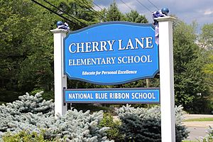
- Cherry Lane Elementary School is one of the local elementary schools. It won a special award, the National Blue Ribbon School award, in 2013.
- Students also go to Suffern Middle School and Suffern High School.
Some parts of Airmont are in the East Ramapo Central School District.
There is also a religious school called Central United Talmudical Academy of Monsey in Airmont.
For higher education, Rockland Community College is located nearby. It is part of the SUNY system.
Notable Person
- Lipa Schmeltzer (born 1978) is a famous American Hasidic singer and composer.
See also
 In Spanish: Airmont (Nueva York) para niños
 | Janet Taylor Pickett |
 | Synthia Saint James |
 | Howardena Pindell |
 | Faith Ringgold |


