
Alamo Hueco Mountains facts for kids
Quick facts for kids Alamo Hueco Mountains |
|
|---|---|

Map of ranges in New Mexico Bootheel region,
showing Animas, Playas, and Hachita Valleys (Chiricahua Mountains of Arizona, at west) |
|
| Highest point | |
| Peak | Pierce Peak (New Mexico) (Alamo Hueco Mountains) |
| Elevation | 6,159 ft (1,877 m) |
| Dimensions | |
| Length | 15 mi (24 km) NW-SE |
| Width | 8 mi (13 km) |
| Geography | |

Alamo Hueco Mountains
Location in New Mexico
|
|
| Country | United States |
| State | New Mexico |
| Regions | New Mexico Bootheel ((northwest)-Chihuahuan Desert) Continental Divide of the Americas |
| County | Hidalgo County, NM |
| Communities | Alamo Hueco, NM–Pierce, NM (McFarlands, New Mexico) |
| Borders on | Playas Valley-NW, W & SW Big Hatchet Mountains-N Chihuahuan Desert–Chihuahua, Mexico-E Dog Mountains-S |
The Alamo Hueco Mountains are a mountain range in New Mexico, United States. They are about 15 miles (24 km) long. You can find them in the southeast part of the New Mexico Bootheel region. This area is in Hidalgo County. The mountains are very close to the border with Chihuahua state in Mexico.
These mountains are part of a longer chain of mountains. This chain runs along the Playas Valley. The Little Hatchet and Big Hatchet Mountains are nearby to the north. The mountain chain eventually ends in the flat Chihuahuan Desert. The smaller Dog Mountains are just to the south.
The famous Continental Divide of the Americas passes near these mountains. The Continental Divide National Scenic Trail actually goes right through them. This trail continues south into the Chihuahuan Desert in Mexico.
Contents
What are the Alamo Hueco Mountains like?
The Alamo Hueco Mountains are about 15 miles (24 km) long. They are also about 8 miles (13 km) wide. The mountains stretch from the northwest to the southeast. They meet the Dog Mountains to the south. This southern end is right on the Mexico–United States Border.
Since the Alamo Hueco Mountains are in the southeast corner of New Mexico's 'Bootheel', the border with Chihuahua, Mexico, is also to their east.
Highest Points in the Range
The tallest point in these mountains is Pierce Peak (New Mexico). It stands at 6,159 feet (1,877 meters) high. This peak is located near the center-northeast part of the range.
Another important peak is Hat Top Mountain. It is 5,168 feet (1,575 meters) tall. Hat Top Mountain is found on the far southeast side of the range. It is a bit separate from the main line of mountains.
What is the Continental Divide National Scenic Trail?
The Continental Divide is like a giant line across North America. It separates the land where water flows to the Pacific Ocean from where it flows to the Atlantic Ocean. This divide is located north of the Big Hatchet Mountains. It crosses the northern part of the Playas Valley.
The Continental Divide National Scenic Trail is a long hiking trail. It follows the Continental Divide. This trail passes through the Big Hatchet Mountains in a couple of different paths. There are also smaller trails that branch off to the southeast. The main part of the Scenic Trail leaves the southwest area of the Big Hatchet Mountains. It then connects with the northwest end of the Alamo Hueco Mountains. From there, it continues its journey south.
-
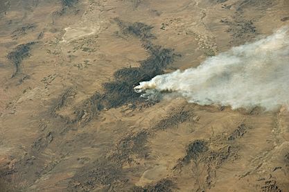
(at photo, bottom-right)
Animas and Playas Valleys, with Alamo Hueco Mountains, and south section of Big Hatchet Mountains

See also
 In Spanish: Sierra del Álamo Hueco para niños
