
Alapocas Run facts for kids
Quick facts for kids Alapocas Run |
|
|---|---|


Location of Alapocas Run mouth
|
|
| Other name(s) | Tributary to Brandywine Creek |
| Country | United States |
| State | Delaware |
| County | New Castle |
| City | Wilmington, Delaware |
| Physical characteristics | |
| Main source | divide between Brandywine Creek and Shellpot Creek Blue Ball, Delaware 320 ft (98 m) 39°46′50″N 075°32′48″W / 39.78056°N 75.54667°W |
| River mouth | Brandywine Creek Wilmington, Delaware 40 ft (12 m) 39°46′07″N 075°33′32″W / 39.76861°N 75.55889°W |
| Length | 1.05 mi (1.69 km) |
| Basin features | |
| Progression | southwest |
| River system | Christina River |
| Basin size | 0.85 square miles (2.2 km2) |
| Tributaries |
|
Alapocas Run is a small stream, like a mini-river, that flows for about 1.05 miles (1.69 kilometers) in Delaware, United States. It's a "tributary," which means it flows into a larger body of water. For Alapocas Run, that larger body is Brandywine Creek. This stream is an important part of Alapocas Run State Park in the Wilmington, Delaware area.
About Alapocas Run
Alapocas Run is a short but important stream. It helps drain water from a big part of Alapocas Run State Park. This park is a popular place for people to visit and enjoy nature. The stream adds to the beauty and environment of the park.
Where Alapocas Run Flows
Alapocas Run starts in an area called Blue Ball, Delaware. This is where the land divides between two other creeks: Brandywine Creek and Shellpot Creek. From there, Alapocas Run flows generally towards the southwest.
The stream ends when it joins Brandywine Creek. This meeting point is located in the city of Wilmington, Delaware. Brandywine Creek is part of a larger system called the Christina River system. This means Alapocas Run's water eventually reaches the Christina River.
Size and Surroundings
Alapocas Run is about 1.05 miles (1.69 kilometers) long. It starts at an elevation of about 320 feet (98 meters) above sea level. By the time it reaches Brandywine Creek, its elevation is about 40 feet (12 meters).
The area that Alapocas Run drains, called its basin, is about 0.85 square miles (2.2 square kilometers). This basin includes much of the state park. The stream also has smaller, unnamed streams that flow into it. These are called tributaries.
Images for kids
-
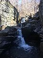
Alapocas Falls in Alapocas Run State Park
.jpg)
