Caledonia Township, Kent County, Michigan facts for kids
Quick facts for kids
Caledonia Township, Michigan
|
|
|---|---|
|
Charter township
|
|
| Charter Township of Caledonia | |

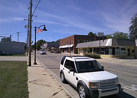
The village of Caledonia within the township
|
|

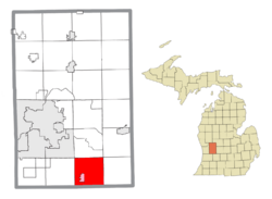
Location within Kent County (red) and the administered village of Caledonia (pink)
|
|
| Country | United States |
| State | Michigan |
| County | Kent |
| Established | 1838 |
| Area | |
| • Total | 35.70 sq mi (92.46 km2) |
| • Land | 34.91 sq mi (90.42 km2) |
| • Water | 0.79 sq mi (2.05 km2) |
| Elevation | 719 ft (219 m) |
| Population
(2020)
|
|
| • Total | 15,811 |
| • Density | 442.89/sq mi (171.004/km2) |
| Time zone | UTC-5 (Eastern (EST)) |
| • Summer (DST) | UTC-4 (EDT) |
| ZIP code(s) | |
| Area code(s) | 616 |
| FIPS code | 26-081-12500 |
| GNIS feature ID | 1626020 |
Caledonia Charter Township is a special kind of town (called a charter township) located in Kent County, Michigan. It's part of the Grand Rapids metropolitan area, which means it's close to the bigger city of Grand Rapids.
In 2020, about 15,811 people lived here. This was a big jump from 12,332 people in 2010! The township was officially set up in 1838.
Contents
Communities in Caledonia Township
Caledonia Township is home to a few different communities. Each has its own story and history.
What is Alaska?
- Alaska is a small, unincorporated community within the township. It's located along the Thornapple River.
- This community started in 1848 with a sawmill built by William H. Brown and Rev. Eber Moffit.
- It first had a post office named "Brownsville" in 1855. But the name quickly changed to "North Brownsville" to avoid confusion with another town.
- In 1868, it was renamed "Alaska." This was likely inspired by the United States buying Alaska from Russia the year before. The post office closed in 1906.
Caledonia Village
- The village of Caledonia is also located within the township. You can find it on M-37 in the southeastern part of the township.
Caledonia Station's History
- Caledonia Station was a settlement that grew around a train station. This station belonged to the Grand River Valley Railroad and was built in 1870. The area was officially mapped out that same year.
Geography and Rivers
Caledonia Township covers about 35.70 square miles (92.46 square kilometers). Most of this area is land, with a small part being water.
Rivers Flowing Through
- The Thornapple River flows north right through the middle of the township.
- The Coldwater River enters the township from the southeast. It flows east and eventually joins up with the Thornapple River.
Major Roads in the Area
- M-6 is a major highway that runs through the northwest part of the township. It connects with M-37.
- M-37 (also known as Broadmoor Avenue and Cherry Valley Avenue) runs from south to north through the eastern side of the township.
Education for Students
All the students in Caledonia Township go to schools run by Caledonia Community Schools. This school district also serves parts of other nearby townships and a small piece of Kentwood city.
How Caledonia Township Was Formed
Caledonia Township was created in 1840. It was formed from parts of Vergennes Township and Ada Township. Later, in 1849, Bowne Township was formed from a part of Caledonia Township.
Who Lives Here?
In 2000, there were about 8,964 people living in Caledonia Township. Many families lived here, with about 43% of households having children under 18. Most households were married couples.
The people living here were of different ages:
- About 31% were under 18 years old.
- About 30% were between 25 and 44 years old.
- The average age of people in the township was 35 years old.
The average income for a household in the township was about $63,032. For families, it was around $69,836.
See also
 In Spanish: Municipio de Caledonia (condado de Kent) para niños


