Alconétar Bridge facts for kids
Quick facts for kids Alconétar BridgePuente de Alconétar |
|
|---|---|
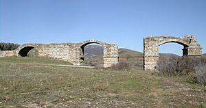
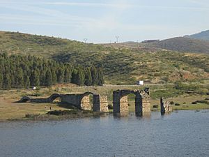
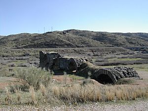
Remains of the Alconétar Bridge with its flattened arches
|
|
| Crosses | Tagus |
| Locale | Garrovillas de Alconétar, Cáceres Province, Extremadura, Spain |
| Heritage status | Listed as cultural heritage of Spain |
| Characteristics | |
| Design | Segmental arch bridge |
| Material | Stone, Roman concrete |
| Total length | 290 m (950 ft) [incl. approaches] |
| Width | 6.55–6.80 m (21.5–22.3 ft) |
| Height | Minimum 12.50 m (41.0 ft) |
| Longest span | 15 m (49 ft) |
| Number of spans | Ca. 18 [incl. flood outlets] |
| History | |
| Designer | Possibly Apollodorus of Damascus |
| Construction end | Probably reign of Trajan or Hadrian (98–138 AD) |
The Alconétar Bridge (in Spanish: Puente de Alconétar), also called Puente de Mantible, was a Roman segmental arch bridge in Extremadura, Spain. This ancient bridge had special flattened arches. These arches were very wide compared to their height. This design was quite new for its time.
Experts believe the bridge was built in the early 100s AD. This was during the rule of Roman emperors Trajan or Hadrian. It might have been designed by Apollodorus of Damascus. He was a very famous architect back then.
The Alconétar Bridge was almost 300 meters (984 feet) long. It helped the Roman Via de la Plata cross the Tagus river. The Via de la Plata was a super important road. It connected the north and south of western Hispania (ancient Spain). The bridge was likely used until the Reconquista. This was a long period when Christian kingdoms took back land from Moorish rule. After that, many attempts to rebuild the bridge failed.
In 1970, the remains of the bridge were moved. They were originally on the right bank of the river. They were moved because the Alcántara reservoir was being built.
Contents
Where is the Alconétar Bridge?
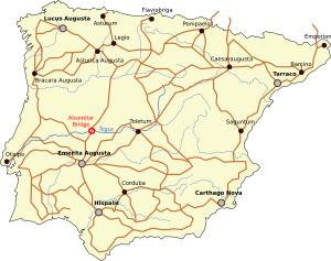
The historic Alconétar Bridge is in the Cáceres Province of Spain. It's in the Extremadura region. It crossed the Tagus river, near where the Almonte river joins it. Don't mix it up with the much bigger Alcántara Bridge further downstream!
Today, a modern highway and railway cross the Tagus nearby. This shows how important this spot has always been for travel. In 1970, the bridge's remains were moved. They are now about six kilometers (3.7 miles) north of their original spot. They are close to the town of Garrovillas de Alconétar.
In ancient times, the Alconétar Bridge was part of a Roman road. This road was called Iter ab Emerita Caesaraugustam. It later became known as the Via de la Plata. This road was a major route across Spain. It went from Mérida in the south to Astorga in the northwest.
The Roman emperor Augustus and later rulers built these roads. They helped the Roman army control the area. They also made it easier to get silver and gold from Spanish mines. Along the Via de la Plata, there are remains of four other ancient bridges. One of these is over the Tormes river.
Near the Alconétar Bridge, there was a Roman rest stop. It was called Turmulus. These stops were placed at regular distances along the road.
History of the Bridge
We don't know the exact date the Alconétar Bridge was built. This is because there are no old writings or signs about it. But its unique flattened arches suggest it was built in the early 100s AD. This was during the time of emperors Trajan (98–117 AD) or Hadrian (117–138 AD). This type of arch was common then.
Both emperors were born in a Roman province in southern Spain. Trajan ordered repairs to the Iter ab Emerita Caesaraugustam road. This happened when he became emperor. Trajan's main architect, Apollodorus of Damascus, often used flattened arches. He used them in famous projects like Trajan's Forum. He also used them in Trajan's Bridge, a huge bridge over the Danube river.
Writers from the Moorish period didn't mention the Alconétar Bridge. But they did write about the Roman bridge of Alcántara. The Alconétar Bridge is sometimes called Puente de Mantible by local people. This name comes from old legends about Charlemagne.
The bridge was probably used until the Reconquista. During this time, the Tagus river was a border. There were many fights between Christian and Moorish groups. These battles might have damaged the bridge. Another idea is that the river water started to wear away its foundations.
The Alconétar Bridge is first mentioned in records from 1231 and 1257. These records say it was still in use. The Knights Templar might have repaired it. They controlled the bridge and the nearby village then. The arches we see today (numbers 1 and 3) were not built by the Romans. They might be from this period.
By about 1340, the bridge seemed unusable again. So, people had to use a ferry to cross the river. In the Middle Ages, a fortress was built at the old rest stop. Its tower, made from Roman stones, can be seen when the Alcántara reservoir water is low.
Many attempts to fix the bridge in the early modern era failed. In 1553, an architect named Rodrigo Gil de Hontañón estimated it would cost a lot to rebuild. But his plans were never carried out. Other plans in the 1560s and 1570s also never happened.
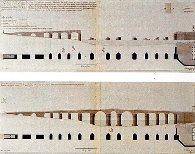
In the 1700s, two more tries to repair the bridge failed. A military engineer named José García Galiano planned a full rebuild in the 1760s. His drawing showed that only the arches on the right bank were left. This was also shown in a drawing from 1797 by Fernando Rodríguez.
A civil engineer named Antonio Prieto studied the bridge in 1925. His survey helped scientists understand the bridge's condition before it was moved in 1970. The Alconétar Bridge has been a "historical heritage" site since 1931.
How the Bridge Was Built
The Alconétar Bridge was special because of its flattened, or segmental, arches. This was unusual for ancient bridges. Most Roman bridges had semi-circular arches. According to Prieto, the bridge had sixteen arches. This doesn't include the flood openings on the right side.
The bridge was 290 meters (951 feet) long in total. About 190 meters (623 feet) of this length crossed the river when the water was low. The bridge's piers (the supports in the water) were about 4.4 meters (14.4 feet) thick.
Most of the bridge that survived was on the right bank of the Tagus. This is where the river current was weaker. Some pier stumps were in the middle of the river. On the left bank, two piers and the end support remained. The parts of the bridge that were moved to safety included:
- The right bridge ramp with two arch-shaped flood openings.
- Piers 1, 2, and 3, with parts of 4 and 6.
- Arches 1 and 3.
Other small parts were covered by the Alcántara reservoir in 1970.
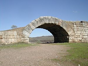
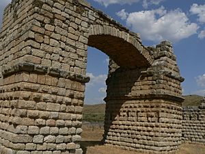
The ramp leading to the bridge is 42 meters (138 feet) long. It is between 6.55 and 6.80 meters (21.5-22.3 feet) wide. Its two flattened arches are Roman. The stones fit together perfectly. The arch stones are very wide (1.20 meters or 3.9 feet). This is quite large for the arch size.
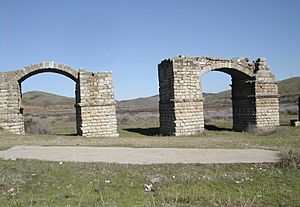
However, the two surviving bridge arches (numbers 1 and 3) are not Roman. They were built later, possibly by the Knights Templar. The upper parts of the first two piers were also rebuilt later. They might have supported a drawbridge or a tower.
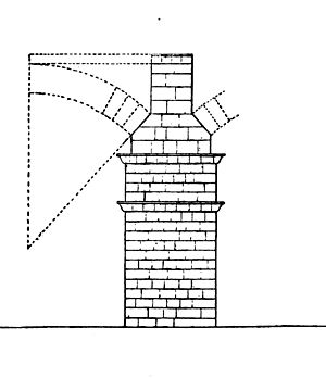
But the third pier still looks like it did in Roman times. It is 12.50 meters (41 feet) tall. Its stones are carefully cut. This pier gives us the best idea of what the original Roman bridge looked like. We can figure out how high the Roman arches were. This is based on the angles of the stone supports. The third arch was originally a circular section of 95 degrees. This means the Roman arches were about four to five times wider than they were high.
This bridge, along with others like the Limyra Bridge, is one of the oldest flattened arch bridges in the world. It shows that Roman bridge builders knew a lot about these types of arches. This was not widely believed before.
The piers get slightly thicker towards the middle of the river. Their distances also increase. The fifth pier is called "Bishop's table." It is the largest and might be from the Middle Ages. It could have been a base for a watchtower. All five piers have pointed ends facing upstream. These helped cut through the water.
The piers were built with local granite stones. They were laid without mortar or iron ties. The inside of the piers and ramps was filled with Roman concrete. This was a common way to build Roman bridges. The flattened arches made the bridge look long and flat.
Measurements Over Time
| Bridge part | Galiano (around 1770) | Rodríguez (1797) | Prieto (1925) | Durán (2004) |
|---|---|---|---|---|
| Span 1st floodway | 6.86 m (22.5 ft) | 7.04 m (23.1 ft) | 7.00 m (22.97 ft) | 6.95 m (22.8 ft) |
| Ramp thickness | 10.60 m (34.8 ft) | 11.63 m (38.2 ft) | 12.00 m (39.37 ft) | 14.00 m (45.93 ft) |
| Span 2nd floodway | 7.40 m (24.3 ft) | 7.10 m (23.3 ft) | 7.50 m (24.6 ft) | 7.40 m (24.3 ft) |
| Ramp thickness | 12.90 m (42.3 ft) | 11.65 m (38.2 ft) | 13.00 m (42.65 ft) | 13.50 m (44.3 ft) |
| Span 1st arch | 7.50 m (24.6 ft) | 7.62 m (25.0 ft) | 7.30 m (24.0 ft) | 7.30 m (24.0 ft) |
| Thickness 1st pier | 5.60 m (18.4 ft) | 4.17 m (13.7 ft) | 4.25 m (13.9 ft) | 4.25 m (13.9 ft) |
| Span 2nd arch | 9.00 m (29.53 ft) | 8.44 m (27.7 ft) | 8.20 m (26.9 ft) | 8.10 m (26.6 ft) |
| Thickness 2nd pier | 5.60 m (18.4 ft) | 4.19 m (13.7 ft) | 4.25 m (13.9 ft) | 4.45 m (14.6 ft) |
| Span 3rd arch | 9.86 m (32.3 ft) | 8.92 m (29.3 ft) | 8.95 m (29.4 ft) | 8.50 m (27.9 ft) |
| Thickness 3rd pier | 5.50 m (18.0 ft) | 4.21 m (13.8 ft) | 4.25 m (13.9 ft) | 4.55 m (14.9 ft) |
| Span 4th arch | 10.10 m (33.1 ft) | 10.32 m (33.9 ft) | 10.15 m (33.3 ft) | 10.20 m (33.5 ft) |
| Thickness 4th pier | 4.81 m (15.8 ft) | 4.80 m (15.7 ft) | ||
| Span 5th arch | 12.03 m (39.5 ft) | 11.00 m (36.09 ft) | ||
| Thickness 5th pier | 6.21 m (20.4 ft) | |||
| Span 6th arch | 16.72 m (54.9 ft) | 12.00 m (39.37 ft) | ||
| Thickness 6th pier | 6.21 m (20.4 ft) | |||
| Span 7th arch | 8.92 m (29.3 ft) | 13.00 m (42.65 ft) | ||
| Thickness 7th pier | 6.21 m (20.4 ft) | |||
| Span 8th arch | 16.74 m (54.9 ft) | 14.00 m (45.93 ft) | ||
| Thickness 8th pier | 6.21 m (20.4 ft) | |||
| Span 9th arch | 11.93 m (39.1 ft) | 15.00 m (49.21 ft) | ||
| Thickness 9th pier | 4.79 m (15.7 ft) | |||
| Span 10th arch | 10.22 m (33.5 ft) | 14.00 m (45.93 ft) | ||
| Thickness 10th pier | 4.19 m (13.7 ft) | |||
| Span 11th arch | 8.82 m (28.9 ft) | 13.00 m (42.65 ft) | ||
| Thickness 11th pier | 4.19 m (13.7 ft) | |||
| Span 12th arch | 8.38 m (27.5 ft) | 12.00 m (39.37 ft) | ||
| Thickness 12th pier | 4.19 m (13.7 ft) | |||
| Span 13th arch | 11.00 m (36.09 ft) | |||
| Thickness 13th pier | ||||
| Span 14th arch | 10.00 m (32.81 ft) | |||
| Thickness 14th pier | ||||
| Span 15th arch | 9.30 m (30.5 ft) | |||
| Thickness 15th pier | ||||
| Span 16th arch | 9.10 m (29.9 ft) |
See Also
 In Spanish: Puente de Alconétar para niños
- List of Roman bridges
- Limyra Bridge
Images for kids
Annotations
 | Emma Amos |
 | Edward Mitchell Bannister |
 | Larry D. Alexander |
 | Ernie Barnes |


