Alkali Lake (Oregon) facts for kids
Quick facts for kids Alkali Lake |
|
|---|---|

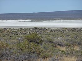
Alkali Lake dry lakebed and surrounding desert
|
|
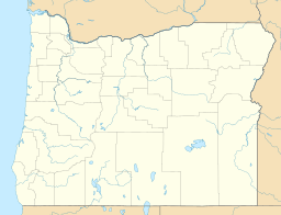
| Location | Lake County, Oregon |
| Coordinates | 42°58′38″N 120°01′41″W / 42.97722°N 120.02806°W |
| Lake type | seasonal, alkali |
| Basin countries | United States |
| Surface elevation | 4,332 ft (1,320 m) |
Alkali Lake is a unique natural area in Lake County, Oregon, United States. It's a type of lake called an endorheic basin, which means water flows into it but doesn't flow out to rivers or oceans. Instead, the water either sinks into the ground or evaporates.
This special lake is part of the Alkali Subbasin. This area is within the Summer Lake Basin watershed in southeastern Oregon. You can find it about 26 miles east of Christmas Valley, Oregon. It's also northeast of Lake Abert and right next to Abert Rim and Highway 395.
Long ago, Alkali Lake was much bigger and deeper. Scientists think it might have been as deep as 270 feet (82.5 meters). It could have covered about 1,448 square miles (2,331 square kilometers). Over time, the amount of water in the lake has changed a lot. Recently, it has been getting drier.
One interesting thing about Alkali Lake is its water. When it has water, it contains a lot of dissolved alkaline salts. These salts can make up about 10% of the water's total weight. This is why it's called "Alkali" Lake.
Plants Around Alkali Lake
Even though Alkali Lake is often dry, many plants grow in the sand dunes nearby. These plants are tough and can survive in this dry environment. Here are some of the plant families and specific plants you might find:
- Buckwheat Family
- Goosefoot Family
- Mustard Family
- Stanleya or Guillenia sp.
- Evening-primrose family
- Desert Evening-primrose
- Parsley Family
- Rhysopterus plurijugus
- Phlox Family
- Great Basin Gilia
- Borage Family
- Matted Cryptantha
- Sunflower Family
- Desert Pincushion
- Gray Rabbitbrush
- Showy Townsend Daisy
Climate at Alkali Lake
The weather at Alkali Lake is known as a steppe climate. This type of climate is often found in dry grasslands. It has hot summers and cold winters. It doesn't get a lot of rain. On climate maps, this is usually shown as "BSk" using the Köppen Climate Classification system.
| Climate data for Alkali Lake | |||||||||||||
|---|---|---|---|---|---|---|---|---|---|---|---|---|---|
| Month | Jan | Feb | Mar | Apr | May | Jun | Jul | Aug | Sep | Oct | Nov | Dec | Year |
| Record high °F (°C) | 63 (17) |
72 (22) |
78 (26) |
88 (31) |
97 (36) |
100 (38) |
108 (42) |
105 (41) |
101 (38) |
90 (32) |
75 (24) |
69 (21) |
108 (42) |
| Mean daily maximum °F (°C) | 42.2 (5.7) |
46.1 (7.8) |
51.2 (10.7) |
59.1 (15.1) |
69.1 (20.6) |
77.9 (25.5) |
87.7 (30.9) |
86.4 (30.2) |
78.1 (25.6) |
65.8 (18.8) |
49.9 (9.9) |
41.9 (5.5) |
63 (17) |
| Mean daily minimum °F (°C) | 19.2 (−7.1) |
22.5 (−5.3) |
25.1 (−3.8) |
28.7 (−1.8) |
35 (2) |
42.2 (5.7) |
46.8 (8.2) |
45.5 (7.5) |
37.1 (2.8) |
29.6 (−1.3) |
24.4 (−4.2) |
18.8 (−7.3) |
31.2 (−0.4) |
| Record low °F (°C) | −38 (−39) |
−26 (−32) |
−11 (−24) |
6 (−14) |
4 (−16) |
23 (−5) |
30 (−1) |
26 (−3) |
14 (−10) |
−2 (−19) |
−10 (−23) |
−33 (−36) |
−38 (−39) |
| Average precipitation inches (mm) | 0.61 (15) |
0.54 (14) |
0.77 (20) |
0.84 (21) |
1.22 (31) |
1 (25) |
0.48 (12) |
0.64 (16) |
0.48 (12) |
0.69 (18) |
0.73 (19) |
0.66 (17) |
8.65 (220) |
| Average snowfall inches (cm) | 2.9 (7.4) |
1.8 (4.6) |
1.8 (4.6) |
1.4 (3.6) |
0.5 (1.3) |
0.1 (0.25) |
0 (0) |
0 (0) |
0 (0) |
0.2 (0.51) |
2 (5.1) |
3.8 (9.7) |
14.4 (37) |
| Average precipitation days | 5 | 5 | 7 | 6 | 6 | 5 | 2 | 3 | 3 | 4 | 6 | 6 | 58 |
 | William L. Dawson |
 | W. E. B. Du Bois |
 | Harry Belafonte |


