Almond, New York facts for kids
Quick facts for kids
Almond
|
|
|---|---|

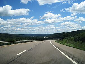
Eastbound I-86 in Almond
|
|
| Country | United States |
| State | New York |
| County | Allegany County |
| Incorporated | 1821 |
| Area | |
| • Total | 45.78 sq mi (118.58 km2) |
| • Land | 45.72 sq mi (118.41 km2) |
| • Water | 0.07 sq mi (0.17 km2) |
| Elevation | 2,051 ft (625 m) |
| Population
(2020)
|
|
| • Total | 1,526 |
| • Estimate
(2021)
|
1,511 |
| • Density | 34.04/sq mi (13.14/km2) |
| Time zone | UTC-5 (EST) |
| • Summer (DST) | UTC-4 (EDT) |
| ZIP code |
14804
|
| Area code(s) | 607 |
| FIPS code | 36-003-01451 |
Almond is a small town in Allegany County, New York, United States. In 2020, about 1,526 people lived there.
The Town of Almond is on the eastern side of Allegany County. It has a village also called Almond. The town is located west of Hornell. You can reach it from Interstate 86 at Exit 33 or by using New York State Route 21.
Contents
History of Almond
The first people settled in the Almond area around 1796, near a place called Karrdale. When Allegany County was created in 1806, Almond was part of the Town of Alfred.
The Town of Almond was officially formed in 1821. Later, parts of Almond were used to create other towns. These new towns were West Almond and Birdsall.
The town's name, Almond, comes from a place in Scotland. It is not named after the nut. The name is pronounced with the same "A" sound as nearby towns like Alfred and Angelica.
Almond Historical Society and Museum
The Almond Historical Society runs a museum. It is located at the Hagadorn House. This house was built in 1830. It has an old fireplace and a stone oven.
The Hagadorn House became a museum in 1971. It displays old furniture, clothes, tools, and art. The Historical Society also keeps family records. You can visit the museum and archives on Fridays. They also have special open houses.
Almond Library
The Almond 20th Century Club Library started in 1904. A group of women created a reading circle. Today, the Library offers many things. It has computers, free Wi-Fi, and a large collection of books. You can also find audiobooks and DVDs there.
The library is part of the Southern Tier Library System. It hosts story times for kids. There is also a book club for adults. The library's building was built in 1912. It is an important part of the town.
Geography of Almond
Almond is a very scenic area. It has many long, wooded hills. Homes and farms are found in the valleys. The town covers about 45.8 square miles (118.7 km²). Most of this area is land.
The eastern border of Almond is next to Hornellsville in Steuben County. Burns is to the north. Alfred is to the south. West Almond and Birdsall are to the west.
Major roads like the Southern Tier Expressway pass through Almond. This includes Interstate 86 and New York State Route 17. New York State Route 21 also goes through the town.
Canacadea Creek flows through the eastern part of Almond. It joins with other creeks. Then it flows out of the town towards the Canisteo River.
People in Almond
| Historical population | |||
|---|---|---|---|
| Census | Pop. | %± | |
| 1830 | 1,804 | — | |
| 1840 | 1,434 | −20.5% | |
| 1850 | 1,914 | 33.5% | |
| 1860 | 1,739 | −9.1% | |
| 1870 | 1,686 | −3.0% | |
| 1880 | 1,567 | −7.1% | |
| 1890 | 1,419 | −9.4% | |
| 1900 | 1,436 | 1.2% | |
| 1910 | 1,297 | −9.7% | |
| 1920 | 1,121 | −13.6% | |
| 1930 | 1,101 | −1.8% | |
| 1940 | 1,234 | 12.1% | |
| 1950 | 1,331 | 7.9% | |
| 1960 | 1,373 | 3.2% | |
| 1970 | 1,524 | 11.0% | |
| 1980 | 1,671 | 9.6% | |
| 1990 | 1,640 | −1.9% | |
| 2000 | 1,604 | −2.2% | |
| 2010 | 1,633 | 1.8% | |
| 2020 | 1,526 | −6.6% | |
| 2021 (est.) | 1,511 | −7.5% | |
| U.S. Decennial Census | |||
In 2000, there were 1,604 people living in Almond. There were 632 households. About 32.6% of these households had children under 18. The average household had 2.54 people.
The population was spread out by age. About 26.4% were under 18. About 11.8% were 65 or older. The average age was 39 years.
The local public school is Alfred-Almond Central School. It is known as one of the top schools in western New York. You can learn more at Alfred-Almond Junior-Senior High School. There is also a strong community for families who homeschool their children.
Places in the Town of Almond
- Almond – This is the main village. It is partly in Steuben County.
- Bishopville – A small community on County Route 32.
- Canacadea Creek – A stream in the eastern part of the town.
- Karrdale – A community near the western town line.
- Karr Valley Creek – A stream that runs near the Southern Tier Expressway.
- McHenry Valley - A valley that goes southwest from the Village.
- North Almond – A community near the northern town line.
- Sand Hill – A place west of Almond village.
- Turnpike Road - An old road that used to go from Bath, NY.
Notable people
- Cora Belle Brewster (1859–?), a doctor and writer.
- Mandana Coleman Thorp (1843–1916), a Civil War nurse and singer.
See also
 In Spanish: Almond (pueblo) para niños
 | Dorothy Vaughan |
 | Charles Henry Turner |
 | Hildrus Poindexter |
 | Henry Cecil McBay |


