Laird Township, Michigan facts for kids
Quick facts for kids
Laird Township, Michigan
|
|
|---|---|

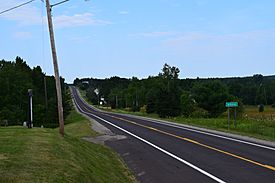
Community of Nisula along M-38
|
|

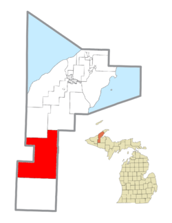
Location within Houghton County
|
|
| Country | United States |
| State | Michigan |
| County | Houghton |
| Area | |
| • Total | 189.4 sq mi (490.5 km2) |
| • Land | 188.1 sq mi (487.1 km2) |
| • Water | 1.3 sq mi (3.4 km2) |
| Elevation | 1,030 ft (314 m) |
| Population
(2020)
|
|
| • Total | 487 |
| • Density | 2.571/sq mi (0.9929/km2) |
| Time zone | UTC-5 (Eastern (EST)) |
| • Summer (DST) | UTC-4 (EDT) |
| ZIP code(s) | |
| Area code(s) | 906 |
| FIPS code | 26-44220 |
| GNIS feature ID | 1626571 |
Laird Township is a civil township located in Houghton County, in the U.S. state of Michigan. A civil township is a type of local government area. According to the 2020 census, 487 people live in Laird Township.
Contents
Communities in Laird Township
Laird Township is home to several smaller communities. These are often called "unincorporated communities." This means they are not officially organized as a city or village.
Alston Community History
- Alston is one of these communities. It started with a rural post office in August 1887. This post office was first named Laird.
- The post office closed for a short time in 1888 but reopened later that year.
- In April 1902, J.V. Alston became the postmaster. The community and its post office were then renamed Alston after him. The post office served the area until June 1957.
Other Local Communities
- Bishop is another unincorporated community found within the township.
- Motley is also an unincorporated community in Laird Township.
- Nisula is an unincorporated community that is part of the township.
- Pori is an unincorporated community. It is sometimes also known by the name "Plato."
Geography of Laird Township
The geography of a place describes its land and water features. Laird Township covers a total area of about 189.4 square miles (490.5 square kilometers).
Land and Water Areas
- Most of this area, about 188.1 square miles (487.1 square kilometers), is land.
- A smaller part, about 1.3 square miles (3.4 square kilometers), is water. This means that about 0.69% of the township's total area is covered by water.
Population and People
Understanding the demographics helps us learn about the people who live in Laird Township.
Population Changes
- In the year 2000, there were 634 people living in the township.
- By the 2020 census, the population had changed to 487 people.
Household Information
- In 2000, there were 253 households in Laird Township. A household means all the people living in one home.
- About 28.5% of these households had children under 18 living with them.
- Many households, about 58.9%, were married couples living together.
Age Groups in the Township
- The population in 2000 was spread across different age groups.
- About 25.9% of the people were under 18 years old.
- About 14.2% of the people were 65 years old or older.
- The median age was 38 years. This means half the people were younger than 38 and half were older.
Ancestry of Residents
- According to the 2000 census, many residents had Finnish ancestry, about 60.1%.
- Other common ancestries included German (13.7%) and French (5.3%).
See also
 In Spanish: Municipio de Laird (Míchigan) para niños

All content from Kiddle encyclopedia articles (including the article images and facts) can be freely used under Attribution-ShareAlike license, unless stated otherwise. Cite this article:
Laird Township, Michigan Facts for Kids. Kiddle Encyclopedia.


