
Alto Paraná Department facts for kids
Quick facts for kids
Alto Paraná
|
|||
|---|---|---|---|

Skyline of Ciudad del Este
|
|||
|
|||

Location of Alto Paraná, in red, in Paraguay
|
|||
| Country | |||
| Region | Oriental | ||
| Capital | Ciudad del Este | ||
| Districts | 22 | ||
| Area | |||
| • Total | 14,895 km2 (5,751 sq mi) | ||
| Population
(2012)
|
|||
| • Total | 785,747 | ||
| • Density | 52.7524/km2 (136.628/sq mi) | ||
| Demonym(s) | Altoparanaense | ||
| Time zone | UTC-04 (AST) | ||
| • Summer (DST) | UTC-03 (ADT) | ||
| ISO 3166 code | PY-10 | ||
| Website | Official website: http://www.altoparana.gov.py/ | ||


The Alto Paraná department (which means Upper Paraná in Spanish) is a region in Paraguay. It is one of the many departments that make up the country. The main city and capital of this department is Ciudad del Este.
Its special code, used around the world, is PY-10. This code helps identify it easily.
Contents
Geography
The Alto Paraná department is located in the central eastern part of Paraguay. It is in the eastern area of the Oriental region of the country.
This department covers an area of about 14,895 square kilometers (5,751 square miles). In 2012, about 785,747 people lived here. This means there were about 52.7 people living in each square kilometer.
What Borders Alto Paraná?
Alto Paraná shares its borders with several other places:
- To the north, it borders the Canindeyú Department.
- To the south, it is next to the Itapúa department.
- To the east, it shares a border with two other countries: Brazil and Argentina.
- To the west, it borders the Caaguazú and Caazapá departments.
 |
Canindeyú Department | Brazil | |
|
| Caaguazú | ||||
| Caazapá | Itapúa | Argentina |
Rivers in the Region
The most important river in the Alto Paraná department is the Paraná river. Another important river is the Acaray, which flows into the Paraná. These rivers are vital for the region's water supply and nature.
Climate and Weather
Ciudad del Este, the capital city, has a humid subtropical climate. This means it's usually mild and doesn't have a dry season. It gets rain throughout the whole year. This type of climate is known as Cfa in the Köppen climate classification system.
On average, Ciudad del Este receives about 1,694.5 millimeters (66.7 inches) of rainfall each year. January is usually the wettest month, with about 184.1 millimeters (7.2 inches) of rain. October is also quite rainy, with about 176 millimeters (6.9 inches).
The driest month is typically July, with about 90.6 millimeters (3.6 inches) of rain. August is also drier, with about 115 millimeters (4.5 inches).
The department is generally a warm place. The average temperature for the entire year is about 21.5°C (70.7°F). The warmest month is usually January, with an average temperature of 26.1°C (79.0°F). The coolest month is typically June, with an average temperature of 16.3°C (61.3°F).
Districts
The Alto Paraná department is divided into 22 smaller areas called districts. Each district has its own local government. The capital city, Ciudad del Este, is one of these districts.

Related pages
Images for kids
-
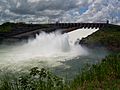
Itaipú Hydroelectric Dam

See also
 In Spanish: Departamento de Alto Paraná para niños
