Canindeyú Department facts for kids
Quick facts for kids
Canindeyú
Departamento de Canindeyú
|
|||
|---|---|---|---|

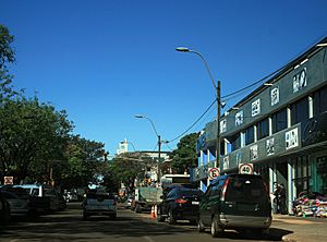
Salto del Guaira downtown
|
|||
|
|||

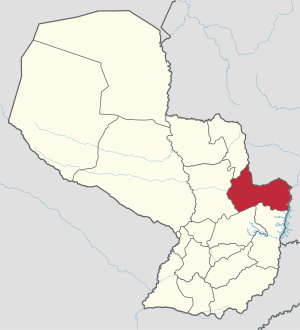
Location of Canindeyu, in red, in Paraguay
|
|||
| Country | |||
| Region | Oriental | ||
| Capital | Salto del Guairá | ||
| Boroughs | 12 (See list) | ||
| Area | |||
| • Total | 14,667 km2 (5,663 sq mi) | ||
| Population
(2012)
|
|||
| • Total | 191,447 | ||
| • Density | 13.0529/km2 (33.8069/sq mi) | ||
| Time zone | UTC-04 (AST) | ||
| • Summer (DST) | UTC-03 (ADT) | ||
| ISO 3166 code | PY-14 | ||
The Canindeyú department is a region in Paraguay. Its capital city is Salto del Guairá. This department is known by a special code, PY-14.
The name Canindeyú comes from an old language called Tupi. Kaninde means "macaw," and ju means "yellow." So, the name refers to the blue-and-yellow macaw, a beautiful bird with blue and yellow feathers.
Contents
Geography of Canindeyú
The Canindeyú department is located in the northeast part of Paraguay's Oriental region. It covers a large area of about 14,667 square kilometers (5,663 square miles). In 2012, about 191,447 people lived there. This means it has about 13 people per square kilometer.
Two important mountain ranges, Amambay and Mbaracayú, are found in this department. They also form part of the border with Brazil.
Where is Canindeyú?
Canindeyú shares its borders with several other places:
- To the north: The Amambay department.
- To the east: Brazil.
- To the south: The Caaguazú and Alto Paraná departments.
- To the west: The San Pedro department.
 |
Amambay | Brazil |  |
|
| San Pedro | Brazil | |||
| Caaguazú | Alto Paraná |
Canindeyú's Climate
In 2012, the city of Salto del Guairá received about 1,354 millimeters (53.3 inches) of rain. April was the wettest month, with about 238 millimeters (9.4 inches) of rain. August was the driest, with only about 3 millimeters (0.1 inches).
The average temperature in Salto del Guairá in 2012 was about 22.8°C (73°F). February was the warmest month, averaging 26.6°C (79.9°F). July was the coolest, with an average temperature of 17.3°C (63.1°F).
Districts
The Canindeyú department is divided into 13 smaller areas called districts. Each district has its own area and population.
| No. | Districts | Area (km²) |
Population (2015) |
Density |
|---|---|---|---|---|
| 1 | Corpus Christi | 304.93 | 9,769 | 32.0 |
| 2 | Curuguaty | 2,971.45 | 51,675 | 17.4 |
| 3 | General Francisco Caballero Álvarez | 748.41 | 11,652 | 15.6 |
| 4 | Itanará | 901.15 | 3,129 | 3.5 |
| 5 | Katueté | 587.44 | 8,500 | 14.5 |
| 6 | La Paloma | 635.41 | 8,608 | 13.5 |
| 7 | Nueva Esperanza | 1,319.59 | 12,628 | 9.6 |
| 8 | Salto del Guairá | 1,748.86 | 29,593 | 16.9 |
| 9 | Yasy Cañy | 753.48 | 27,041 | 35.9 |
| 10 | Yby Pytá | 1,129.69 | 11,626 | 10.3 |
| 11 | Ybyrarovaná | 1,101.48 | 13,855 | 12.6 |
| 12 | Ypejhú | 874.94 | 8,336 | 9.5 |
| 13 | Villa Ygatimí | 1,959.58 | 16,224 | 8.3 |
Economy
The main way people make a living in Canindeyú is through farming. Farmers grow important crops like soybean, tobacco, and maize (corn). Raising cattle (like cows) is also a big part of the local economy.
Related pages
See also
In Spanish: Departamento de Canindeyú para niños
 | Dorothy Vaughan |
 | Charles Henry Turner |
 | Hildrus Poindexter |
 | Henry Cecil McBay |


