
San Pedro Department, Paraguay facts for kids
Quick facts for kids
San Pedro
Departamento de San Pedro
|
|||
|---|---|---|---|

A toll by the entrance of San Pedro
|
|||
|
|||

Location of San Pedro, in red, in Paraguay
|
|||
| Country | |||
| Region | Oriental | ||
| Capital | San Pedro de Ycuamandiyú | ||
| Boroughs | 20 (See list) | ||
| Area | |||
| • Total | 20,002 km2 (7,723 sq mi) | ||
| Population
(2012)
|
|||
| • Total | 360,094 | ||
| • Density | 18.0029/km2 (46.6273/sq mi) | ||
| Demonym(s) | Sampedrano | ||
| Time zone | UTC-04 (AST) | ||
| • Summer (DST) | UTC-03 (ADT) | ||
| ISO 3166 code | PY-02 | ||
| Website | Official website: http://sanpedro.gov.py/ | ||


The San Pedro department (Spanish: Departamento de San Pedro) is a region in Paraguay. It is like a state or province. Its main city, or capital, is San Pedro de Ycuamandiyú. The name "San Pedro" means "Saint Peter" and comes from its capital city. Its special code is PY-02.
Contents
History of San Pedro
In the 1600s and 1700s, there were some challenges in the San Pedro area. To help the region grow and become stronger, three towns were founded. These were San Estanislao in 1749, and Villa del Rosario and San Pedro de Ycuamandiyú both in 1786.
San Pedro became the second department in Paraguay by law in 1906. At first, it included many areas like Itacurubí del Rosario, Santa Rosa del Aguaray, and even the land that is now the Canindeyú department. Its final borders were set by a law on December 26, 1973.
Geography of San Pedro
The San Pedro department is located in the north-central part of Paraguay's Oriental region. It covers a large area of 20,002 km2 (7,723 sq mi). This makes it the biggest department in the Oriental region. About 360,094 people live here, which means there are about 18.0 people per square kilometer.
Neighboring Regions
San Pedro shares its borders with several other departments:
- To the north: Concepción and Amambay departments.
- To the east: Amambay and Canindeyú departments.
- To the south: Caaguazú and Cordillera departments.
- To the west: The Paraguay river separates it from the Presidente Hayes department.
 |
Concepción department | Amambay department | |
|
| Presidente Hayes department | Canindeyú department | |||
| Caaguazú and Cordillera departments |
Rivers in San Pedro
The most important river in the department is the Paraguay River. It forms the western border of San Pedro.
Other important rivers include the Jejuí Guazú, which is 327 km (203 mi) long. The Ypané river is also significant, measuring 323 km (201 mi) in length.
Climate in San Pedro
In 2014, the city of San Pedro de Ycuamandiyú received about 1,783.0 mm (70.2 in) of rain in total. April was the wettest month, with 353.4 mm (13.9 in) of rain. August was the driest month, with no rain recorded.
The average temperature in San Pedro de Ycuamandiyú in 2014 was 23.7 °C (74.7 °F). February was the warmest month, with an average temperature of 34.7 °C (94.5 °F). July was the coolest month, with an average temperature of 13.7 °C (56.7 °F).
Districts
The San Pedro department is divided into 20 smaller areas called districts. Each district has its own local government.
| No. | Districts | Area (km²) |
Population (2015) |
Density |
|---|---|---|---|---|
| 1 | Antequera | 480 | 2,119 | 4.4 |
| 2 | Capiibary | 826 | 22,691 | 27.5 |
| 3 | Choré | 965 | 15,402 | 16.0 |
| 4 | General Elizardo Aquino | 816 | 12,773 | 15.7 |
| 5 | General Isidoro Resquín | 1,075 | 13,285 | 12.4 |
| 6 | Guayaibí | 1,460 | 15,859 | 10.9 |
| 7 | Itacurubí del Rosario | 769 | 6,137 | 8.0 |
| 8 | Liberación | 587 | 12,383 | 21.1 |
| 9 | Lima | 658 | 6,404 | 9.7 |
| 10 | Nueva Germania | 657 | 3,391 | 5.2 |
| 11 | San Estanislao | 1,700 | 27,203 | 16.0 |
| 12 | San Pablo | 320 | 2,016 | 6.3 |
| 13 | San Pedro de Ycuamandiyú | 3,176 | 17,896 | 5.6 |
| 14 | Santa Rosa del Aguaray | 1,572 | 19,415 | 12.4 |
| 15 | Tacuatí | 2,283 | 7,900 | 3.5 |
| 16 | Unión | 587 | 3,780 | 6.4 |
| 17 | Veinticinco de Diciembre | 995 | 5,414 | 5.4 |
| 18 | Villa del Rosario | 1,975 | 5,734 | 2.9 |
| 19 | Yataity del Norte | 316 | 6,753 | 21.4 |
| 20 | Yrybucuá | 509 | 7,873 | 15.5 |

Images for kids
-
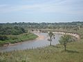
Yhaguy river
-
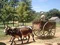
A cart in Veinticinco de Diciembre San Pedro department
-

Sunset in Laguna Blanca, Santa Rosa.


See also
 In Spanish: Departamento de San Pedro (Paraguay) para niños
