
Cordillera Department facts for kids
Quick facts for kids
Cordillera
Departamento de Cordillera
|
|||
|---|---|---|---|

Basilica of Caacupé
|
|||
|
|||

Location of Cordillera, in red, in Paraguay
|
|||
| Country | |||
| Region | Oriental | ||
| Capital | Caacupé | ||
| Boroughs | 20 (See list) | ||
| Area | |||
| • Total | 4,948 km2 (1,910 sq mi) | ||
| Population
(2012)
|
|||
| • Total | 282,981 | ||
| • Density | 57.191/km2 (148.124/sq mi) | ||
| Demonym(s) | Cordillerano | ||
| Time zone | UTC-04 (AST) | ||
| • Summer (DST) | UTC-03 (ADT) | ||
| ISO 3166 code | PY-03 | ||
| Website | Official website: http://www.gobernacioncordillera.gov.py/ | ||


The Cordillera department (which means Mountain Range department in Spanish) is a special area in Paraguay. Think of it like a state or a big region. Its main city, or capital, is Caacupé. It also has a special code, PY-03, which helps identify it.
Contents
Where is Cordillera?
The Cordillera department is located in the eastern part of Paraguay, called the Oriental region. It's quite large, covering about 4,948 square kilometers. In 2012, around 282,981 people lived here.
What are its neighbors?
Cordillera shares its borders with several other departments:
- To the north: San Pedro department.
- To the east: Caaguazú department.
- To the south: Paraguarí and Central departments.
- To the west: Presidente Hayes department. The Paraguay River separates these two areas.
 |
San Pedro department | |
||
| Presidente Hayes department | Caaguazú department | |||
| Central department | Paraguarí department |
Rivers and Lakes
The most important river in Cordillera is the Paraguay River. It forms the western edge of the department.
The main lake in the area is Ypacaraí.
How is Cordillera divided?
The Cordillera department is split into 20 smaller areas called districts. Each district has its own local government.
| No. | Districts | Area (km²) |
Population (2015) |
Density |
|---|---|---|---|---|
| 1 | Altos | 130 | 13,922 | 107.1 |
| 2 | Arroyos y Esteros | 537 | 23,942 | 44.6 |
| 3 | Atyrá | 145 | 16,318 | 112.5 |
| 4 | Caacupé | 145 | 53,615 | 369.8 |
| 5 | Caraguatay | 524 | 13,399 | 25.6 |
| 6 | Emboscada | 193 | 17,684 | 91.6 |
| 7 | Eusebio Ayala | 274 | 22,890 | 83.5 |
| 8 | Isla Pucú | 99 | 7,775 | 78.5 |
| 9 | Itacurubí de la Cordillera | 134 | 11,171 | 83.4 |
| 10 | Juan de Mena | 968 | 6,656 | 6.9 |
| 11 | Loma Grande | 85 | 3,426 | 40.3 |
| 12 | Mbocayaty del Yhaguy | 264 | 4,234 | 16.0 |
| 13 | Nueva Colombia | 77 | 3,879 | 50.4 |
| 14 | Piribebuy | 209 | 27,019 | 129.3 |
| 15 | Primero de Marzo | 82 | 6,675 | 81.4 |
| 16 | San Bernardino | 113 | 11,566 | 102.4 |
| 17 | San José Obrero | 197 | 4,348 | 22.1 |
| 18 | Santa Elena | 112 | 5,172 | 46.2 |
| 19 | Tobatí | 285 | 30,836 | 108.2 |
| 20 | Valenzuela | 173 | 6,785 | 39.2 |

Related Pages
Images for kids
-
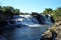
Piraretá
-
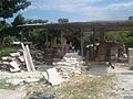
Emboscada
-
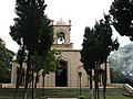
Church in the Altos district.


See also
 In Spanish: Departamento de Cordillera para niños
