
Amapala facts for kids
Quick facts for kids
Amapala
|
|
|---|---|
|
Municipality
|
|

Catholic cathedral of Amapala
|
|

Amapala
Location in Honduras
|
|
| Country | |
| Department | Valle |
| Area | |
| • Land | 75.2 km2 (29.0 sq mi) |
| Population
(2015)
|
|
| • Municipality | 12,743 |
| • Urban | 2,482 |
| Time zone | UTC−6 (Central America) |
Amapala is a town in the Valle area of Honduras. It is a municipality, which is like a local government area.
Amapala is located on El Tigre Island and other smaller islands in the Gulf of Fonseca. The total land area is about 75.2 square kilometers. In 2001, about 2,482 people lived there. Amapala used to be the main port for Honduras on the Pacific Ocean. This was because it had a naturally deep channel, even though it didn't have many modern port facilities.
Contents
History of Amapala
How Amapala Got Its Name
The island where Amapala is located is called El Tigre Island. In the 1500s, a famous pirate named Francis Drake and his crew were active around the island. Local people thought they were fierce, like wild beasts, so they called the island "Cerro de El Tigre," meaning "Tiger Hill."
The name "Amapala" itself comes from the Nahuatl language. It means "close to amates," which are a type of fig tree. Another idea is that it comes from the Goajiquiro dialect. In that language, "ama" means corn and "palha" means hill. So, it could mean "hill of corn."
Amapala's Development as a Port
Amapala was officially started in 1838. Its port was opened for trade in 1868, meaning ships could come and go freely. During the 1800s, Amapala was important for sending out gold, silver, and other valuable metals.
However, building a railway across Honduras from Puerto Cortés was very slow. This slowed down Amapala's growth. By the mid-1970s, another port called San Lorenzo on the mainland became more important than Amapala.
The Treaty of Amapala
In 1895, the countries of El Salvador, Honduras, and Nicaragua signed an agreement in Amapala. This agreement was called the Treaty of Amapala. It created a short-lived union of these countries, known as the Greater Republic of Central America.
People of Amapala
In 2013, the Amapala municipality had about 12,250 people living there. Most of the people, about 74%, were Mestizo. This means they have a mix of European and Indigenous backgrounds. About 23% were White, and about 1.5% were Black or Afro-Honduran. A small number were Indigenous or other groups.
Climate in Amapala
Amapala has a tropical savanna climate. This type of climate is often called "Aw" on climate maps. It means the area usually has a clear dry season and a wet season.
| Climate data for Amapala | |||||||||||||
|---|---|---|---|---|---|---|---|---|---|---|---|---|---|
| Month | Jan | Feb | Mar | Apr | May | Jun | Jul | Aug | Sep | Oct | Nov | Dec | Year |
| Mean daily maximum °C (°F) | 33 (92) |
33 (92) |
33 (92) |
34 (93) |
33 (91) |
32 (90) |
33 (91) |
33 (91) |
32 (89) |
32 (89) |
32 (90) |
33 (91) |
33 (91) |
| Mean daily minimum °C (°F) | 27 (80) |
27 (80) |
27 (81) |
28 (83) |
27 (81) |
27 (80) |
27 (80) |
27 (81) |
26 (79) |
27 (80) |
27 (80) |
27 (81) |
27 (80) |
| Average precipitation days | 0 | 0 | 0 | 2 | 5 | 6 | 5 | 6 | 5 | 2 | 1 | 0 | 32 |
| Source: Weatherbase | |||||||||||||
Economy
Many people in Amapala get money from family members who have moved to other countries. As of 2013, most people living in Amapala work as fishermen. About 300 people have other kinds of formal jobs.
Gallery
-
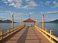
Boardwalk, Puerto de Amapala
-
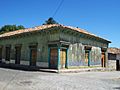
Building at La Plaza de Amapala
-
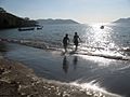
Shore at Amapala


See also
 In Spanish: Amapala para niños
