Tiger Island facts for kids
Quick facts for kids El Tigre Island |
|||||||||
|---|---|---|---|---|---|---|---|---|---|

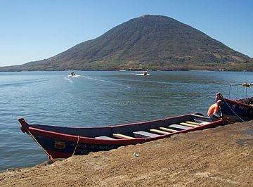
El Tigre, seen from Coyolito
|
|||||||||
| Highest point | |||||||||
| Elevation | 783 m (2,569 ft) | ||||||||
| Prominence | 783 m (2,569 ft) | ||||||||
| Geography | |||||||||
| Location | Honduras | ||||||||
| Parent range | Central America Volcanic Arc | ||||||||
| Geology | |||||||||
| Age of rock | Holocene | ||||||||
| Mountain type | Stratovolcano | ||||||||
| Last eruption | Unknown | ||||||||
|
|||||||||
El Tigre is an island located in the Gulf of Fonseca. This gulf is a large body of water found on the Pacific coast of Central America. The island itself is a stratovolcano shaped like a cone and made of a dark rock called basalt. It is the southernmost volcano in Honduras and belongs to the Valle department.
El Tigre Island, along with Isla Zacate Grande, Isla Comandante, and some tiny islets, forms the municipality of Amapala. This area covers about 75 square kilometers (29 square miles). In 2001, about 9,687 people lived there.
Sharing the Gulf of Fonseca
The Gulf of Fonseca is bordered by three countries: Honduras, El Salvador, and Nicaragua. For a long time, these three nations had a disagreement about who owned the gulf and the islands within it.
Solving the Border Dispute
In 1992, a special court called the International Court of Justice (ICJ) helped solve this problem. This court decided how the land, islands, and sea borders should be shared. The ICJ ruled that El Salvador, Honduras, and Nicaragua would share control of the Gulf of Fonseca.
Who Got Which Island?
As part of this important decision, El Salvador was given the islands of Meanguera and Meanguerita. Honduras was awarded the island of El Tigre. This ruling helped to settle the long-standing dispute peacefully.
See also
 In Spanish: El Tigre (Honduras) para niños
- List of lighthouses in Honduras
- List of volcanoes in Honduras
- List of islands of Honduras
 | Aaron Henry |
 | T. R. M. Howard |
 | Jesse Jackson |

