
Amatitlán facts for kids
Quick facts for kids
Amatitlán
|
|||
|---|---|---|---|
|
Municipality
|
|||
|
|||

Amatitlán
Location in Guatemala
|
|||
| Country | |||
| Department | Guatemala Department | ||
| Area | |||
| • Total | 44 sq mi (113 km2) | ||
| Elevation | 3,898 ft (1,188 m) | ||
| Population
(2018 census)
|
|||
| • Total | 116,711 | ||
| • Density | 2,675/sq mi (1,033/km2) | ||
| Climate | Aw | ||


Amatitlán is a town and a municipality in the Guatemala department of Guatemala. In 2018, about 98,176 people lived there. It's an important place in Guatemala.
Contents
History
Early Settlements and Spanish Influence
After the Spanish conquered the area, they wanted to teach the native people the Catholic faith. They set up special settlements called "Indian doctrines" or "reductions." The idea was for friars (religious teachers) to teach Spanish and Catholicism. Then, these settlements would become regular parishes, like those in Spain.
However, this plan didn't quite work out. The friars became very powerful and didn't always follow the Spanish government's rules. They protected their own interests. These "doctrines" grew into towns that stayed under the friars' control for a long time.
These doctrines had a few key features:
- They were mostly independent from outside control.
- A group of friars ran them.
- They often had many smaller towns or "annexes" connected to them.
Amatitlán Becomes a Department
After Central America became independent, Amatitlán became a special independent district. This happened on November 6, 1839, when Mariano Rivera Paz was the governor. The new district included Amatitlán, Palín, and Villa Nueva. It had its own local government and court.
Later, on May 8, 1866, the district was officially renamed the Amatitlán Department. This change was made by the government of Vicente Cerna y Cerna.
Changes to Amatitlán's Status
The Amatitlán Department was eventually ended by a government order on April 29, 1935. This was during the time of president general Jorge Ubico. After this, Amatitlán became a municipality within the Guatemala Department.
A Key Moment in Guatemalan History
An important event in Guatemala's history happened near Amatitlán. This was the death of Colonel Francisco Javier Arana on July 18, 1949. Arana was a powerful military leader. His death was a big turning point for Guatemala's politics in the 1940s.
His passing helped clear the way for Colonel Jacobo Árbenz Guzmán to become president in 1950. It also created a difficult situation for the president at the time, Juan José Arévalo. There were protests and disagreements within the army and among civilians.
Arana was on his way back from a presidential residence near Lake Amatitlán when he was stopped. A shooting occurred, and Arana and two others died. What exactly happened is still debated. After this, there were fights in the capital city, but the government eventually took control.
Economy
In the past, a main industry in Amatitlán was making cochineal. This is a red dye made from insects. Around 1850, Amatitlán was producing a lot of it.
Today, Amatitlán has the largest duty-free zone in Guatemala. This means goods can be brought in and out without certain taxes. Many factories, especially those that assemble clothes (called maquila factories), are located here. They employ thousands of people, often women.
The town is next to Lake Amatitlán. It's a popular spot for people from Guatemala City to visit on weekends.
Climate
Amatitlán has a tropical climate. This type of climate is known as Aw in the Köppen climate classification system. It means it's generally warm all year with a rainy season.
| Climate data for Amatitlán | |||||||||||||
|---|---|---|---|---|---|---|---|---|---|---|---|---|---|
| Month | Jan | Feb | Mar | Apr | May | Jun | Jul | Aug | Sep | Oct | Nov | Dec | Year |
| Mean daily maximum °C (°F) | 26.6 (79.9) |
27.3 (81.1) |
28.6 (83.5) |
28.6 (83.5) |
28.3 (82.9) |
26.7 (80.1) |
26.9 (80.4) |
26.9 (80.4) |
26.3 (79.3) |
26.2 (79.2) |
25.9 (78.6) |
26.0 (78.8) |
27.0 (80.6) |
| Daily mean °C (°F) | 20.7 (69.3) |
21.1 (70.0) |
22.3 (72.1) |
22.7 (72.9) |
22.9 (73.2) |
22.1 (71.8) |
22.1 (71.8) |
22.0 (71.6) |
21.7 (71.1) |
21.4 (70.5) |
20.7 (69.3) |
20.4 (68.7) |
21.7 (71.0) |
| Mean daily minimum °C (°F) | 14.9 (58.8) |
15.0 (59.0) |
16.0 (60.8) |
16.9 (62.4) |
17.5 (63.5) |
17.5 (63.5) |
17.3 (63.1) |
17.1 (62.8) |
17.1 (62.8) |
16.6 (61.9) |
15.6 (60.1) |
14.9 (58.8) |
16.4 (61.5) |
| Average precipitation mm (inches) | 1 (0.0) |
1 (0.0) |
4 (0.2) |
27 (1.1) |
122 (4.8) |
253 (10.0) |
200 (7.9) |
177 (7.0) |
237 (9.3) |
135 (5.3) |
17 (0.7) |
3 (0.1) |
1,177 (46.4) |
| Source: Climate-Data.org | |||||||||||||
Geographic Location
 |
Villa Nueva, municipality of Guatemala Department | |
||
| Sacatepéquez, department of Guatemala | Villa Canales, municipality of Guatemala Department | |||
| Villa Canales, municipality of Guatemala Department | Villa Canales, municipality of Guatemala Department |
Images for kids
-

The coat of arms for the Order of Preachers.
-
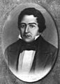
A portrait of Mariano Rivera Paz, who helped create Amatitlán as an independent district.
-
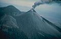
Volcán Pacaya erupting in 1976.
-
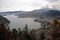
A scenic view of Lake Amatitlán from El Filón Hill.


See Also
 In Spanish: Amatitlán (Guatemala) para niños
