
Villa Canales facts for kids
Quick facts for kids
Villa Canales
|
||
|---|---|---|
|
Municipality
|
||
|
||

Villa Canales
Location in Guatemala
|
||
| Country | ||
| Department | Guatemala | |
| Area | ||
| • Municipality | 114 sq mi (295 km2) | |
| Population
(2018 census)
|
||
| • Municipality | 155,423 | |
| • Density | 1,364.6/sq mi (526.9/km2) | |
| • Urban | 124,680 | |
| Climate | Aw | |

Villa Canales is a city and municipality in the Guatemala department of Guatemala. It is located about 22 kilometers (14 miles) south of the capital, Guatemala City. In 2018, the city had a population of 124,680 people. This made it the eleventh largest city in Guatemala.
Contents
Economy in Villa Canales
The economy of Villa Canales mainly relies on farming. The city grows coffee, sugarcane, and pineapple. Villa Canales is the biggest producer of pineapple in Guatemala. This is because the nearby Pacaya Volcano makes the soil very fertile. The city has grown a lot and is now one of the most important municipalities in its department.

History of Villa Canales
Early Settlements and Spanish Rule
During the time of the Spanish colony, the Spanish government wanted to teach the native people about the Catholic faith. They created special settlements called "doctrines." These doctrines were meant to be temporary. Friars, who were religious teachers, would teach the native people Spanish and Catholicism. After a while, these settlements were supposed to become regular towns.
However, this plan did not quite work out. The friars had special permissions from the Pope. This meant they only answered to their own religious leaders, not to the Spanish government. So, the doctrines often grew and stayed under the control of the friars. They became like independent towns.
These towns were usually run by a group of friars. This helped make sure the community continued smoothly even if one friar left or died. In 1638, the religious group called the Order of Preachers organized their doctrines. The area that would become Villa Canales was part of the Amatitlán monastery's control.
Becoming a Municipality
After Central America became independent from Spain, changes happened. In 1839, a new independent area was created. It was called Amatitlán and included towns like Palín and Villa Nueva. This area was managed by a special leader.
Later, in 1866, this independent area became the Amatitlán Department. This was a bigger change, making it a more official part of the country's government.
In 1912, the area known as Pueblo Viejo became a new municipality. A municipality is like a local government area. Then, in 1915, its name was officially changed to San Joaquín Villa Canales. This was done to honor Joaquina Cabrera, the mother of the president at the time, Manuel Estrada Cabrera.
However, after President Estrada Cabrera left office in 1920, the new president, Carlos Herrera y Luna, removed all names that honored the former leader or his family. So, the municipality's name became simply «Villa Canales».
In 1935, the Amatitlán Department was officially ended by the government.
Climate
Villa Canales has a tropical climate. This type of climate is called Aw in the Köppen climate classification system. It means the area is generally warm all year with a wet season and a dry season.
| Climate data for Villa Canales | |||||||||||||
|---|---|---|---|---|---|---|---|---|---|---|---|---|---|
| Month | Jan | Feb | Mar | Apr | May | Jun | Jul | Aug | Sep | Oct | Nov | Dec | Year |
| Mean daily maximum °C (°F) | 25.8 (78.4) |
27.0 (80.6) |
28.2 (82.8) |
28.5 (83.3) |
28.2 (82.8) |
26.4 (79.5) |
26.6 (79.9) |
26.6 (79.9) |
26.0 (78.8) |
26.0 (78.8) |
25.4 (77.7) |
25.4 (77.7) |
26.7 (80.0) |
| Daily mean °C (°F) | 19.9 (67.8) |
20.7 (69.3) |
21.7 (71.1) |
22.5 (72.5) |
22.6 (72.7) |
21.7 (71.1) |
21.8 (71.2) |
21.6 (70.9) |
21.4 (70.5) |
21.2 (70.2) |
20.3 (68.5) |
19.9 (67.8) |
21.3 (70.3) |
| Mean daily minimum °C (°F) | 14.1 (57.4) |
14.4 (57.9) |
15.3 (59.5) |
16.5 (61.7) |
17.1 (62.8) |
17.1 (62.8) |
17.1 (62.8) |
16.7 (62.1) |
16.8 (62.2) |
16.4 (61.5) |
15.2 (59.4) |
14.4 (57.9) |
15.9 (60.7) |
| Average precipitation mm (inches) | 1 (0.0) |
2 (0.1) |
4 (0.2) |
26 (1.0) |
130 (5.1) |
254 (10.0) |
226 (8.9) |
195 (7.7) |
242 (9.5) |
137 (5.4) |
20 (0.8) |
5 (0.2) |
1,242 (48.9) |
| Source: Climate-Data.org | |||||||||||||
Geographic Location
Villa Canales is surrounded by other municipalities in the Guatemala Department. To the south, it borders Palín, which is a municipality in the Escuintla Department.
 |
Guatemala City | Santa Catarina Pinula | |
|
| Petapa and Amatitlán Lago Amatitlán |
Fraijanes | |||
| Palín, Escuintla Department municipality |
Images for kids
-

The coat of arms for the Order of Preachers, a religious group important in the history of the region.
-
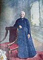
Joaquina Cabrera, mother of former president Manuel Estrada Cabrera, after whom Villa Canales was briefly named.
-
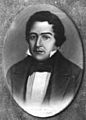
A portrait of Mariano Rivera Paz, who was a governor when the Amatitlán district was created.


See also
 In Spanish: Villa Canales para niños
