
Ambleside Roman Fort facts for kids
Quick facts for kids Ambleside Roman Fort |
|
|---|---|
 |
|

Location in Cumbria
|
|
| Known also as | Galava |
| Place in the Roman world | |
| Province | Britannia |
| Nearby water | Windermere |
| Location | |
| Coordinates | 54°25′20″N 2°58′08″W / 54.4223°N 2.9688°W |
| Place name | Waterhead |
| Town | Ambleside |
| County | Cumbria |
| Country | England |
| Reference | |
| UK-OSNG reference | NY372034 |
| Site notes | |
| Archaeologists | R. G. Collingwood, F. Haverfield, R. H. Leech |

Ambleside Roman Fort is the name we use today for the remains of an old Roman fort. This fort was part of the Roman province of Britannia, which was Roman Britain. It might have been called Galava, a name found in an old Roman travel guide.
This fort was built around 100-200 AD. You can find its ruins near Ambleside, right by Windermere lake. It is located in the beautiful Lake District National Park in Cumbria, England.
The fort helped protect important Roman roads. One road went south to a fort near Kendal. In 2016, new technology called LIDAR (like a laser scanner) showed more Roman roads. These roads ran north to Carlisle and northwest to Papcastle. These roads were first described by John Horsley in 1732.
Today, the ruins are a special protected site. The National Trust owns and manages the fort. It is open for everyone to visit and explore.
Contents
Where is Ambleside Roman Fort located?
Ambleside Roman Fort is about 0.8 kilometers (half a mile) south of Ambleside town. It sits at the northern end of Windermere lake. The fort is located between the River Brathay and the River Rothay.
The ruins are in a field called Borrans Field. This field is on a raised area of sand and gravel. The fort stands less than 2 meters (6.5 feet) above the lake's water level. Marshes border the fort to the south and west.
What was the fort called?
Historians believe the fort's name is in an old Roman travel guide called the Antonine Itinerary. This guide lists nine places in what is now northwest England. For a long time, people thought Ambleside fort was called Galava.
However, some experts now think it might have been called Clanoventa. Clanoventa means "shore market" or "town by the water." This name makes more sense because the fort is right by the lake. Archaeologist David Shotter supports this idea.
When was Ambleside Roman Fort used?
The first, smaller version of the fort was likely built around 80-85 AD. It was used until at least 365 AD. Some early studies suggested it was left empty for a while. However, newer studies of pottery show it was likely used continuously.
The fort's towers might have been damaged once or twice. This happened in the 2nd or 3rd centuries. It seems a large settlement grew up outside the fort walls. This area was important for storing goods and trading.
How was the fort discovered and studied?
The land where the fort stands was given to the National Trust in 1913. Money was raised to buy the land and protect the ruins. A historian named R. G. Collingwood led excavations in the 1910s. He studied the gates, walls, towers, and main buildings.
During these digs, they found remains of an even older, smaller fort. This earlier fort had ditches and walls. More excavations happened in the 1960s and 1970s. These looked at the settlement outside the fort. In 2013, a special survey used radar to map the fort. This survey showed the fort's outline and some buildings inside. It also found signs of more settlement north of the fort.
What did Ambleside Roman Fort look like?

The fort was a rectangular area, about 91 by 128 meters (300 by 420 feet). It covered almost 1.2 hectares (3 acres). It had towers at each corner. A strong stone wall, about 1.2 meters (4 feet) thick, surrounded the fort. Inside, a clay bank supported the wall. A ditch ran around the outside for extra protection.
There were four gates, one on each side. Three gates were narrow, for single entry. The east gate was wider and had guard posts. A road stretched from this gate across Borrans Park.
The main buildings were in a row in the center of the fort. The soldiers' barracks were partly made of wood.
What were the main buildings inside the fort?
- Building I had two granaries, which were storage buildings for grain. They were separated by a 4.5-meter (15-foot) wide space. This space likely had ovens and was used for drying grain. The granaries were 20 meters (66 feet) long. They had special windows for air to keep the grain dry. These granaries were rebuilt at least once.
- Building II was the Principia, or headquarters building. It was similar to the one at Hardknott Roman Fort. This building was about 21 by 23 meters (68 by 76 feet). You entered from the east. It had two courtyards and three offices. The middle office was the sacellum. This was where the garrison's altars and standards were kept. It had a 1.8-meter (6-foot) square cellar. This cellar was probably a strong-room for the soldiers' money.
- Building III was the commander's house. It had two floors and was about 21 by 24 meters (70 by 80 feet). It followed a common Roman design. Rooms were built around a covered walkway that surrounded a small courtyard.
What objects were found at the fort?
A tombstone found at Ambleside had an inscription. It said "killed within the fort by the enemy." This shows that the fort was attacked at some point. But the Romans kept control of the area.
Early excavations found Roman coins from different emperors and empresses. These included coins from Faustina Iunior (161-175 AD) and Valens (364-378 AD). Pottery, called Samian ware, was also found. Some pieces dated back to 80 AD. Other finds included a silver spoon, glass pieces, and bronze and iron tools. A lead basin and seven lead sling-bullets were also discovered.
In 1982, a twisted gold wire bracelet was found near the fort. Many pottery pieces were also recovered. Most of these dated to the time of Hadrian and Antoninus Pius.
Can you visit Ambleside Roman Fort?
Yes, the site is open to the public. You can visit and explore the ruins. Some of the objects found at the fort are on display at Kendal Museum.
Images for kids
-
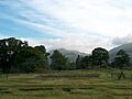
Ambleside Roman Fort today.
-
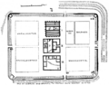
An old plan of the fort from 1915.
-
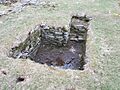
The strong-room where the soldiers' money was kept.
See Also
