Amboy, Washington facts for kids
Quick facts for kids
Amboy, Washington
|
|
|---|---|

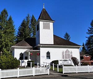
North Clark Historical Museum
|
|

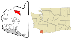
Location of Amboy, Washington
|
|
| Country | United States |
| State | Washington |
| County | Clark |
| Area | |
| • Total | 10.00 sq mi (25.91 km2) |
| • Land | 9.98 sq mi (25.86 km2) |
| • Water | 0.02 sq mi (0.04 km2) |
| Elevation | 410 ft (125 m) |
| Population
(2020)
|
|
| • Total | 1,838 |
| • Density | 161/sq mi (62.2/km2) |
| Time zone | UTC-8 (Pacific (PST)) |
| • Summer (DST) | UTC-7 (PDT) |
| ZIP code |
98601
|
| Area code | 360 |
| FIPS code | 53-01850 |
| GNIS feature ID | 1515846 |
Amboy is a small community in Clark County, Washington, United States. It's known as a census-designated place (CDP), which means it's an area identified by the government for statistics, but it's not officially a city or town with its own local government. In 2020, about 1,838 people lived there. Amboy is located about 33 miles northeast of Vancouver, which is part of the larger Portland-Vancouver area.
History of Amboy
Amboy got its name from a man named Amos M. Ball. He moved to the area in 1879. His family later helped run the local Post Office, which opened in 1880.
There are a couple of stories about how the name "Amboy" came to be:
- Some say that several early settlers, including Amos M. Ball, had the initials A.M.B. They supposedly called themselves the "A.M. Boys." Ball then named the town after this group.
- Another story suggests that the town was named after Ball's son, whom people in the area called the "A.M. Boy."
A special old building in Amboy is the Amboy United Brethren Church. It was built in 1910. In the year 2000, this historic church was turned into a museum, where you can learn about the area's past.
Where is Amboy?
Amboy is located in the northern part of Clark County. It sits where two creeks, Chelatchie Creek and Cedar Creek, meet. Cedar Creek flows into the Lewis River.
The main road that goes through Amboy is Washington State Route 503. This road connects Amboy to other nearby places. If you travel southwest on this road, you'll reach Lewisville in about 11 miles. If you go northeast for about 11 miles, you'll get to Yale. Amboy is also about 30 miles northeast of Vancouver, Washington.
According to information from 2010, the total area of Amboy is about 10 square miles (25.9 square kilometers). Only a very small part of this area, about 0.015 square miles (0.04 square kilometers), is water.
People of Amboy
In 2020, the population of Amboy was 1,838 people. This was an increase from 1,608 people counted in 2010.
Back in 2000, there were 2,085 people living in Amboy. Most of the people living there were White. There were also smaller groups of Native American, African American, Asian, and Pacific Islander residents. Some people identified as being from two or more races. A small percentage of the population was Hispanic or Latino.
Many families live in Amboy. In 2000, about 45% of households had children under 18 living with them. The average household had about 3 people. The average age of people in Amboy was 31 years old. About 36% of the population was under 18, showing it's a community with many young people and families.
See also
 In Spanish: Amboy (Washington) para niños

