Ambrose, Georgia facts for kids
Quick facts for kids
Ambrose, Georgia
|
|
|---|---|

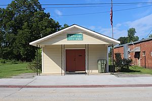
Ambrose City Hall
|
|

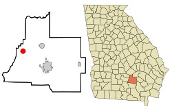
Location in Coffee County and the state of Georgia
|
|
| Country | United States |
| State | Georgia |
| County | Coffee |
| Area | |
| • Total | 3.13 sq mi (8.12 km2) |
| • Land | 3.05 sq mi (7.90 km2) |
| • Water | 0.08 sq mi (0.22 km2) |
| Elevation | 308 ft (94 m) |
| Population
(2020)
|
|
| • Total | 327 |
| • Density | 107.21/sq mi (41.39/km2) |
| Time zone | UTC-5 (Eastern (EST)) |
| • Summer (DST) | UTC-4 (EDT) |
| ZIP code |
31512
|
| Area code(s) | 912 |
| FIPS code | 13-02060 |
| GNIS feature ID | 0310508 |
Ambrose is a small city located in Coffee County, Georgia, in the United States. It's a quiet place with a friendly community. In 2020, about 327 people called Ambrose home.
Contents
Where is Ambrose Located?
Ambrose is found in the southern part of Georgia. Its exact location is 31°35′38″N 83°0′57″W / 31.59389°N 83.01583°W. This means it's just north of the Equator and west of the Prime Meridian.
How Big is Ambrose?
The city covers a total area of about 3.1 square miles (8.1 square kilometers). Most of this area is land, with a small part being water. This makes Ambrose a fairly small city in terms of size.
Who Lives in Ambrose?
Understanding the population of a city helps us learn about its community. This is called demographics.
Population Changes Over Time
The number of people living in Ambrose has changed over the years. Here's a quick look at how the population has grown and shrunk:
| Historical population | |||
|---|---|---|---|
| Census | Pop. | %± | |
| 1960 | 244 | — | |
| 1970 | 253 | 3.7% | |
| 1980 | 360 | 42.3% | |
| 1990 | 288 | −20.0% | |
| 2000 | 320 | 11.1% | |
| 2010 | 380 | 18.8% | |
| 2020 | 327 | −13.9% | |
| U.S. Decennial Census | |||
In 2020, the population was 327 people. This was a bit less than in 2010, when 380 people lived there.
See also
 In Spanish: Ambrose (Georgia) para niños
 | James Van Der Zee |
 | Alma Thomas |
 | Ellis Wilson |
 | Margaret Taylor-Burroughs |

