Amity, Allegany County, New York facts for kids
Quick facts for kids
Amity, New York
|
|
|---|---|

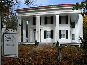
The Magnolia House
|
|
| Country | United States |
| State | New York |
| County | Allegany |
| Government | |
| • Type | Town Council |
| Area | |
| • Total | 34.60 sq mi (89.62 km2) |
| • Land | 34.48 sq mi (89.31 km2) |
| • Water | 0.12 sq mi (0.32 km2) |
| Elevation | 1,385 ft (422 m) |
| Population
(2020)
|
|
| • Total | 2,185 |
| • Estimate
(2021)
|
2,161 |
| • Density | 63.46/sq mi (24.50/km2) |
| Time zone | UTC-5 (Eastern (EST)) |
| • Summer (DST) | UTC-4 (EDT) |
| FIPS code | 36-003-02011 |
| GNIS feature ID | 0978676 |
Amity is a town located in Allegany County, New York, United States. The word "Amity" means "friendship," which is a nice name for a town! In 2020, about 2,185 people lived there.
The Town of Amity is found near the center of Allegany County. It is northeast of a city called Olean. The main office for the county, known as the county seat, is in a village called Belmont, which is part of Amity.
Contents
History of Amity
Amity was first settled around 1804. It officially became a town in 1830. Parts of Amity were taken from two other towns, Angelica and Scio. Later, in 1856, a section of Amity was used to create a new town called Ward.
Famous Person from Amity
- Hamilton Ward, Sr. was a well-known person from Amity. He served as a congressman and also as a judge.
Exploring Amity's Geography
Amity covers a total area of about 34.6 square miles (89.62 square kilometers). Most of this area is land, with a small part being water.
The Genesee River flows north through the town. A major highway, the Southern Tier Expressway (also known as New York State Route 17 or Interstate 86), runs through the northwest part of Amity, just north of Belvidere. Two other important roads, New York State Route 19 and New York State Route 244, meet in Belmont.
Amity's Population Over Time
| Historical population | |||
|---|---|---|---|
| Census | Pop. | %± | |
| 1830 | 872 | — | |
| 1840 | 1,354 | 55.3% | |
| 1850 | 1,792 | 32.3% | |
| 1860 | 2,268 | 26.6% | |
| 1870 | 2,087 | −8.0% | |
| 1880 | 1,972 | −5.5% | |
| 1890 | 1,996 | 1.2% | |
| 1900 | 2,216 | 11.0% | |
| 1910 | 2,071 | −6.5% | |
| 1920 | 1,843 | −11.0% | |
| 1930 | 1,867 | 1.3% | |
| 1940 | 1,935 | 3.6% | |
| 1950 | 1,997 | 3.2% | |
| 1960 | 2,006 | 0.5% | |
| 1970 | 2,150 | 7.2% | |
| 1980 | 2,272 | 5.7% | |
| 1990 | 2,255 | −0.7% | |
| 2000 | 2,245 | −0.4% | |
| 2010 | 2,308 | 2.8% | |
| 2020 | 2,185 | −5.3% | |
| 2021 (est.) | 2,161 | −6.4% | |
| U.S. Decennial Census | |||
In 2000, there were 2,245 people living in Amity. About 97.68% of the people were White. A small number of people were African American, Native American, or Asian. About 0.76% of the population was Hispanic or Latino.
The average household in Amity had about 2.48 people. Families, on average, had about 2.98 people. About 30.6% of households had children under 18 living with them.
The median age in the town was 39 years old. This means half the people were younger than 39, and half were older. About 25.6% of the population was under 18 years old.
Places to See in Amity
- Amity Lake – This is a small lake located near the eastern border of the town.
- Belmont – This village is the county seat, meaning it's where the main government offices for Allegany County are located. It's right in the middle of Amity.
- Belvidere – This is a small community, or hamlet, in the northwest part of Amity. It's on State Route 19. It used to be called "Hobbyville." The Belvidere Cornerstone is a historic building here.
- Withey – Another small community in the northeast corner of the town. It's located on Route 244.
- Plum Bottom Creek – A creek that flows through the Town of Amity.
See also
 In Spanish: Amity (Nueva York) para niños


