An Sgùrr (Eigg) facts for kids
Quick facts for kids An Sgùrr |
|
|---|---|

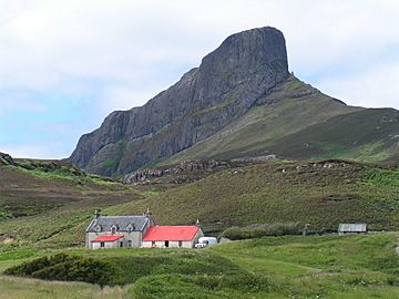
The Nose of Sgùrr, seen from the southeast
|
|
| Highest point | |
| Elevation | 393 m (1,289 ft) |
| Prominence | 393 m (1,289 ft) |
| Parent peak | none - HP Eigg |
| Listing | Marilyn, Hardy |
| Naming | |
| English translation | The (rocky) peak |
| Language of name | Gaelic |
| Geography | |
|
Lua error in Module:Location_map at line 420: attempt to index field 'wikibase' (a nil value).
|
|
| OS grid | NM463847 |
| Topo map | OS Landranger 39 |
An Sgùrr is the tallest hill on the Scottish island of Eigg. This island is part of the Inner Hebrides in Scotland. An Sgùrr is sometimes called the Sgurr of Eigg.
What is An Sgùrr?
An Sgùrr is a special kind of hill. It stands out because of how it was made. It is 393 meters (about 1,289 feet) high. This makes it the highest point on Eigg.
How An Sgùrr Was Formed
An Sgùrr was created about 58 million years ago. This happened during one of the last eruptions of a volcano. The center of this ancient volcano is now the Isle of Rùm.
Very thick, sticky lava flowed out. This lava was called pitchstone, a type of volcanic glass. It filled an old river valley. As the lava cooled, it formed tall, upright shapes. These shapes look like giant columns. You can see similar columns at the famous Giant's Causeway in Northern Ireland.
Why An Sgùrr Looks Unique
The rock around the pitchstone lava was softer. This softer rock was basalt. Over millions of years, rain and wind wore away the softer basalt. But the hard pitchstone resisted this erosion much better.
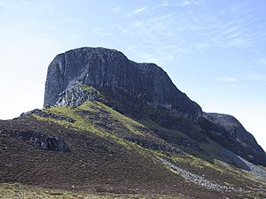
Because of this, the old river valley became "inverted." This means the hard lava that filled the valley now stands up as a hill. The softer land around it has worn away. An Sgùrr is known as an inselberg, which means an "island mountain." It looks most striking from its eastern side, which is called the Nose of Sgùrr.
Climbing An Sgùrr
Many people enjoy climbing An Sgùrr. The most common way to climb it starts from the ferry terminal. This is at Galmisdale on the southeast side of Eigg.
You follow a rough path heading west. This path goes between the north side of An Sgùrr and the sea. About three-quarters of the way along the ridge, you will find a gully. A gully is a narrow ditch or channel.
Climbing up this gully is a bit of a scramble. This means you might need to use your hands as well as your feet. It's a fairly easy climb to reach the top ridge. From there, the path turns back towards the east. It leads to the very top of the hill. At the summit, you will see a trig point. This is a small pillar used for surveying.
The whole climb, from the ferry terminal to the Nose of An Sgùrr and back, usually takes at least four hours. It's a great way to see amazing views of Eigg and the surrounding islands.
 | Leon Lynch |
 | Milton P. Webster |
 | Ferdinand Smith |


