
Anantapur district facts for kids
Anantapur district, also called Anantapuram, is a cool place in the Rayalaseema region of Andhra Pradesh, India. The main city and headquarters of the district is Anantapur. Back in 2011, about 4 million people lived here. Around 28% of them lived in cities. Most people, about 64%, could read and write. Anantapur is the biggest district in Andhra Pradesh by size. It's also the 7th largest district in all of India!
Contents
Exploring Anantapur's Geography

Anantapur is the largest district in Andhra Pradesh. It covers a huge area of about 19,130 square kilometers (7,390 sq mi). This is almost as big as Japan's Shikoku Island!
Where is Anantapur Located?
The district has neighbors all around it. To the north, you'll find Kurnool District. To the east is Kadapa District. In the southeast, it borders Chittoor District. To the southwest and west, it touches the state of Karnataka. Anantapur is part of the Rayalaseema region in Andhra Pradesh.
Land and Rivers
The northern and central parts of Anantapur are mostly a high, wavy plateau. You'll see large granite rocks and low hills here and there. In the southern part, the land is more hilly. The plateau there rises to about 2,000 feet (610 meters) above sea level.
Six rivers flow through this district. They are the Penna, Chithravathi, Vedavathi, Papagni, Swarnamukhi, and Thadakaleru. The district usually gets about 381 millimeters of rain each year.
Getting Around Anantapur
Anantapur city is about 354 kilometers (220 miles) from Hyderabad. It's also 200 kilometers (120 miles) from Bangalore, a nearby state capital. You can travel between Anantapur, Hyderabad, and Bangalore using National Highway 7.
There's an airport in Puttaparthi called Sri Sathya Sai Airport. However, it doesn't have regular flights right now. The closest airport with commercial flights is Bangalore International Airport.
People of Anantapur
Population and Homes
According to the 2011 census, Anantapur district had 4,081,148 people living in it. There were also 968,160 homes. This makes it the 7th most populated district in Andhra Pradesh. It's also the biggest district in the state by land area.
Gender and Education
For every 1000 boys, there were about 977 girls in Anantapur. This is called the sex ratio. The district's literacy rate was about 63.57%. This means most people could read and write. About 28.9% of all the people in the district lived in cities.
Images for kids
-
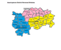
Anantapur District Revenue Divisions and Mandals

See also
 In Spanish: Distrito de Anantapur para niños
