
Andover Canal facts for kids
Quick facts for kids Andover Canal |
|
|---|---|

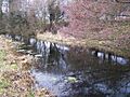
Remains of the Andover canal near Romsey
|
|
| Specifications | |
| Length | 22 miles (35 km) |
| Maximum boat length | 65 ft 0 in (19.81 m) |
| Maximum boat beam | 8 ft 6 in (2.59 m) |
| Locks | 24 (level dropped 179 ft (55 m)) |
| Status | Railway built over route |
| History | |
| Original owner | Andover Canal Navigation Company |
| Principal engineer | Robert Whitworth |
| Date of act | 1789 |
| Date of first use | 1794 |
| Date closed | 1859 |
| Geography | |
| Start point | Andover |
| End point | Southampton Water |
| Connects to | Salisbury and Southampton Canal |
The Andover Canal was a waterway built in Hampshire, England. It was like a man-made river for boats. It stretched about 22 miles (35 km) from Andover to Redbridge. The canal passed through towns like Stockbridge and Romsey.
Along its path, the canal dropped 179 feet (55 meters) using 24 locks. Locks are like water elevators that help boats move up or down between different water levels. For most of its journey, the canal ran next to the River Anton and River Test.
The Andover Canal opened in 1794. However, it was never very successful as a business. The people who invested in the canal (called shareholders) only received money back once. This happened in 1859 when the canal was sold to the London and South Western Railway. The railway company bought the canal to build a train line along its route. Interestingly, that railway line is also no longer used today.
Contents
History of the Andover Canal
Early Plans for the Canal
The idea for the Andover Canal started a long time ago. In 1770, a survey was done by Robert Whitworth. This was a time when many canals were being built across England. The plan was for the canal to follow the River Anton valley. Then it would join the River Test and follow that river down to Redbridge.
Robert Whitworth estimated how much it would cost to build the canal. He gave prices for both a narrow and a wider canal. The next year, people tried to get permission from Parliament to build it. They even mentioned an old law from the time of King Charles II. This law had given rights to make rivers like the Test and Anton navigable (meaning boats could use them).
However, the plan didn't go forward at that time. Some people thought it was because of problems buying land. Others believed it was because not enough people wanted to invest money.
Building the Canal
Interest in the canal project grew again in 1788. A meeting was held in Andover on August 4th. The Andover Corporation (the local government) supported the idea. A special committee was formed, and Robert Whitworth did another survey.
The estimated cost was £35,000. Within just two weeks, over £19,000 had been promised by investors. By March 1789, when the plan was officially given to Parliament, this amount had grown to £30,700.
On July 13, 1789, Parliament passed an Act (a law) allowing the canal to be built. This law created "The Company of Proprietors of the Andover Canal Navigation." This company could raise £35,000 by selling shares. They could also raise an extra £30,000 if needed. This extra money could come from more shares or loans. A group of 15 owners managed the company.
The Act had some interesting rules. It said the canal could be open from 4:00 AM to 10:00 PM. It also set the maximum size for barges (boats) at 60 feet (18.3 meters) long and 8 feet (2.4 meters) wide. Boats could not be deeper than 3.5 feet (1.1 meters).
The canal was finished in 1794. It cost £48,000 in total. £35,000 came from shares, and £13,000 was borrowed. The canal locks were built a bit bigger than the law allowed. They could handle boats up to 65 feet (19.8 meters) long and 8 feet 6 inches (2.6 meters) wide.
What the Canal Carried
The main things carried on the canal were coal, slates, and manure. These came in from Southampton Water. Farm products like crops went out from Andover. However, boats often struggled to find goods to carry on the return journey to Southampton Water.
The canal was never very profitable. It didn't pay any money back to its investors (shareholders) until it closed in 1859. At that time, the money from selling the canal to the Andover & Redbridge Railway provided the only payment to shareholders. By 1827, the canal company was eight years behind on its loan interest payments. This improved a bit by 1851, but problems continued.
The Canal's End
In 1845, a company called the Manchester and Southampton Railway (MSR) agreed to buy the canal for £30,000. But this plan didn't work out. Two years later, the MSR tried again to get a law passed for their railway line, but it failed again.
However, the London and South Western Railway (LSWR) managed to get a law passed. This law allowed them to build a railway line from Salisbury to Basingstoke, which would go through Andover. They were also allowed to buy the canal.
Work on this railway line stopped in 1849. At this point, the canal company bought the sixteen barges that used the canal. They decided to operate the boats themselves. This helped solve problems with boat operators asking for lower fees.
The two railway companies (MSR and LSWR) decided the canal should close. This would happen once the canal shareholders were paid. £9,000 was paid in 1851, but the rest of the money wasn't paid. Local landowners then started a company to finish the railway link. The railway reached Andover in 1854. After this, the canal tried to keep its business by lowering its fees. But this meant even less money, and they couldn't pay interest on their loans.
Many talks and deals happened next. The GWR (Great Western Railway) tried to buy the canal. Then they encouraged the canal company to form a new company to build a railway along the canal's route. In the end, the LSWR bought the canal. The canal stopped working on September 19, 1859. The new railway line, nicknamed the Sprat and Winkle Line, opened on March 6, 1865. About 14.5 miles (23.3 km) of the canal's path were used for the railway.
Much of this railway line has also been closed down since then. Because of this, most signs of the old canal have disappeared. However, you can still see parts of the canal between Timsbury and Romsey. You can also find stretches of the canal next to the old railway track. For example, at Brook and between Westover and Fullerton, you can see stone and brick remains of a lock.
The Canal's Route
The Andover Canal started on the south side of the River Anton in Andover. It then followed the river until it met the River Test. The canal crossed both rivers using two aqueducts. An aqueduct is like a bridge that carries water.
Below the aqueducts, the canal followed the east bank of the River Test down to Redbridge. Near Kimbridge, there was a connection to the Salisbury and Southampton Canal. At Redbridge, the canal joined the River Test, which allowed boats to reach Southampton Water. The canal was 22 miles (35 km) long. Its 24 locks lowered the water level by 179 feet (55 meters) from Andover to Redbridge.
Points of interest
| Point | Coordinates (Links to map resources) |
OS Grid Ref | Notes |
|---|---|---|---|
| Andover Wharf | 51°12′16″N 1°28′56″W / 51.2044°N 1.4823°W | SU362451 | |
| Andover | 51°11′39″N 1°29′34″W / 51.1943°N 1.4929°W | SU355440 | |
| Goodworth Clatford | 51°10′42″N 1°28′57″W / 51.1783°N 1.4825°W | SU362422 | railway line |
| Remains of canal | 51°09′44″N 1°27′55″W / 51.1621°N 1.4654°W | SU374404 | railway line straighter |
| River Anton aqueduct | 51°09′14″N 1°27′36″W / 51.1539°N 1.4601°W | SU378395 | |
| River Test aqueduct | 51°09′03″N 1°27′19″W / 51.1509°N 1.4554°W | SU381392 | |
| Stockbridge | 51°06′50″N 1°29′18″W / 51.1139°N 1.4883°W | SU359350 | railway line |
| Jn with Salisbury & Southampton Canal | 51°02′06″N 1°31′41″W / 51.0351°N 1.5280°W | SU331263 | Kimbridge |
| Timsbury | 51°01′27″N 1°30′48″W / 51.0241°N 1.5134°W | SU342250 | |
| Romsey | 50°59′57″N 1°29′15″W / 50.9992°N 1.4875°W | SU360223 | |
| Remains of canal | 50°57′34″N 1°29′04″W / 50.9595°N 1.4844°W | SU363179 | |
| Nursling | 50°56′14″N 1°29′06″W / 50.9371°N 1.4849°W | SU362154 | railway line straighter |
| Jn with River Test | 50°55′21″N 1°28′32″W / 50.9226°N 1.4755°W | SU369138 |
Images for kids
-
Surviving section of Andover Canal near Nursling, between Redbridge and Romsey.

