
Salisbury and Southampton Canal facts for kids
Quick facts for kids Salisbury and Southampton Canal |
|
|---|---|

The presence of the canal bed, which ran left to right, caused problems during the construction of Clover Nook, seven blocks of flats built on Old Redbridge Road. The nearest block is numbers 81 to 96.
|
|
| Specifications | |
| Maximum boat length | 60 ft 0 in (18.29 m) |
| Maximum boat beam | 8 ft 0 in (2.44 m) |
| Locks | 16 or 17 |
| Status | Mainly destroyed |
| History | |
| Original owner | Proprietors of the Salisbury and Southampton Canal |
| Principal engineer | John Rennie |
| Date of act | 1795 |
| Date of first use | 1802 |
| Date closed | 1808 |
| Geography | |
| Start point | Salisbury |
| End point | Southampton |
| Connects to | Andover Canal, River Test, River Itchen |
The Salisbury and Southampton Canal was a waterway planned to be about 13 miles (21 km) long in southern England. It was meant to connect Redbridge, a part of Southampton, with the city of Salisbury. The canal aimed to link up with the Andover Canal near Mottisfont. Another part of the canal was supposed to go through Southampton and connect to the River Itchen using a tunnel.
Contents
Building the Salisbury and Southampton Canal
The idea for a canal from Salisbury to Redbridge first came up in 1768. A famous canal engineer named James Brindley even surveyed a possible route. Two years later, another engineer, Robert Whitworth, was planning a canal from Andover to Redbridge. The people in Salisbury wanted their canal to join Whitworth's canal.
However, the plans didn't work out at first. In 1772, a bill for the Andover canal wasn't approved by Parliament. This meant the Salisbury canal project also stopped for a while.
Getting Started and Facing Problems
The route was surveyed again in 1793. Then, in 1795, a special law called an Act of Parliament was passed. This law allowed the canal to be built. The owners hired Joseph Hill as the surveyor. He thought the canal would cost about £50,000.
Even though many business people from Bristol supported the idea, many shareholders didn't pay their money. This meant the company always had money problems. Building a tunnel in Southampton was very difficult. John Rennie, another engineer, looked at the work and said it wasn't done well.
Money Troubles and Closure
Joseph Hill left the project soon after. In 1800, a new Act of Parliament was passed to try and raise more money. But it was still hard to find new shareholders. They hired George Jones as the engineer, and some progress was made.
By early 1803, parts of the canal were being used. Boats could travel from the west end of the tunnel to Redbridge. They could also go from Kimbridge (on the Andover Canal) to West Grimstead, which is about 4 miles (6.4 km) east of Salisbury.
But the company still struggled to find enough money to finish the canal. The engineer, George Jones, even sued the company because they didn't pay him. He won, and parts of the canal were taken by the authorities.
The canal collected tolls until at least 1804. It was used for a few more months after that. But because it wasn't looked after and some parts were damaged on purpose, the canal closed in 1806. By 1808, the company had completely stopped working.
What Happened to the Canal After It Closed?
Parts of the canal near Salisbury dried up or became small streams. But the section in Southampton became a dirty, still ditch. In 1841, a woman drowned in this part of the canal. After this, the local council decided to fill it in.
It took time to get the money and legal power to fill the canal. Work started in 1846, and the area was finally covered with grass by 1851.
Later, when the Southampton and Dorchester Railway was built, some parts of the canal's route were used for the railway. However, the old canal tunnel was not suitable for the railway. A new, bigger railway tunnel was dug in a different place. This new tunnel partly removed the old canal tunnel.
Where Can You See the Canal Today?
Very little of the canal remains today. Much of it has been built over or changed by new developments.
Southampton Section
It's hard to find traces of the Southampton part of the canal. Some street names like Canal Walk and Lower Canal Walk give a hint of where it used to be. But the canal was filled in and built over a long time ago.
During the Second World War, the area changed a lot. New roads like Queensway were built. In 1961, when a housing project called Palmerston House was being built, workers found part of a wharf (a place where boats load and unload goods).
The canal had two branches in Southampton. One came from the River Test near God's House Tower. The other came from the River Itchen. These two branches met at the eastern end of the canal tunnel. This spot is now near Palmerston Park.
The canal tunnel itself was very difficult to build. It was never fully finished or used for boats. Parts of it sank or collapsed because of bad ground conditions.
When the Southampton and Dorchester Railway built its tunnel in the 1840s, it cut through the old canal tunnel. This caused problems for the railway tunnel because water from the old canal tunnel soaked the ground. This led to parts of the railway tunnel collapsing during construction.
Even in the 1960s, the old canal tunnel caused issues for the railway. In 1975, the city council investigated the tunnel and eventually filled it with a material called flyash to stop further ground movement. The western end of the tunnel was found under what was then the R J Mitchell museum.
Further west, the canal route is now under Southampton Central railway station and the Millbrook Trading Estate. In 1964, a brick arch that carried the Tanners Brook under the canal was found. This shows that the canal bed was above the high water mark and fed by local streams.
The canal then crossed to the south of the railway line near Redbridge station. It ran along the bank of the River Test. This area has changed a lot with the building of the Prince Charles container port. The very end of this section was filled in by the Docks Board between 1963 and 1965.
The canal crossed the railway line again just east of Redbridge station. It then went north-west to join the Andover Canal. The old canal path caused problems when flats were built on Old Redbridge Road. The junction with the Andover Canal was destroyed when the Andover Railway was built in 1864.
Kimbridge to Alderbury Section
The northern part of the canal, from Kimbridge Junction to Alderbury Wharf, is easier to find. Even though the railway followed the canal's general path, it was straighter. The canal left the Andover Canal about 250 yards (230 m) south of Mottisfont railway station.
Today, parts of this section are used as the Test Way footpath. The canal crossed the River Test and the River Dun. You can still see earthworks (changes in the ground) that show its path on modern maps.
The canal wound its way, sometimes crossing the railway line. It followed the River Dun closely. You can see the old earthworks on maps almost to East Dean. The railway was built over the canal through East Dean.
Near West Dean, the canal crossed from Hampshire into Wiltshire. It continued past East Grimstead, where it is marked as "Old Canal" on maps. The only original bridge that still exists is here. It's a brick arch bridge and is a protected historical structure.
The railway again ran on top of the canal through West Grimstead. The canal then made a final loop before crossing to the south side of the railway for the last time.
Near Alderbury Junction, the canal turned south-west to avoid the high ground of Alderbury. The A36 Alderbury bypass has covered part of the old railway line here. The canal ended at a road called Tunnel Hill, near Alderbury House. A lake in the grounds of Alderbury House might have been part of the canal. Tunnel Hill might suggest that a tunnel was planned there, but it was never finished.
Another feature of the canal was its feeder reservoirs, which supplied water. One still remains at Pope's Bottom, above the road from Alderbury to Farley. The feeder passes under the road through an original bridge.
Images for kids
-
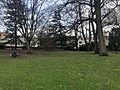
This image shows the area where the canal tunnel was located in Palmerston Park, Southampton.

Points of Interest
The table below shows some key locations along the canal's route.
| Point | Coordinates (Links to map resources) |
OS Grid Ref | Notes |
|---|---|---|---|
| Tunnel Hill Alderbury | 51°02′29″N 1°44′38″W / 51.0414°N 1.7438°W | SU180269 | approx end of construction |
| Rectory Farm Alderbury | 51°02′05″N 1°43′52″W / 51.034795°N 1.731244°W | SU189261 | canal passed round farm |
| Summit level cutting | 51°02′30″N 1°42′52″W / 51.0418°N 1.7145°W | SU201269 | between 2 railway embankments |
| Surviving bridge | 51°02′39″N 1°40′50″W / 51.0441°N 1.6806°W | SU224272 | by East Grimstead Church |
| Remains of lock 9 | 51°02′36″N 1°39′04″W / 51.0432°N 1.6510°W | SU245271 | under bridge on farm track |
| Remains of lock | 51°02′25″N 1°35′20″W / 51.0404°N 1.5890°W | SU289268 | by road to Holbury Wood |
| Dunbridge embankment | 51°01′53″N 1°33′29″W / 51.0314°N 1.5581°W | SU310258 | |
| Junction with Andover Canal | 51°02′05″N 1°31′36″W / 51.0348°N 1.5268°W | SU332262 | approx |
| Southampton Branch west end | 50°55′29″N 1°28′33″W / 50.9247°N 1.4757°W | SU369140 | |
| Route through container terminal | 50°54′46″N 1°27′51″W / 50.9129°N 1.4641°W | SU377127 | service road follows canal |
| Route discernible in 1966 | 50°54′27″N 1°25′11″W / 50.9076°N 1.4196°W | SU409121 | Woods near Central station |
| Western end of tunnel | 50°54′26″N 1°24′30″W / 50.9073°N 1.4082°W | SU417121 | |
| Eastern end of tunnel | 50°54′23″N 1°24′05″W / 50.9064°N 1.4015°W | SU421120 | |
| End of River Test branch | 50°53′45″N 1°24′08″W / 50.8959°N 1.4022°W | SU421108 | God's House Tower |
| End of River Itchen branch | 50°54′49″N 1°22′57″W / 50.9135°N 1.3826°W | SU434128 | Wharf near Northam Bridge |
