
Angoville, Calvados facts for kids
Quick facts for kids
Angoville
|
|
|---|---|
|
Part of Cesny-les-Sources
|
|

The road into Angoville
|
|

Angoville
Location in France

Angoville
Location in Normandy
|
|
| Country | France |
| Region | Normandy |
| Department | Calvados |
| Arrondissement | Caen |
| Canton | Le Hom |
| Commune | Cesny-les-Sources |
| Area
1
|
3.72 km2 (1.44 sq mi) |
| Population
(2019)
|
24 |
| • Density | 6.45/km2 (16.7/sq mi) |
| Time zone | UTC+01:00 (CET) |
| • Summer (DST) | UTC+02:00 (CEST) |
| Postal code |
14220
|
| Elevation | 173–248 m (568–814 ft) (avg. 220 m or 720 ft) |
| 1 French Land Register data, which excludes lakes, ponds, glaciers > 1 km2 (0.386 sq mi or 247 acres) and river estuaries. | |
Angoville was once a small village, or commune, located in the Calvados area of Normandy, a region in north-western France. On January 1, 2019, Angoville joined with other nearby villages to form a new, larger commune called Cesny-les-Sources.
Contents
Geography
Angoville is about 30 kilometers (18.6 miles) south of a city called Caen. It's also about 10 kilometers (6.2 miles) east of Thury-Harcourt. A road named D6 forms the northern edge of the area where Angoville used to be. You can get to the village by taking the D241 road from Tréprel in the south. This road goes right through the village. Most of the land around Angoville is used for farming. There's also a forest in the south called Bois de Saint-Claire.
 |
Meslay | Acqueville | Tournebu | |
| Donnay | Martainville | |||
| Saint-Omer | Pierrefitte-en-Cinglais | Saint-Germain-Langot |
History
What's in a Name?
The name Angoville has an interesting history! It comes from two parts. The first part, "ville," is an old French word. It means a rural area or a village. The second part comes from a Scandinavian name, Asgaut (or Asgautr). Over time, this name changed to Asgot, Ansgot, Angot, and then Ango. So, Angoville basically means "the village of Ango" or "Ango's farm."
Administration
Administration is about how a town or village is managed. Before Angoville became part of Cesny-les-Sources, it had its own mayors. A mayor is the leader of a town or city.
List of Mayors of Angoville
| From | To | Name | Party | Job |
|---|---|---|---|---|
| ? | ? | Louis-Aimable Auvray | Farmer | |
| ? | ? | M. Pourdais (Father) | ||
| ? | 2001 | Guy Bourdais | ||
| 2001 | 2014 | Daniel Simon | Independent | Farmer |
| 2014 | 2019 | Éric Sohier | Independent | Editor |
Demography
Demography is the study of how populations change over time. This includes how many people live in a place and how that number changes. People who lived in Angoville were called Angovillais (for boys and men) or Angovillaises (for girls and women).
| Historical population | |||||||||||||||||||||||||||||||||||||||||||||||||||||||||||||||||||||||||||||||||||||||||||||||||||||||||||||||||||
|---|---|---|---|---|---|---|---|---|---|---|---|---|---|---|---|---|---|---|---|---|---|---|---|---|---|---|---|---|---|---|---|---|---|---|---|---|---|---|---|---|---|---|---|---|---|---|---|---|---|---|---|---|---|---|---|---|---|---|---|---|---|---|---|---|---|---|---|---|---|---|---|---|---|---|---|---|---|---|---|---|---|---|---|---|---|---|---|---|---|---|---|---|---|---|---|---|---|---|---|---|---|---|---|---|---|---|---|---|---|---|---|---|---|---|---|
|
|
||||||||||||||||||||||||||||||||||||||||||||||||||||||||||||||||||||||||||||||||||||||||||||||||||||||||||||||||||
| Source: EHESS and INSEE | |||||||||||||||||||||||||||||||||||||||||||||||||||||||||||||||||||||||||||||||||||||||||||||||||||||||||||||||||||
Economy
The main jobs and businesses in Angoville were related to farming. People mostly focused on dairy farming (raising cows for milk) and growing crops.
Culture and Heritage
Heritage refers to things from the past that are important to a place's history and culture. Angoville has several interesting historical sites.
Civil Heritage
Civil heritage includes buildings and places that are not religious. These are registered as historical monuments, meaning they are protected because of their importance.
- Houses and Farms (from the 18th and 19th centuries)
- A Farmhouse (built in 1786)
- The Saint Anne Fountain (built in 1848)
- The Town Hall (from the 19th century)
- The Motte de Rouvrou Fortified Site (from the 11th century) - This was an old type of castle or fort built on a mound.
Religious Heritage
Religious heritage includes buildings and sites related to faith.
- The Tomb of the Rabâche family (from the 19th century)
- The Tomb of Jean-François Rabâche (from 1816)
- The Tomb of Priest François Bouquet (from 1813)
- The Parish Church of Saint-Anne (built in the 12th century) - This is a very old church!
Images for kids
-
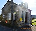
The Town Hall
-
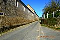
A street in Angoville
-
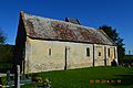
The Church of Saint Anne


See also
 In Spanish: Angoville para niños
