
Annette Island facts for kids


Annette Island, known as Taak'w Aan in the Tlingit language, is an island located in Alaska. It's part of the Gravina Islands within the Alexander Archipelago, found on the southeastern coast of the U.S. state of Alaska. The island is about 18 kilometers (11 miles) long and 18 kilometers (11 miles) wide. Its land area is about 332.5 square kilometers (128.4 square miles).
Annette Island was named in 1879 by William Healey Dall, an American explorer, in honor of his wife, Annette Whitney Dall. The Tlingit name Taak'w Aan means "Winter Town."
Since the late 1800s, Annette Island has been the home of the Annette Island Reserve. This reserve belongs to the Metlakatla Alaska Native Community, who are mostly Tsimshian people. This is the only Indian reservation in Alaska. The Metlakatla community chose to keep their lands instead of giving them up under the Alaska Native Claims Settlement Act in the 1970s. In 2016, Audrey Hudson was elected as their first Tribal Chairwoman.
Contents
Community Life
The biggest town on Annette Island is Metlakatla. The Metlakatla Indian Community was started by William Duncan, a missionary, and his Tsimshian followers. They moved to Annette Island from their old community in British Columbia.
The entire island has been an Indian reserve since the late 1800s. The Tlingit people agreed to let the Tsimshian use this land.
Island Connections
.jpg)
Over the years, a network of roads and trails was built on the island, mainly for logging. For more than 50 years, the United States had promised to build a road across the island. This promise was made in exchange for the Metlakatla Community allowing an airfield to be built and used on the island.
Finally, between 1997 and 2007, a joint task force from the armed forces built a 15-mile road across the island. This road connects Metlakatla on one side of the island to the side facing Ketchikan, where a ferry landing was built.
After World War II, the airfield on Annette Island was used by the United States Coast Guard as a Search and Rescue base. It also served commercial airplanes until the 1970s, when a new airport was built at Gravina Island.
Weather on Annette Island

Annette Island has a Marine west coast climate. This means it has windy and wet weather all year round. Winters are cool, and summers are mild. Because of its location near the ocean and to the south, the Annette Island Airport is one of the warmest places in Alaska.
It rains on most days during the winter. Snow usually falls from November to March, but it's rare in May and October. In summer, the temperature can reach 70°F (21°C) or higher about 17 days a year. The island gets a lot of rain, over 103 inches (2.6 meters) annually. June and July are the driest months, while October and November are the wettest.
The coldest temperature ever recorded was -4°F (-20°C) in January 1947. The hottest was 93°F (34°C) in June 2004. Annette Island Airport also holds Alaska's record high temperatures for January (66°F or 19°C), April (82°F or 28°C), and November (67°F or 19°C).
Population Changes
The population of Annette Island has changed over the years.
- In 1950, about 302 people lived there.
- The population grew to 337 in 1960.
- By 1970, it dropped to 195.
- In 1980, there were 139 people.
- By 1990, the population was 43.
Annette first appeared on the U.S. Census in 1950. In 1980, it was named a census-designated place (CDP), which is a special area for counting population. It was last counted in 1990 and was no longer a CDP after the year 2000.
Images for kids
-
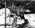
Fish trap on Tamgas Stream, Annette Island, July 1910
.jpeg)
