Antone, Oregon facts for kids
Quick facts for kids
Antone, Oregon
|
|
|---|---|

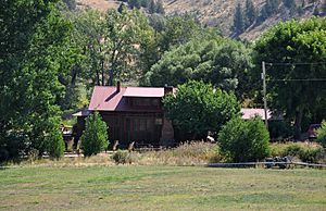
Ranch house at Antone in 2011
|
|
| Country | United States |
| State | Oregon |
| County | Wheeler |
| Named for | Antone Francisco, a pioneer settler |
| Elevation | 3,458 ft (1,054 m) |
| Time zone | UTC-8 (PST) |
| • Summer (DST) | UTC-7 (PDT) |
| Area code(s) | 541 |
| Coordinates and elevation from United States Geological Survey | |
Antone is a small, former community located in Wheeler County, Oregon. It's not a town anymore, but it used to be a place where people lived. You can find Antone south of U.S. Route 26, which is a main road between the towns of Mitchell and Dayville.
Where is Antone?
Antone is in a scenic part of Oregon. A gravel road called Antone Lane runs near Route 26. This road connects to Route 26 both east of Mitchell and west of Dayville.
The road crosses Rock Creek at Antone. Rock Creek is a smaller stream that flows into the John Day River. South of Antone, you can find the Ochoco Mountains and the Ochoco National Forest. These are beautiful natural areas.
How Antone Got Its Name
The area was named Antone in the early 1890s. It was named after Antone Francisco, who was a pioneer settler. He was of Portuguese descent.
Antone's Post Office
Antone once had its own post office. It was open from 1894 until 1948. There was a short break in service for three years during that time.
A Place of History
Antone was once an important spot for the U.S. Army. In 1864, a barracks (a building for soldiers) was built there. This was to help protect miners and other travelers. It was built after some conflicts happened in the area.
The barracks were located along a wagon road. This road was later renamed The Dalles Military Road around 1870. It connected The Dalles on the Columbia River to gold mines near Canyon City.
See also
 In Spanish: Antone (Oregón) para niños
 | Sharif Bey |
 | Hale Woodruff |
 | Richmond Barthé |
 | Purvis Young |


